
MyTopo
Darlington East South Carolina US Topo Map
Couldn't load pickup availability
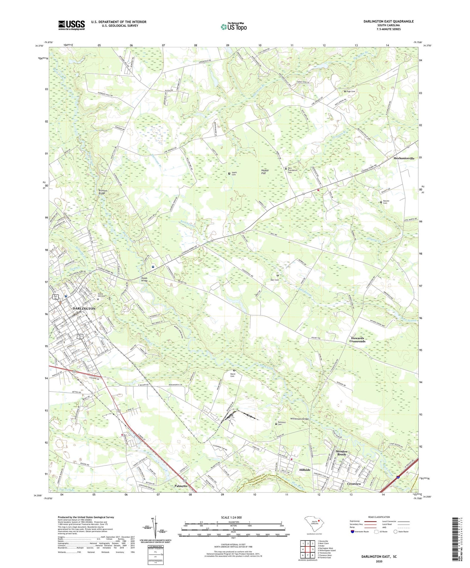
2020 topographic map quadrangle Darlington East in the state of South Carolina. Scale: 1:24000. Based on the newly updated USGS 7.5' US Topo map series, this map is in the following counties: Darlington, Florence. The map contains contour data, water features, and other items you are used to seeing on USGS maps, but also has updated roads and other features. This is the next generation of topographic maps. Printed on high-quality waterproof paper with UV fade-resistant inks.
Quads adjacent to this one:
West: Darlington West
Northwest: Dovesville
North: Mont Clare
Northeast: Drake
East: Witherspoon Island
Southeast: Florence East
South: Florence West
Southwest: Timmonsville
Contains the following named places: Atkinson Invst Pond Dam D-3545, B A Gary Middle School, Bacot Cemetery, Bacote Cemetery, Bellyache Creek, Bethea Home for the Aged, Bowens Manor, Brunsons Bridge, Cain School, Central Baptist Church, Christ Temple Holiness Church, Church of God, City of Darlington, Crestview, Cribbs Pond Dam D-3542, Darlington Country Club, Darlington County Courthouse, Darlington County Fire Department Station 4, Darlington County Health Center, Darlington County Jail, Darlington County Library, Darlington Division, Darlington Endoscopy Center, Darlington Fireman Rescue Squad, Darlington Industrial Historic District, Fibers Recreation Pond Dam D-3549, First Baptist Church, First Presbyterian Church of Darlington, Forest Acres, Friendship Baptist Church, Goodson Pond Dam D-3544, Grove Hill Cemetery, Hasker Flat, Hillside, Hoods Bridge, Howards Crossroads, Isqett Cemetery, John James Pond Dam D-3547, Liberty Heights, Macedonia Church, Mayo Heights, Mayo School, McLeod Health Darlington, Meadow Brook, Mechanicsville, Mechanicsville Baptist Church, Mechanicsville School, Mount Sinai Church of God, Muses Bridge, New Hope Church, New Providence Cemetery, New Providence Church, New Providence School, Oak Dale, Palmetto, Palmetto Cemetery, Palmetto Church, Palmetto Rural Fire Department Station 1, Palmetto Rural Fire Department Station 2, Palmetto School, Pepper Ridge, Pine Village, Pleasant Grove Church, Pleasant Grove School, Pugh Cemetery, Saint James United Methodist Church, Saint Matthews Episcopal Church, Salem Baptist Church, Sartor Estates, South Carolina Noname 16011 D-3550 Dam, South Carolina Noname 16013 D-3543 Dam, South Carolina Noname 16027 D-3548 Dam, South Carolina Noname 16035 D-3546 Dam, South Side Church, Southland Medical Center, Springdale, Springville, Swift Creek, The Church of Jesus Christ of Latter Day Saints, Town and Country Estates, Trinity United Methodist Church, Warr Cemetery, Washington Terrace, West Broad Street Historic District, Williamson Park, Williamsons Bridge, Wilson Hospital, Woodcreek, Woodland Gardens, ZIP Code: 29532


