MyTopo
Fort Jackson North South Carolina US Topo Map
Couldn't load pickup availability
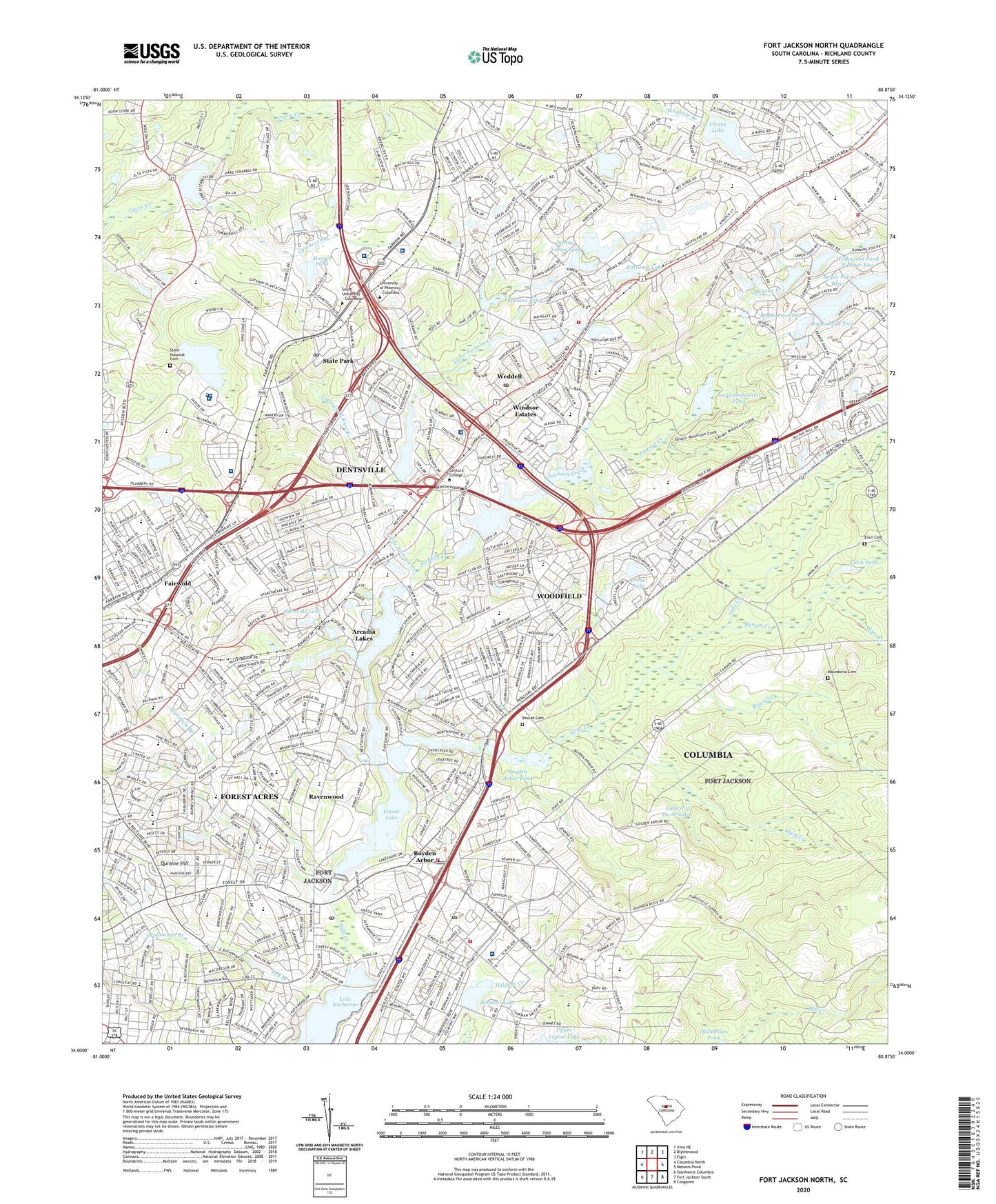
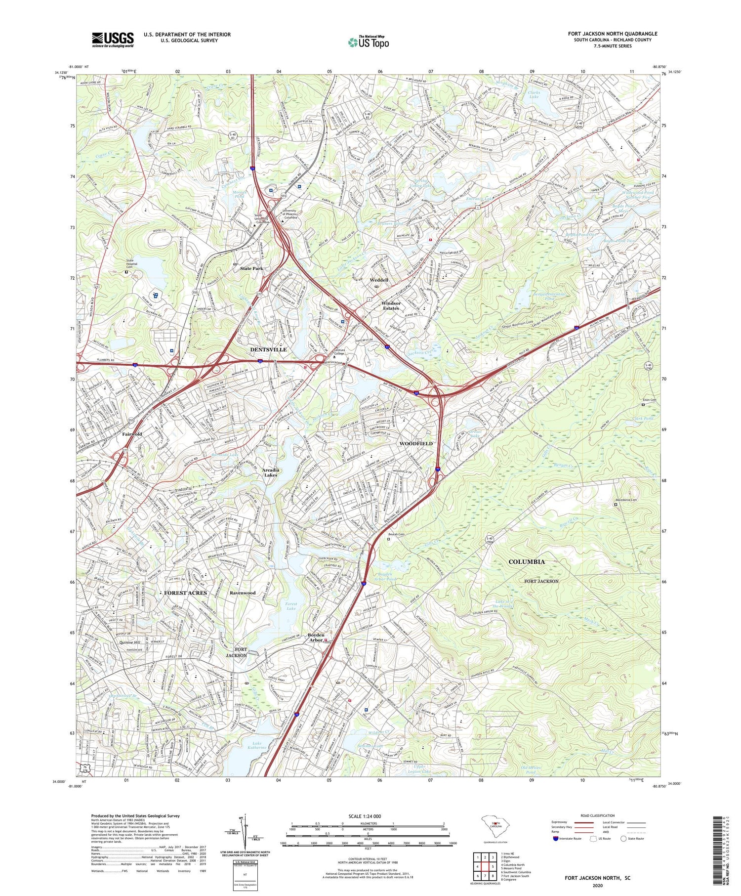
2020 topographic map quadrangle Fort Jackson North in the state of South Carolina. Scale: 1:24000. Based on the newly updated USGS 7.5' US Topo map series, this map is in the following counties: Richland. The map contains contour data, water features, and other items you are used to seeing on USGS maps, but also has updated roads and other features. This is the next generation of topographic maps. Printed on high-quality waterproof paper with UV fade-resistant inks.
Quads adjacent to this one:
West: Columbia North
Northwest: Irmo NE
North: Blythewood
Northeast: Elgin
East: Messers Pond
Southeast: Congaree
South: Fort Jackson South
Southwest: Southwest Columbia
Contains the following named places: Alcohol and Drug Abuse Lake, Anna Boyd Child Development Center, Arcadia Lakes, Arcadia Lakes Plaza Shopping Center, Arcadia Woods Lake Dam, Bethel Church, Bethel School, Beulah Cemetery, Beulah Church, Boulevard Plaza Shopping Center, Boyden Arbor, Boyden Arbor Dam - Fort Jackson, Boyden Arbor Pond, Boyds Pond One, Boyds Pond Three, Boyds Pond Two, Bradley School, Brandywine, Briarwood, Brickyard Village, Brockman School, Bruners Pond, Burnside Lake, Burnside Lake Dam, Bynum Creek, Camp Marion, Cardinal Newman High School, Carolina Childrens Home, Carolina Research Park, Carys Lake, Carys Lakes, Charleswood, Church of God, City of Columbia, City of Forest Acres, Clark Pond, Clarks Lake, Clarks Lake D-0563 Dam, Clear Springs, Columbia - Richland Fire Department Dentsville, Columbia Division, Columbia Fire Department Sand Hill Station 24, Columbia Fire Department Station 33 Gills Creek, Columbia Mall Shopping Center, Columbia Northeast Shopping Center, Columbia Regional Care Center, Columbia Richland Fire Department Station 32 Jackson Creek, Conder School, Coopers Pond, Coopers Pond Dam, Covenant Church, Crafts-Farrow State Hospital, Crayton Middle School, Cumbess Creek, Deaswood, Decker Mall Shopping Center, Decker Plaza Shopping Center, Dent Middle School, Dentsville, Dentsville Census Designated Place, Drexel Lake, Drexel Lake Hills, Dry Branch, E L Wright Middle School, East Lake Hills, Eastwood Church, Edinburgh, Eightmile Branch, Enon Cemetery, Enon Church, Entrance Lake, Entrance Lake Dam, Fair Lawn Church, Fairlawn Community Center, Fairlawn School, Fairwold, Farrowoods, Fashion Place Shopping Center, Flora High School, Folkestone, Forest Acres, Forest Drive Church, Forest Lake, Forest Lake Country Club, Forest Lake Dam, Forest Lake Park, Forest Lake School, Forest Trace, Forestwood Estates, Fort Jackson Fire Department, Foxhall, G Werber Bryan Psychiatric Hospital, Gills Creek Church, Glenwood Golf Course, Goodwyns Mills, Greenview School, Gregg Park, Hammond Park, Hampton Trace, Hood Street School, Huntcliff, Huntington, Jackson Creek, Jackson Creek Church, Jackson Creek School, Jackson School, Jiggs, Jim Hammond Pond, Keels School, Keenan Junior High School, Kilbourne Heights, Kilbourne Park, Kilbourne Park Church, L B Nelson Elementary School, Lake Elizabeth, Lake Elizabeth Estates, Lake in the Woods, Lake Katherine, Lake Katherine Dam, Lakeview, Lightwood Knot Branch, Little Jackson Creek, Longs School, Macedonia Cemetery, Macedonia Church, Mack Creek, Malone Chapel, Manning Correctional Institute, McClendon Medical Center, Midland Center, Moncrief Army Health Clinic Hospital, Moore School, Moores Pond, Moores Pond D-0555 Dam, Morris Village Treatment Center, Mount Olive Church, North Pointe Shopping Center, North Trenholm, North Washington Park, Northeast Post Office, Old Forest, Orphanage Branch, Palmetto Surgery Center Hospital, Park View Church, Patton Stadium, Pen Branch, Pine Springs Dam Number One D-0560, Pine Springs Dam Number Two D-0561, Pine Springs Lake D-0559 Dam, Pine Springs Pond D-0562 Dam, Pisgah Church, Providence Hospital Northeast, Quinine Hill, Ravenwood, Ravinwood, Rehobeth Church, Richland, Richland County, Richland Mall Shopping Center, Richland Northeast High School, Richland Northeast Vocational Annex, Rockbridge, Rockbridge Country Club, Rockford Lake, Rocky Ford Lake, Rose Creek, Rowell Creek, S A Heyward Career Center, Saint Peters Church, Sandwood, Satchel Ford Road School, Satchel Ford Terrace, Semmes Lake, Semmes Lake Dam - Fort Jackson, Sesqui, Sesquicentennial Pond, Sesquicentennial State Park, Silver Dune School, Simpson Pond, Simpson Pond Dam D-3651, South Carolina Endoscopy Center Northeast, South Carolina Noname 40002 Dam, South Carolina Noname 40005 Dam, South Carolina Noname 40013 D-0569 Dam, South Carolina Noname 40026 Dam, South Carolina Noname 40027 Dam, South Carolina Noname 40049 D-0551 Dam, Spring Lake, Spring Valley, Spring Valley Country Club, Spring Valley High School, Spring Valley Lake, Springhill, Springwood, Springwood Lake, Springwood Lake D-0558 Dam, State Hospital Cemetery, State Park, State Park Acres, Tanglewood, The Old Country Church, Timmerman School, Town of Arcadia Lakes, Trenholm Park, Trenholm Plaza Shopping Center, Upper Rocky Ford Lake, Upper Windsor Lake D-0570 Dam, WAAS-FM (Columbia), WACH-TV (Columbia), Weddell, Wedgewood, Wildewood, Wildewood Pond Five D-0564 Dam, Wildewood Pond Number Five, Wildewood Pond One D-0568 Dam, Wildewood Pond Three D-0566 Dam, Wildewood Pond Two D-0567 Dam, Wildwood School, William S Hall Psychiatric Institute, Williamsburg East, Wilson Vocational Annex, Windsor Estates, Windsor Lake, Windsor Lake Dam D-0571, Windsor Lake Park, Windsor School, WLTR-FM (Columbia), WOLO-TV (Columbia), Woodfield, Woodfield Census Designated Place, Woodfield Park, WRLK-TV (Columbia), ZIP Codes: 29147, 29206, 29223