
MyTopo
Irmo South Carolina US Topo Map
Couldn't load pickup availability
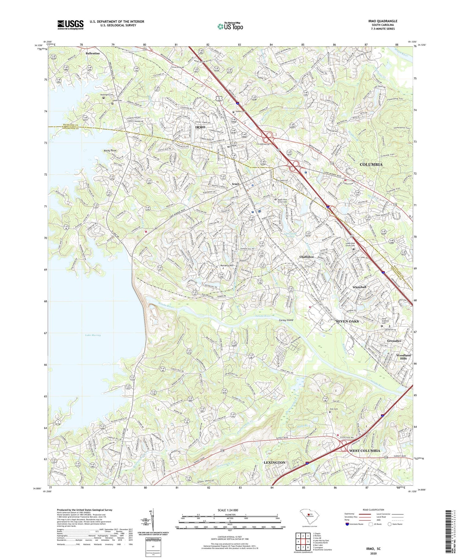
2020 topographic map quadrangle Irmo in the state of South Carolina. Scale: 1:24000. Based on the newly updated USGS 7.5' US Topo map series, this map is in the following counties: Lexington, Richland. The map contains contour data, water features, and other items you are used to seeing on USGS maps, but also has updated roads and other features. This is the next generation of topographic maps. Printed on high-quality waterproof paper with UV fade-resistant inks.
Quads adjacent to this one:
West: Lake Murray East
Northwest: Chapin
North: Richtex
Northeast: Irmo NE
East: Columbia North
Southeast: Southwest Columbia
South: Lexington
Southwest: Barr Lake
Contains the following named places: Ballentine, Ballentine Landing, Bauknight Cemetery, Bethlehem Church, Bonnie Forest, Burnside Mall Shopping Center, Carolina Ambulance Service, Challedon, Challedon West, Coatesworth, Coldstream, Coldstream Golf Club, Coldstream Pond Dam, Columbia - Richland Fire Department Harbison, Columbia Ambulatory Surgery Center, Columbiana Centre Shopping Center, Corley Island, Corley Millpond, Drafts Branch, Dutch Fork Elementary School, Dutch Fork School Number 2, Dutch Village, East Lake, East Shore, Fourteenmile Creek, Friarsgate, Friarsgate Plaza Shopping Center, Gardendale, Golden Cemetery, Grenadier, H E Corley Elementary School, Hallmark, Harbison Church, Harbison Institute, Harbison New Town Lake A D-0057 Dam, Harbison School, Harbison West Elementary School, Harrison State Forest, Hillcreek, Holiness Church, Hollywood Point, Hope Ferry Estates, Irmo, Irmo Division, Irmo Fire District Northlake, Irmo Fire Station, Irmo High School, Irmo Middle School, Irmo Police Department, Irmo-Chapin Career Education Center, Jones Chapel, Kinley Creek, Koon Branch, Lake Murray Dam, Lake Quail Valley, Lake Quail Valley Dam D-1277, Landmark, Laurel Meadows, Leaphart, Leaphart Elementary School, Lexington County Fire Service Corley Mill Station 30, Lexington Medical Center Irmo, Lorick Branch, Lost Creek, Lower Pine Grove Cemetery, Medshore Ambulance Services, Midlands Endoscopy Center, Moccasin Branch, Moore Orthopaedic Clinic Outpatient Surgery Center, Mount Olive Church, Mount Zion Church, Murray Forest, Nursery Hill, Nursery Road Elementary School, Oak Creek, Parkridge Surgery Center, Pilgrim Church, Pine Grove Church, Pineglen, Pleasant Springs Church, Pleasant Springs School, Prisma Health Baptist Parkridge Hospital, Raintree Acres, Rawls Creek, Redeemer Church, Rocky Point, Saint Andrews, Saint Andrews Cemetery, Saint Andrews Church, Saint James Church, Saint Michaels Lutheran Church, Saint Pauls Church, Saint Peters Church, Salem Cemetery, Salem Church, Saluda Dam, Saluda Hydroelectric Plant, Selwood Shores, Selwood Trace, Seven Oaks, Seven Oaks Census Designated Place, Seven Oaks School, Seven Oaks Shopping Center, Shadow Brook, South Carolina Noname 32080 D-0957 Dam, South Carolina Noname 32088 Dam, South Carolina Noname 32095 D-1705 Dam, Spring Lake, Sweet Gum School, Swygert Branch, The Forest, Town and Country, Town of Irmo, Twelvemile Creek, Union Church, Upper Pine Grove Cemetery, Varnarsdale, Walden, Whitehall, Whitehall Lakes, Whitehall Shopping Center, Whitehall Subdivision Complex Dam, Woodland Hills, WVOC-AM (Columbia), Yacht Cove, Yost Creek, Zion Cemetery, Zion Lutheran Church, ZIP Code: 29212


