MyTopo
Lexington South Carolina US Topo Map
Couldn't load pickup availability
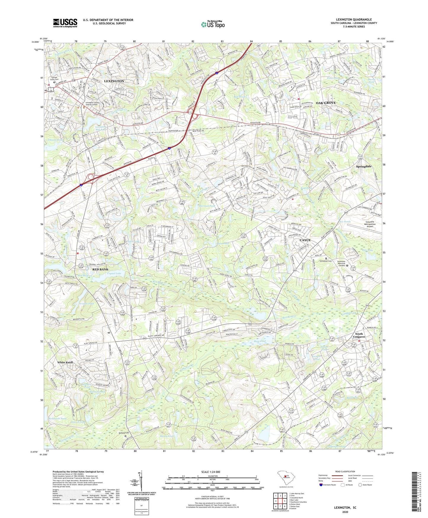
2020 topographic map quadrangle Lexington in the state of South Carolina. Scale: 1:24000. Based on the newly updated USGS 7.5' US Topo map series, this map is in the following counties: Lexington. The map contains contour data, water features, and other items you are used to seeing on USGS maps, but also has updated roads and other features. This is the next generation of topographic maps. Printed on high-quality waterproof paper with UV fade-resistant inks.
Quads adjacent to this one:
West: Barr Lake
Northwest: Lake Murray East
North: Irmo
Northeast: Columbia North
East: Southwest Columbia
Southeast: Gaston
South: Pelion East
Southwest: Pelion West
Contains the following named places: Airport Church, Amour Pond, Arrants Pond, Arthur, Arthur Fire Tower, Assembly of God Church, Baskin Hills, Bethany Cemetery, Bethany Lutheran Church, Blue Ridge Terrace, Calvary Church, Carroll Pond, Cedar Estates, Cedar Grove School, Cedarwood, Columbia Camp, Columbia Metropolitan Airport, Congaree, Congaree Elementary School, Congaree Gardens, Coventry Woods, Crystal Lake, Crystal View, Downtown Lexington Post Office, Dunns Chapel, Durham Pond, Dutchman Acres, Ebenezer Church, Eden Pond, Emmanuel Cemetery, Emmanuel Lutheran Church, Fisher Pond, George Gross Cemetery, Gibsons Pond, Greyland Forest, Hamlet South, Hamlet West, Harmon Pond, Harrisburg, Heritage Hills, Hillside, Hilltop Shopping Center, Honeywood, Hunt Pond, Indian Pines, Joel Church, Kings Grant, Lake Durham, Lake Matthew, Lakeview Terrace, Lakewood, Land of the Lakes, Lawn Pond, Lexington, Lexington County Courthouse, Lexington County Fire Service Oak Grove Station 9, Lexington County Fire Service Pine Grove Station 19, Lexington County Fire Service South Congaree Station 5, Lexington County Fire Service Station 10, Lexington County Fire Service Station 24, Lexington Elementary School, Lexington Intermediate School, Lexington Middle, Lexington Mill Pond, Lexington Mill Pond Dam, Lexington Station, Lexington Town Hall, Lexington Woods, Lick Fork Branch, Martin Pond, Melwood, Mount Hebron Church, Nazareth Church, Oak Crest, Oak Grove, Oak Grove Census Designated Place, Oak Grove Elementary School, Oak Grove Estates, Oakridge, Oakwood, Parkwood, Peachtree Acres, Pennsylvania Glass Sand Settling Pond, Pitts Lake, Platts Spring Church, Pole Branch, Price Ponds, Red Bank, Red Bank Census Designated Place, Red Bank Creek, Red Bank Elementary School, Red Bank Mill Pond, Redmonds Pond, Reedy Branch, Regency Square, Roof Pond, Rose Gardens, Ruff Ponds, Saint Davids Evangelical Lutheran Church, Saint James Church, Saint Paul Church, Saxe-Gotha Millpond, Scouter Branch, Shealy Pond, Shealys Pond, Shealys Pond Dam D-1718, Sherman Pond, Shuler, South Carolina Highway Patrol Troop 1 Post C, South Carolina Noname 32002 D-0960 Dam, South Carolina Noname 32004 D-0969 Dam, South Carolina Noname 32009 D-0961 Dam, South Carolina Noname 32010 D-0966 Dam, South Carolina Noname 32015 D-1719 Dam, South Carolina Noname 32028 D-0965 Dam, South Carolina Noname 32030 D-0959 Dam, South Carolina Noname 32031 D-0962 Dam, South Carolina Noname 32076 D-0963 Dam, South Carolina Noname 32091 D-0967 Dam, South Congaree, Southgate, Southland Memorial Gardens, Sox Ponds, Spring Hill, Sunny South School, Three Fountains, Three Fountains Plaza Shopping Center, Town of Lexington, Town of South Congaree, Vernett Pond, Village Shopping Center, Walnut Creek, White Knoll, White Knoll Census Designated Place, White Knoll School, Woodberry Plaza Shopping Center, Woodsen, Wrenwood, ZIP Codes: 29073, 29170