MyTopo
Southwest Columbia South Carolina US Topo Map
Couldn't load pickup availability
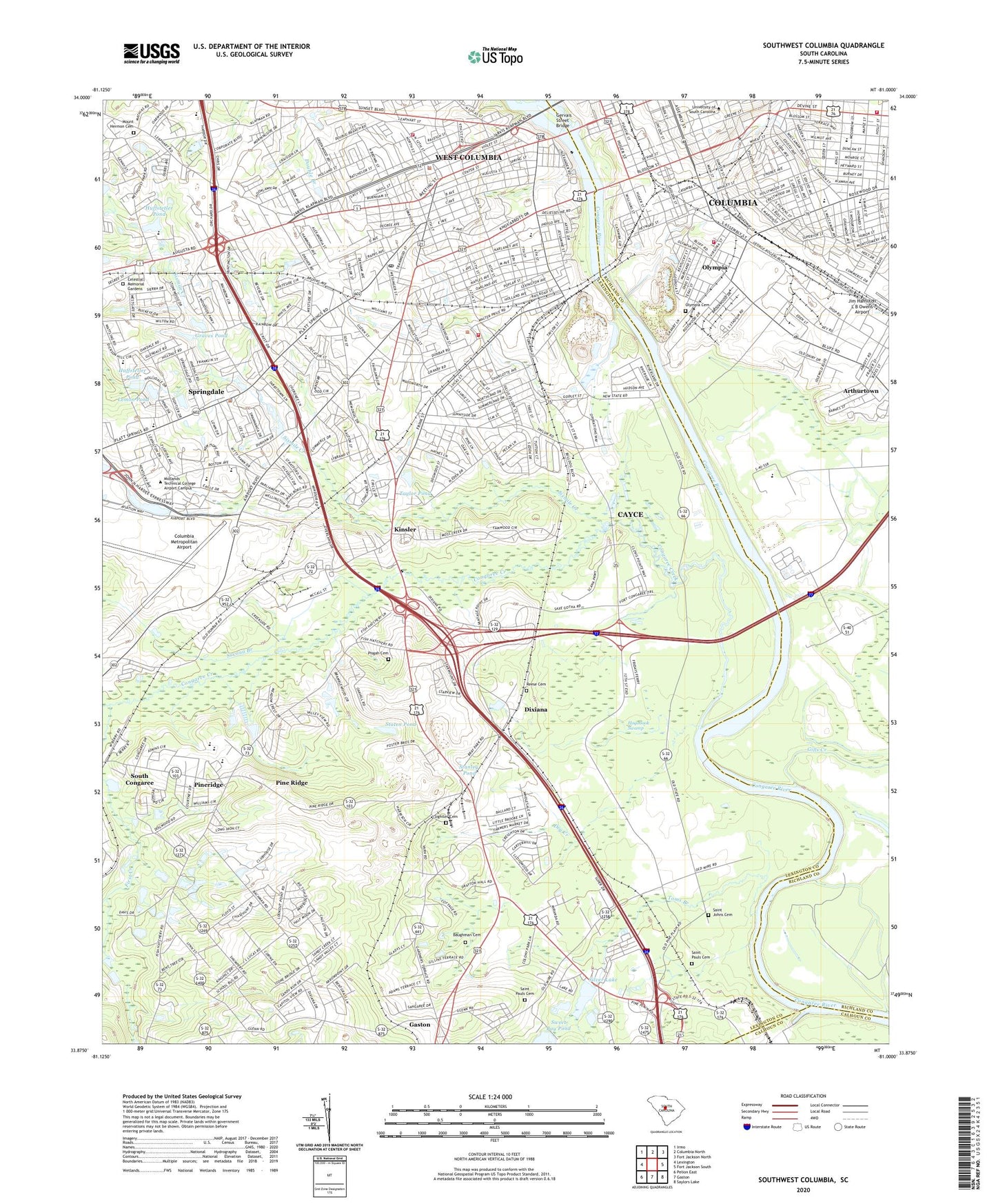
2020 topographic map quadrangle Southwest Columbia in the state of South Carolina. Scale: 1:24000. Based on the newly updated USGS 7.5' US Topo map series, this map is in the following counties: Lexington, Richland, Calhoun. The map contains contour data, water features, and other items you are used to seeing on USGS maps, but also has updated roads and other features. This is the next generation of topographic maps. Printed on high-quality waterproof paper with UV fade-resistant inks.
Quads adjacent to this one:
West: Lexington
Northwest: Irmo
North: Columbia North
Northeast: Fort Jackson North
East: Fort Jackson South
Southeast: Saylors Lake
South: Gaston
Southwest: Pelion East
Contains the following named places: Air South Industrial Park, Airport High School, American Creative School, Antioch Baptist Church, Apollo Gardens, Arborgate, Arthurtown, Arthurtown Census Designated Place, Augusta Street Presbyterian Church, Baptist Student Union, Barnwell College, Batesburg Reservoir Dam D-0928, Baughman Cemetery, Benson School, Bicentennial Park, Big Lake, Booker T Washington Animal Resource Facility, Booker T Washington Auditorium, Booker T Washington Center, Booker T Washington Child Care Center, Brookland - Cayce Grammar School Number 1, Brookland School, Brookland United Methodist Church, Brookland-Cayce High School, Brookland-Cayce School Number 2, Brookwood, Bull School, Busbee Middle School, Byrnes Building, C A Taylor Elementary School, Callcott Social Sciences Center, Camp Moore, Capitol Shopping Center, Carolina Coliseum, Carolina Plaza, Cayce, Cayce City Hall, Cayce Fire Department, Cayce Quarry, Cayce School, Celestial Memorial Gardens, Central Church of the Nazarene, Charwood, Charwood Golf Course, City of Cayce, City of West Columbia, Coker Life Sciences Building, Columbia - Richland Fire Department Olympia, Columbia - Richland Fire Department Shandon, Columbia Air Base, Columbia Quarry, Columbia Speedway, Columbia-Vocational School, Congaree Church, Congaree Creek, Currell Annex, Currell College, Danwood Shopping Center, Davis College, DeSaussure College, Dixiana, Dixiana Church, Drayton Hall, Dry Creek, Earl Davis Elementary School, East Campus Center, Edenwood, Edenwood Plaza Shopping Center, Elliott College, Emily Douglas Park, Fairhill, First Creek, Flinn Hall, Fulmer Junior High School, Gambrell Hall, Geiger Pond, Gervais Street Bridge, Gibbes Green, Gills Creek, Glenn Village, Grace Chapel, Granby Village Shopping Center, Grandview Estates, Graves Pond, Greene Street United Methodist Church, Guignard Park, Hamilton College, Hand Middle School, Happytown, Harbor Church, Harper College, Herbert A Wood Elementary School, Hogobook Swamp, Holiness Church, Hollywood, Hollywood Park, Horse Pond, Huffstetler Pond, Institute of Archaeology and Anthropology, Interstate Industrial Park, Ira and Nancy Koger Center for the Arts, James Chapel Methodist Episcopal Church, Jones Physical Science Center, Kibler Pond, Kinsler, Law Center, LeConte College, Legare College, Lemon Pond, Lexington Square Shopping Center, Lieber College, Lloydswoods, Long Branch School, Longstreet Annex, Longstreet Theatre, Maxcy Gregg Park, Maxy College, McBryde Quadrangle, McKissick Museum, Melton Observatory, Midlands Technical College - Airport Campus, Moore School, Mount Hermon Cemetery, Mount Pleasant Church, Mount Tabor Church, Mount Tabor Lutheran Church, Nazarene Tabernacle, New Brookland Historic District, New Dublin, Northside Middle School, Oakdale School, Oakhurst Park, Old Granby Landing, Old Observatory, Olympia, Olympia Cemetery, Olympia Census Designated Place, Olympia School, Opportunity School, Osborne Administration Building, Pacific Park, Pair School, Parkland Shopping Center, Parkway Place, Patterson Hall, Perrin-Thomas School, Petigru College, Pinckney College, Pine Ridge Middle School, Pineridge, Pineview School, Pisgah Cemetery, Preston College, Reese Cemetery, Rex Enright Athletic Center, River Bluff Estates, Rutledge College, Saint James Church, Saint Johns Cemetery, Saint Paul Church, Saint Paul School, Saint Pauls Cemetery, Saint Pauls Church, Savana Branch, Schneider School, Second Creek, Shadblow, Shandon, Sightler Cemetery, Silver Lake, Sixmile Creek, Sloan College, Solomon Blatt Physical Education Center, South Carolina Highway Patrol Troop 1 Post D, South Carolina Noname 32040 D-0991 Dam, South Carolina Noname 32041 D-0986 Dam, South Carolina Noname 32086 D-0987 Dam, South Carolina State Museum, South Carolina State Vocational Rehabilitation Center, South Carolina Vocational Rehabilitation Evaluation Center, South Caroliniana Library, South Tower, Springdale, Springdale Police Department, Springdale School, Stanley Pond, Starmount, Staten Pond, Styx, Styx State Fish Hatchery, Swearingen Engineering Center, Sweet Bay Pond, Taylor Pond, The Horseshoe, Thomas Cooper Library, Thomson Student Health Center, Thornwell College, Toms Branch, Town and Country Shopping Center, Town of Pine Ridge, Town of Springdale, University of South Carolina, Wales Garden, Wardlaw College, Washington High School, Welsh Humanities Building, West Columbia, West Columbia Baptist Church, West Columbia City Hall, West Columbia Fire Department, West Columbia Full Gospel Tabernacle, West Columbia Police Department, West Columbia Post Office, West Columbia Presbyterian Church, West Columbia-Cayce Division, West End Square Shopping Center, West Gervais Street Historic District, Westcliff Estates, Westgate, Westside Plaza Shopping Center, Westwood, Westwood Church, Williams-Brice Stadium, WOIC-AM (Columbia), Woodrow College, World War Memorial, WTGH-AM (Cayce), WYFV-FM (Cayce), ZIP Codes: 29033, 29169, 29172, 29201, 29202, 29208, 29225