MyTopo
Gordonsburg Tennessee US Topo Map
Couldn't load pickup availability
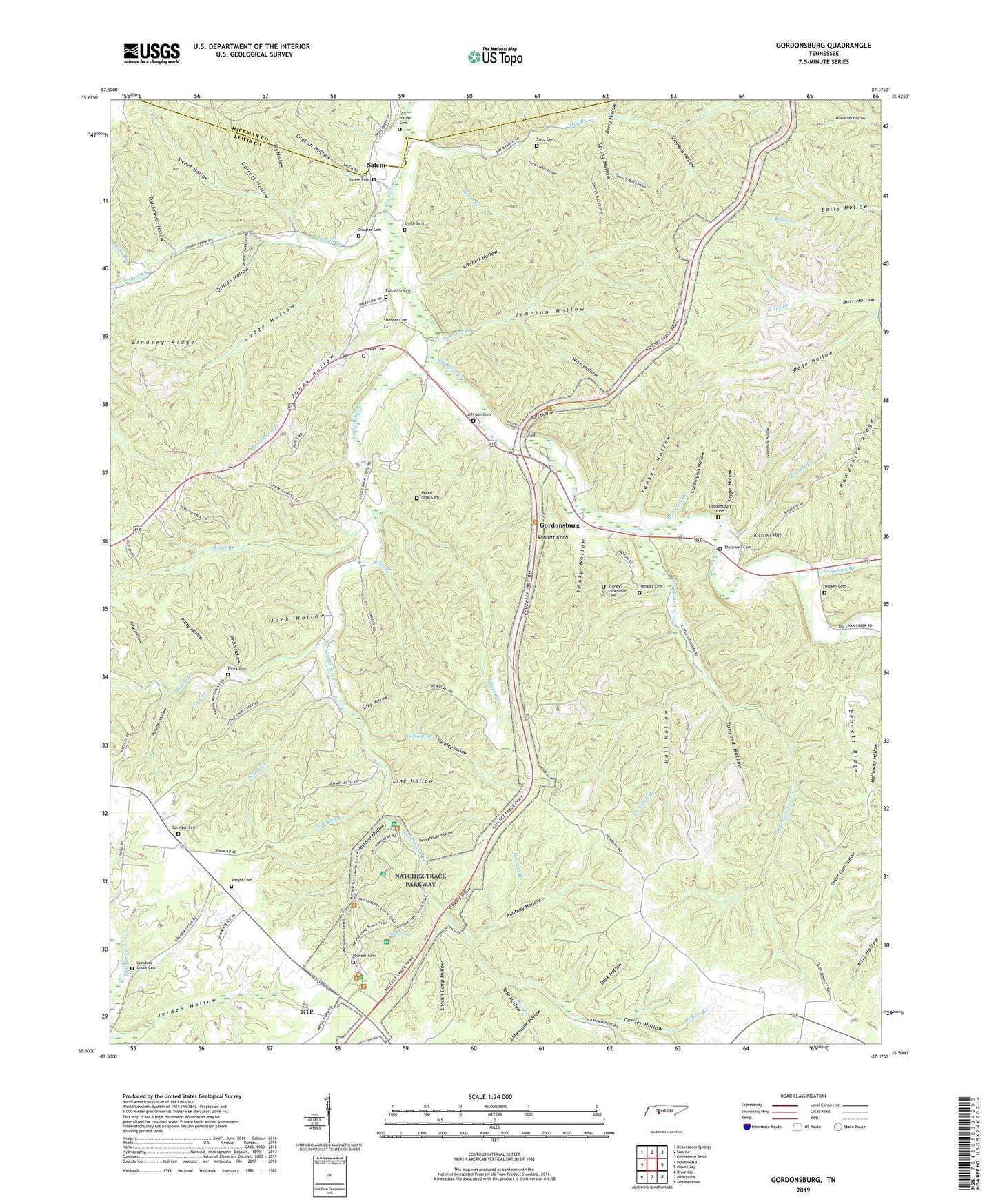
2019 topographic map quadrangle Gordonsburg in the state of Tennessee. Scale: 1:24000. Based on the newly updated USGS 7.5' US Topo map series, this map is in the following counties: Lewis, Hickman. The map contains contour data, water features, and other items you are used to seeing on USGS maps, but also has updated roads and other features. This is the next generation of topographic maps. Printed on high-quality waterproof paper with UV fade-resistant inks.
Quads adjacent to this one:
West: Hohenwald
Northwest: Beaverdam Springs
North: Sunrise
Northeast: Greenfield Bend
East: Mount Joy
Southeast: Summertown
South: Henryville
Southwest: Riverside
Contains the following named places: Anderson Branch, Auntney Hollow, Beech Branch, Bennett Ridge, Berry Hollow, Big Siding, Black Branch, Blackwell Cemetery, Bradford Hollow, Briar Branch, Brush Creek, Brush Creek School, Burl Hollow, Cade Branch, Carrol Bank Prospect, Collier Branch, Collier Hollow, Commissioner District 2, Cubbington Hollow, Cudge Hollow, Dark Hollow, Dedin Hollow, Douglas Cemetery, Dry Branch, Dyestone Hollow, Eel Branch, Eel Branch Prospect, English Camp Hollow, English Hollow, Fall Branch, Fall Hollow, Faucette Hollow, Flat Woods, Garrett Hollow, Georgia Branch, Gordonsburg, Gordonsburg Cemetery, Gordonsburg Church of Christ, Greenbriar Hollow, Grinders Creek Cemetery, Grinders Inn, Harder Cemetery, Hartley Branch, Hartley Branch Prospect, Hensley Cemetery, Hensley Hollow, Hick Hill Branch, Hog Hollow, Indian Creek, Indian Creek School, Jack Hollow, Jagger Hollow, Jerden Hollow, Joby Hollow, Johnson Cemetery, Johnson Hollow, Jones Hollow, Kittrell Branch, Kittrell Hill, Langford Branch, Lewis County, Lewis Park, Limestone Hollow, Lindsey Ridge, Line Hollow, Little Grinders Creek, Little Swan Church, Little Swan Creek, Low Gap Branch, Low Gap Branch Prospect Number One, Low Gap Branch Prospect Number Two, Lyon Prospect, Mall Hollow, Meriwether Lewis National Monument, Mitchell Hollow, Mount Sinai Cemetery, Mount Sinai Church, Natchez Trace Prospect, Newburg, Old Harder Cemetery, Old Spring, Palestine, Palestine Cemetery, Panther Hollow, Peavyhouse Hollow, Perismmon Branch, Piney Branch, Piney Cemetery, Pioneer Cemetery, Plazy Hollow, Quillen Hollow, Rabbitt Knob, Rhodes Cemetery, Rocky Branch, Salem, Salem Cemetery, Sammies Branch, Silky Hollow, Simmons Hollow, Sisco Cemetery, Smith Cemetery, Smoky Hollow, Spring Hollow, Springer Cemetery, Springer Ridge, Springer Ridge Church, Stockard Prospect, Stoney- Lonesome Cemetery, Suck Branch, Sugarcamp Hollow, Swan Valley Overlook, Sweet Hollow, Tanyard Hollow, Tate Branch, Tate Hollow, Touchmenot Hollow, Wade Hollow, Walker Cemetery, Wilson Branch - Cade Branch Prospect, Wiss Hollow, Wright Cemetery, Yankee Hollow