
MyTopo
Manchester Tennessee US Topo Map
Couldn't load pickup availability
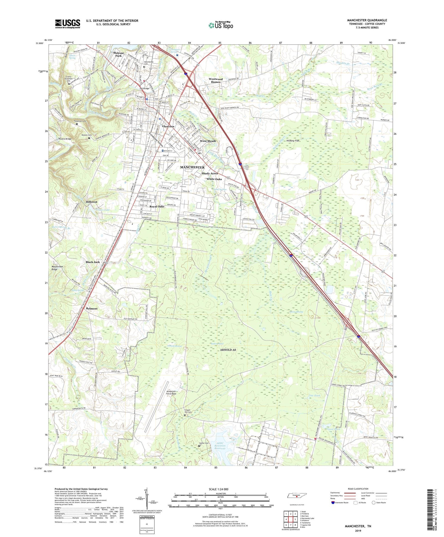
2019 topographic map quadrangle Manchester in the state of Tennessee. Scale: 1:24000. Based on the newly updated USGS 7.5' US Topo map series, this map is in the following counties: Coffee. The map contains contour data, water features, and other items you are used to seeing on USGS maps, but also has updated roads and other features. This is the next generation of topographic maps. Printed on high-quality waterproof paper with UV fade-resistant inks.
Quads adjacent to this one:
West: Normandy Lake
Northwest: Noah
North: Fredonia
Northeast: Morrison
East: Hillsboro
Southeast: Alto
South: Capitol Hill
Southwest: Tullahoma
Contains the following named places: AEDC Retention Reservoir, AEDC Retention Reservoir Dam, AEDC Water Tank, Allison Spring, Arnold Air Force Base, Arnold Engineering Development Center Fire Department, Bains Orchard, Bashaw Creek, Belmont, Big Falls, Black Jack, Bluehole Falls, Brushy Branch School, Bushy Branch Church, Center View School, Central High School, Chapel Hill Cemetery, Church of Christ, Church of God, City of Manchester, Coffee County, Coffee County Central High School, Coffee County Court House, Coffee County EMS, Coffee County Health Department, Coffee County High School, Coffee County Sheriff's Office, College Street Elementary School, Commissioner District 1, Commissioner District 14, Commissioner District 2, Commissioner District 3, Commissioner District 4, Commissioner District 6, Cow Pond, Crestwood Rest Home, Dark Hollow, Dixie, Doak Springs, Faith Freewill Baptist Church, First Baptist Church, First Church of the Nazarene, Glenview, Goodman Spring, Goodman Spring Branch, Goose Pond, Goose Pond Swamp, Grace Baptist Church, Granny Hickerson Cemetery, Green Acres Mobile Home Park, Grindstone Hollow, Hickerson Cemetery, Hickory Flat, Hickory Flat Creek, Hillcrest, Huckleberry Creek, Huckleberry Creek Dam, Huffar Cemetery, Hunt Creek, Hunt Creek Dam, Jail Bridge, Lemm Swamp, Little Duck River, Little Falls, Logan Chapel School, Manchester, Manchester Cemetery, Manchester City Hall, Manchester Cumberland Presbyterian Church, Manchester Division, Manchester Fire and Rescue Department, Manchester Fire and Rescue Department Station 2, Manchester First Freewill Baptist Church, Manchester First Presbyterian Church, Manchester First United Methodist Church, Manchester Golf and Country Club, Manchester Male and Female College, Manchester Police Department, Manchester Post Office, Manchester School, Manchester Shopping Center, Manchester United Pentacostal Church, Medical Center Shopping Center, Melrose Park, Morton Dam, Morton Lake, Mount View Church, National Plaza Shopping Center, Oak Hill Seminary, Oak Plaza Shopping Center, Old Hills Chapel Church, Old Stone Fort, Old Stone Fort State Park, Powers Bridge, Powers Shopping Center, Ragsdale Church, Ragsdale Road Mobile Home Park, Red Hill Church, Red Hill School, Roan Buck Branch, Royal Oaks, Saint Bedes Church, Seminary Hill School, Shady Acres, Shady Grove Mobile Home Park, Shanklin Branch, Sinking Pond, Southside Church of Christ, Southtown Center Shopping Center, Stacey Anns Mobile Home Park, Stephen Chapel United Methodist Church, Sulphur Spring, Taylor Branch, Temple Baptist Church, Toliver Lake, Toliver Lake Dam, Trinity Baptist Church, United Regional Medical Center, Unity Medical Center, West Meade, Westall Swamp, Westwood, Westwood Baptist Church, Westwood Elementary School, Westwood Homes, Westwood Junior High School, White Oaks, Wiley Spring, WMSR-AM (Manchester), WMSR-FM (Manchester), Wolf Creek, Wooten Cemetery, ZIP Code: 37355


