MyTopo
New Providence Tennessee US Topo Map
Couldn't load pickup availability
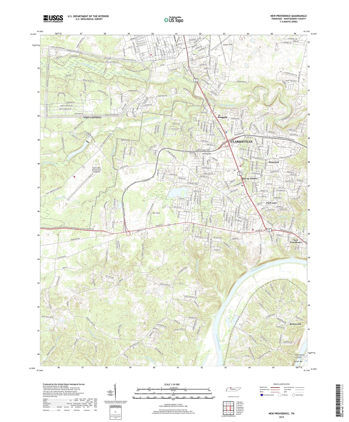
2019 topographic map quadrangle New Providence in the state of Tennessee. Scale: 1:24000. Based on the newly updated USGS 7.5' US Topo map series, this map is in the following counties: Montgomery. The map contains contour data, water features, and other items you are used to seeing on USGS maps, but also has updated roads and other features. This is the next generation of topographic maps. Printed on high-quality waterproof paper with UV fade-resistant inks.
Quads adjacent to this one:
West: Woodlawn
Northwest: Herndon
North: Oak Grove
Northeast: Trenton
East: Clarksville
Southeast: Excell
South: Palmyra
Southwest: Needmore
Contains the following named places: Bel Air Park, Bel-Air Estates, Belle Forest, Belleglade, Boxcroft, Boyd Acres, Brentwood, Briarwood, Briarwood Church, Briarwood School, Byrns Darden Elementary School, Camp Tagaytay, Cave Spring, Cedargold, Clarksville Base Physical Fitness Center, Clarksville Fire Rescue Department Station 5, Clarksville Fire Rescue Department Station 6, Clarksville Police Department District 1, Cole Park Golf Course, Commissioner District 11, Commissioner District 12, Commissioner District 16, Commissioner District 9, Countrybrook, Cumberland Heights Elementary School, Cummingham Bridge, Cunningham Bridge, Dale Terrace, Darnell Estates, District 3, District 7, District 8, Donaldson Creek, Fletchers Fork, Fort Campbell Department of Defense Fire Department Station 1, Fort Campbell Department of Defense Fire Department Station 2, Fort Campbell Division, Fountainbleau, Gate Number One, Gate Number Two, Geiser Bar, Hermitage Estates, Johnson Heights, Kenwood, Kenwood Baptist Church, Kleenman Community Center, Lake Taal, Lake Taal Dam, Liberty Church, Lintwood Heights, Linwood Landing, Little West Fork Church, Louise Heights, Meadowbrook, Millswood Estates, Montgomery County Vocational Technical School, Montgomery Estates, Morrison Estates, Mount Pisgah Church, Mount Pleasant Church, New Providence, New Providence Middle School, New Providence Post Office, New Providence Recreation Area, North Haven, North Park, Northwest High School, Northwood Terrace, Oakland Heights, Ogburn Chapel, Outlaw Field, Park Lane, Parr Field, Peachers Mill, Raccoon Branch, Ranch Hill, Ringgold, Ringgold Acres, Ringgold Creek Mill, Ringgold Elementary School, Ringgold Mill Post Office, Rosehill Estates, Sabre Army Airfield (Fort Campbell), Sherwood Forest, Southaven, Story Book Acres, Sunnyview Church, Tradewinds North Shopping Center, Trice Landing, Walnut Grove Church, West Fork Hills, White Hall, Wilmouth School, Woodlawn Estates, Woodlawn School, ZIP Code: 37042