MyTopo
Norris Tennessee US Topo Map
Couldn't load pickup availability
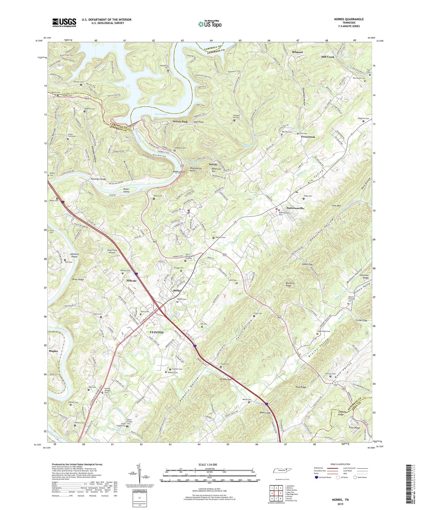
2019 topographic map quadrangle Norris in the state of Tennessee. Scale: 1:24000. Based on the newly updated USGS 7.5' US Topo map series, this map is in the following counties: Anderson, Campbell, Knox. The map contains contour data, water features, and other items you are used to seeing on USGS maps, but also has updated roads and other features. This is the next generation of topographic maps. Printed on high-quality waterproof paper with UV fade-resistant inks.
Quads adjacent to this one:
West: Lake City
Northwest: Jacksboro
North: Demory
Northeast: White Hollow
East: Big Ridge Park
Southeast: Fountain City
South: Powell
Southwest: Clinton
Contains the following named places: Anderson County Occupational Development School, Andersonville, Andersonville Cemetery, Andersonville Census Designated Place, Andersonville Elementary School, Andersonville Post Office, Andersonville Volunteer Fire Department Station 1, Andy Branch, Belmont, Belmont School, Bethel, Bethel Baptist Cemetery, Bethel Baptist Church, Big Valley, Bluebird Lookout Tower, Bluebird Ridge, Brooks Gap, Brushy Creek, Buffalo Creek, Buffalo Valley, Burris Cemetery, Byrams Fork, Carden Gap, City of Norris, Civilian Conservation Corps Camp Number, Civilian Conservation Corps Camp Number 4493, Civilian Conservation Corps Camp Number 4495, Clear Cemetery, Clear Creek, Clear Creek Spring, Clear Spring, Coal Creek, Commissioner District 3, Cove Creek, Cox Cemetery, Dark Hollow, Davis Cemetery, Deer Trail, Disney Cemetery, District 13, District 2, District 3, Fairview Baptist Church, Fairview Cemetery, Fairview Elementary School, Foust Cemetery, Foust Hollow, Fox Mill, Gibbs Cemetery, Glen Alpine Junior High School, Gooseneck, Gooseneck Hollow, Harmon Cemetery, Hart Cemetery, Hawkins Cemetery, Heavenly Hollow, Hibbs Island, Hickory Valley, High Point, Hillvale, Hillvale Baptist Church, Hillvale Cemetery, Hinds Creek, Hinds Creek Baptist Church, Indian Gap, Indian Gap Church, Irwin Cemetery, Island Ford, Island Ford Baptist Church, Island Ford Cemetery, Island Home Baptist Church, Ivory, John Creek, Johnsons Shoals, Lenoir Museum, Liberty Church, Lone Mountain, Lone Mountain Church, Lone Mountain School, Longmire Cemetery, Lovely Mill, Loys Mill, Macedonia Baptist Church, Macedonia Cemetery, Macedonia Church, Maples, Massengill Bridge, Massengill Hollow, Mill Creek, Miller Cemetery, Miller Hollow, Miller Island, Miller Spring, Moore Cemetery, Moore Gap, Moores Gap Methodist Church, Mount Pleasant Baptist Church, Mount Pleasant Baptist Church Cemetery, Museum of Appalachia, Nelson Spring, New Home Cemetery, New Home Missionary Baptist Church, Norris, Norris Aquatic Center, Norris Dam, Norris Dam State Park, Norris Division, Norris Elementary School, Norris Evaporation Station, Norris Fire Department, Norris Forestry Research Area, Norris Memorial Gardens, Norris Middle School, Norris Municipal Park, Norris Park, Norris Police Department, Norris Post Office, Norris Town Forest, Oak Grove Cemetery, Observation Point, Old Red Hill Cemetery, Overton Cemetery, Panther, Pumpkin Hollow, Pyle Cemetery, Red Hill Baptist Church, Red Hill Cemetery, Reservoir Hill, Riner Farm Airport, River Bluff Small Wild Area, River Bluff Trail, River Ridge, Riverview School, Roberts Cemetery, Ross Cemetery, Scenic Woods, Scruggs Cemetery, Sequoyah Dock, Sinking Springs Cemetery, Sinking Springs United Methodist Church, Strong Hollow, Taylor Chapel Cemetery, Underwood Cemetery, Wallace Cemetery, Wallace Cemetery Number 3, West Overlook, Whitaker Hollow, Williams Spring, ZIP Codes: 37705, 37754, 37828