MyTopo
Standing Rock Tennessee US Topo Map
Couldn't load pickup availability
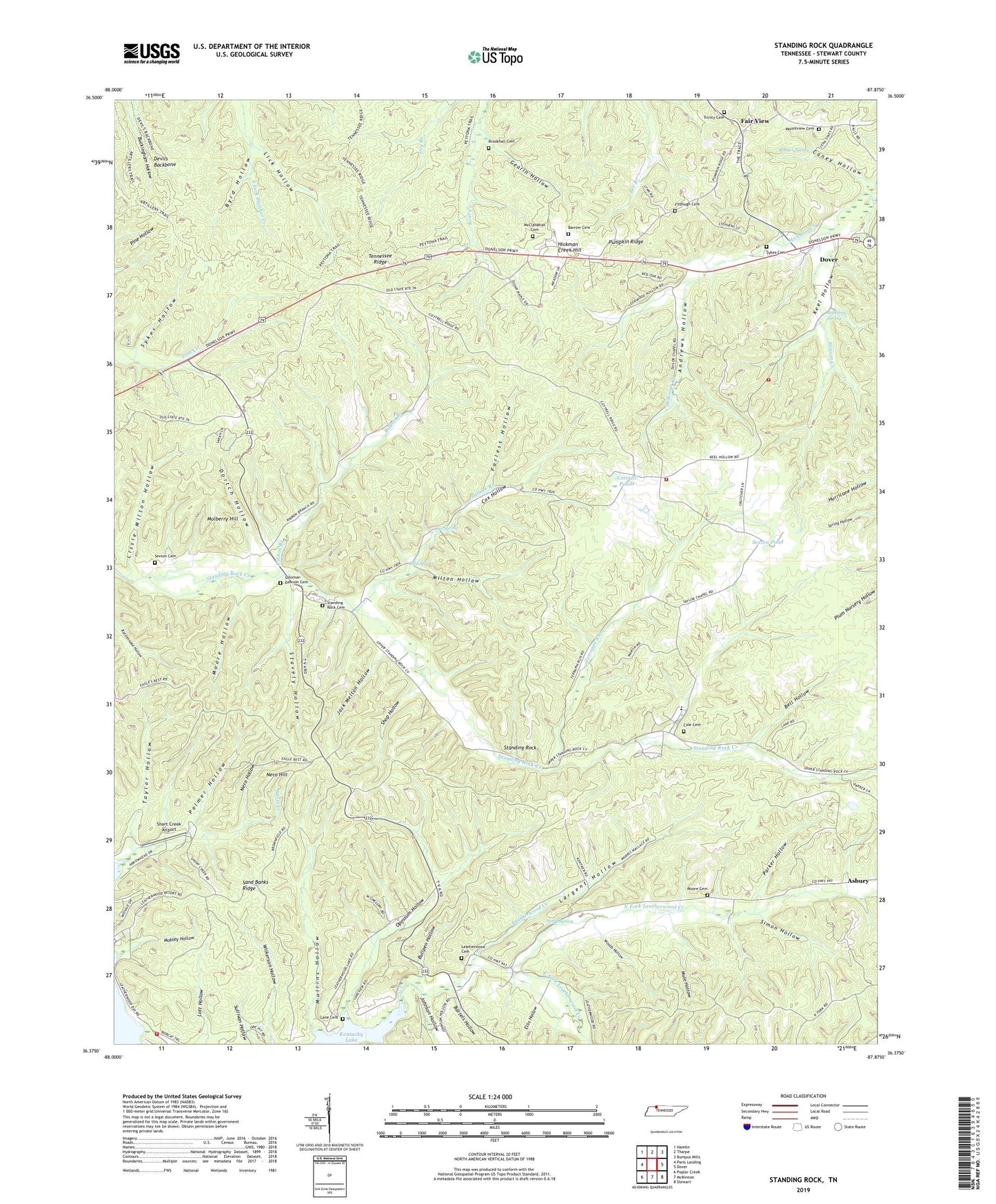
2019 topographic map quadrangle Standing Rock in the state of Tennessee. Scale: 1:24000. Based on the newly updated USGS 7.5' US Topo map series, this map is in the following counties: Stewart. The map contains contour data, water features, and other items you are used to seeing on USGS maps, but also has updated roads and other features. This is the next generation of topographic maps. Printed on high-quality waterproof paper with UV fade-resistant inks.
Quads adjacent to this one:
West: Paris Landing
Northwest: Hamlin
North: Tharpe
Northeast: Bumpus Mills
East: Dover
Southeast: Stewart
South: McKinnon
Southwest: Poplar Creek
Contains the following named places: Andrews Hollow, Asbury, Asbury School, Barrow Cemetery, Bartels Hollow, Bell Hollow, Brookhall Cemetery, Bubbling Spring, Bullpen Hollow, Byrd Hollow, Caney Hollow, Clark Furnace, Clark Furnace Mines, Cold Spring, Cole Cemetery, Commissioner District 5, Cottrell Ponds, Cox Hollow, Cox Spring, Cross Roads, Devils Backbone, Dortch Hollow, Dover - Stewart County Rescue Squad, East Fork Leatherwood Creek, Ellis Hollow, Fair View, Fairview School, Farless Hollow, Fitzhugh Cemetery, Gearin Hollow, Hickman Creek Hill, Hinson Creek, Jack Melton Hollow, Johnson Hollow, Keel Hollow, Lane Cemetery, Largent Hollow, Leatherwood Cemetery, Leatherwood Church, Leatherwood Dock, Lick Hollow, Lissie Milton Hollow, McClanahan Cemetery, McGee Chapel, McGee School, Midway School, Milton Hollow, Mobley Hollow, Moore Cemetery, Moore Hollow, Mountview Cemetery, Mountview Church, Mud Bank Mine, Mulberry Hill, Mulberry Hill School, Mule Hollow, Mullins Hollow, Nero Hill, Nero Hollow, North Fork Leatherwood Creek, Old Tunnel Mine, Opossum Hollow, Palmer Branch, Palmer Hollow, Parker Hollow, Pearl Spring, Peytonia Furnace, Pumpkin Ridge, Ribbon Branch, Roeder Spring, Sand Banks Ridge, Sexton Cemetery, Sexton Pond, Shop Hollow, Short Creek Airport, Simon Hollow, Soloman Dawson Cemetery, Standing Rock, Standing Rock Cemetery, Standing Rock Church, Stavely Hollow, Stewart County Fire Rescue Station 4, Stewart County Fire Rescue Station 9, Sykes Cemetery, Sykes Hollow, Taylor Chapel, Taylor Chapel School, Taylor Hollow, Terrapin Run, Trinity Cemetery, Trinity United Methodist Church, Woods Hollow, ZIP Code: 37058