MyTopo
Watauga Dam Tennessee US Topo Map
Couldn't load pickup availability
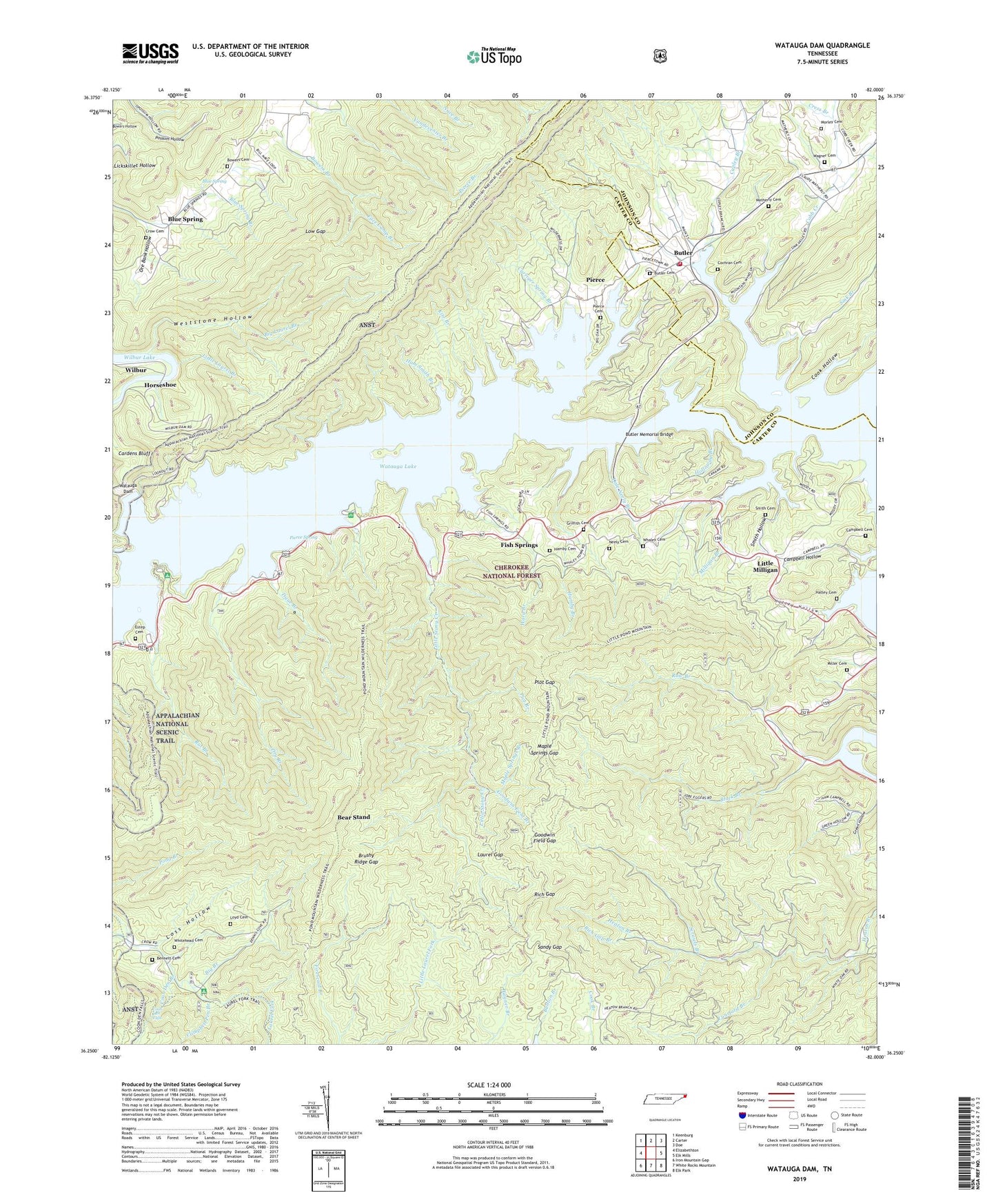
2019 topographic map quadrangle Watauga Dam in the state of Tennessee. Scale: 1:24000. Based on the newly updated USGS 7.5' US Topo map series, this map is in the following counties: Carter, Johnson. The map contains contour data, water features, and other items you are used to seeing on USGS maps, but also has updated roads and other features. This is the next generation of topographic maps. Printed on high-quality waterproof paper with UV fade-resistant inks.
Quads adjacent to this one:
West: Elizabethton
Northwest: Keenburg
North: Carter
Northeast: Doe
East: Elk Mills
Southeast: Elk Park
South: White Rocks Mountain
Southwest: Iron Mountain Gap
Contains the following named places: Bear Stand, Bennett Cemetery, Big Branch, Big Laurel Branch, Big Laurel Branch Wilderness, Black Branch, Blue Spring, Blue Spring Church, Blue Spring Mine, Blue Springs School, Bowers Branch, Bowers Branch Prospect, Bowers Cemetery, Bowers Mine, Brushy Ridge Gap, Bunton Ridge, Butler, Butler Baptist Church, Butler Cemetery, Butler Census Designated Place, Butler Memorial Bridge, Butler Post Office, Butler Volunteer Fire Department, Campbell Cemetery, Campbell Chapel, Campbell Pen Branch, Capley Branch, Cardens Bluff, Cardens Bluff Campground, Cardens Bluff Mine, Cardens Bluff School, Carriger Spring Branch, Cobb Creek, Cobb Creek Prospect, Cobb Creek School, Cochran Cemetery, Commissioner District 6, Cook Hollow, Cook Ridge, Coon Den Branch, Coon Den Falls, Copley Branch, Cove Ridge, Cove Ridge Dock, Cress Branch, Crow Cemetery, Dale Neely Branch, Dennis Cove, Dennis Cove Campground, Dennis Cove School, Dry Branch, Dubault Prospect, Elk Mine, Elk River Church, Estep Cemetery, Face Camp Branch, Firescald Knob, Fish Springs, Fish Springs Baptist Church, Fish Springs Dock, Flat Ridge, Freewill Church, Gipson Mountain, Goodwin Field Branch, Goodwin Field Gap, Gouge, Griffith Cemetery, Ham Smith Branch, Hamby Branch, Hamby Cemetery, Hanks Boat Dock, Hatley Cemetery, Hatley Hollow, High Health, Holloway Branch, Horseshoe, Horseshoe School, Ingram Hill, Kite Branch, Lakeshore Dock, Larsens Landing, Laurel Fork Division, Laurel Fork Wildlife Management Area, Laurel Gap, Lineback, Little Laurel Branch, Little Milligan, Little Milligan Baptist Church, Little Milligan Boating Site, Little Milligan Elementary School, Little Pond Mountain, Little Pond Mountain Trail, Little Stony Creek, Little Walnut Ridge, Loss Hollow, Low Gap, Lunsford Branch, Maple Springs Branch, Maple Springs Gap, Matherly Cemetery, Mays Ridge, Miller Cemetery, Miller Chapel, Milligan Branch, Morley Cemetery, Neely Cemetery, Nidiffer Chapel, Ore Bank Hollow, Peavey Mountain, Pierce, Pierce Branch, Pierce Cemetery, Pierce School, Pierce Spring, Pleasant Hill Church, Plot Branch, Plot Gap, Pond Mountain, Pond Mountain Trail, Pond Mountain Wilderness, Rat Branch, Rat Branch Boating Site, Rich Gap, Rich Gap Branch, Rough Ridge, Row Branch, Sandy Gap, Scrawls Branch, Scrawls Ridge, Sheffield Ridge, Sink Branch, Smith Cemetery, Smith Hollow, Smitty Branch, The Divide, Tigue Branch, Timbered Ridge, Wagner Cemetery, Walnut Mountain, Walnut Mountain Church, Ward Branch, Watauga Dam, Watauga Lake, Watauga Lakeshores Resort, Watauga Point Recreation Area, Watauga Point Recreational Area, Watauga Scenic Area, Watauga School, Weststone Hollow, Whaley Cemetery, White Hollow, Whitehead Cemetery, Whiting, Wilbur, Wilbur Lake, Younce Prospect, YS Men Picnic Area