MyTopo
Southeast Midland Texas US Topo Map
Couldn't load pickup availability
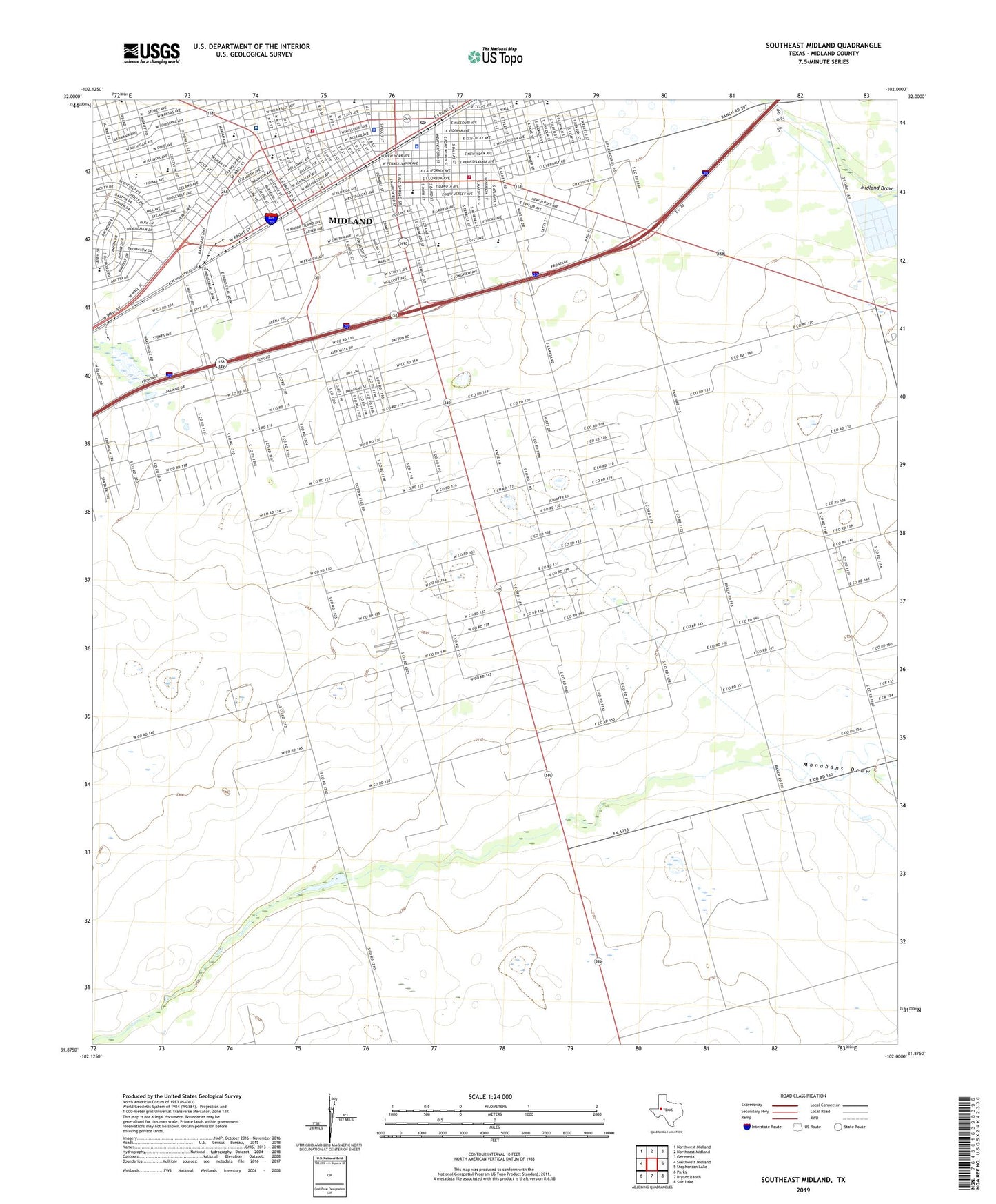
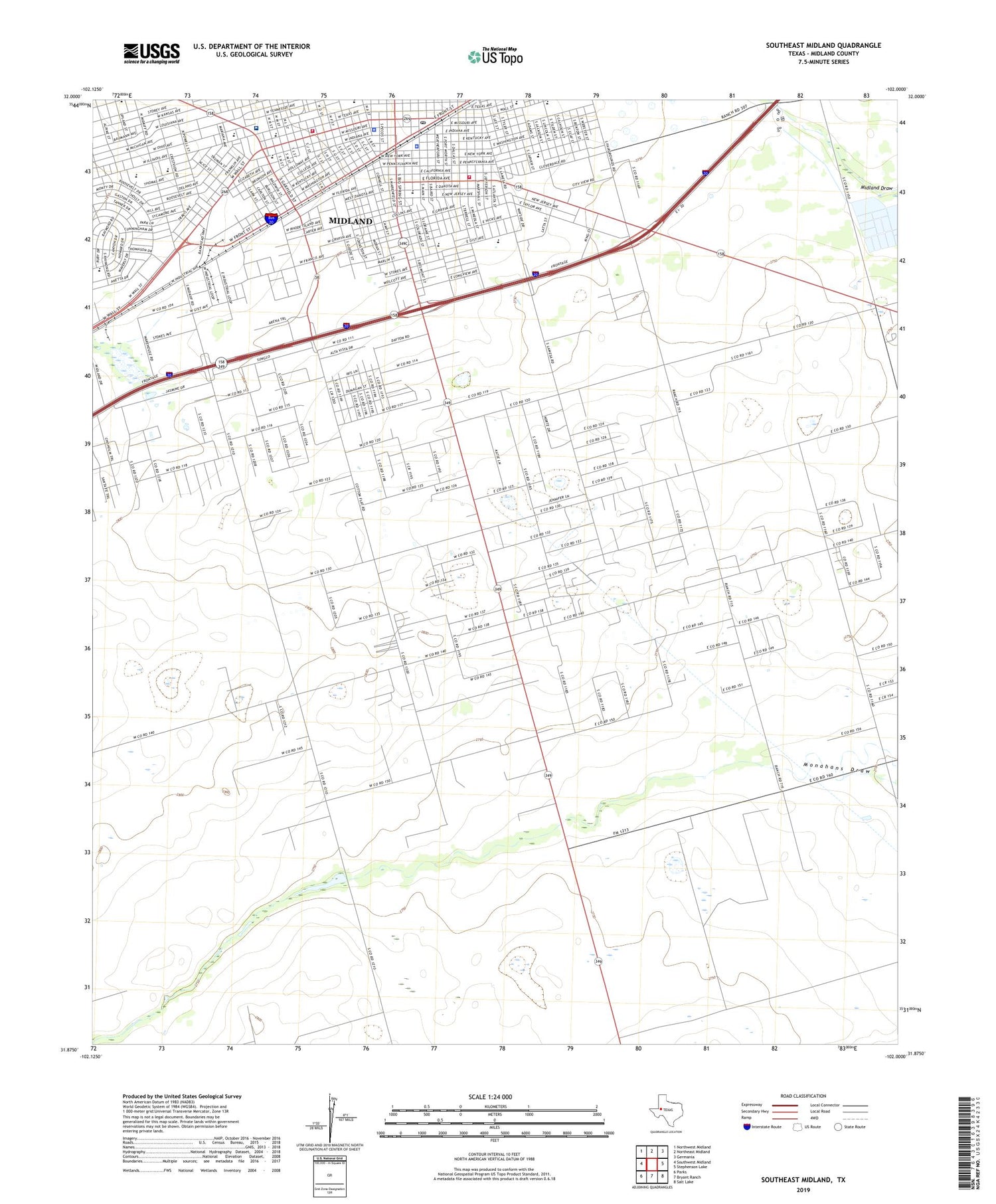
2019 topographic map quadrangle Southeast Midland in the state of Texas. Scale: 1:24000. Based on the newly updated USGS 7.5' US Topo map series, this map is in the following counties: Midland. The map contains contour data, water features, and other items you are used to seeing on USGS maps, but also has updated roads and other features. This is the next generation of topographic maps. Printed on high-quality waterproof paper with UV fade-resistant inks.
Quads adjacent to this one:
West: Southwest Midland
Northwest: Northwest Midland
North: Northeast Midland
Northeast: Germania
East: Stephenson Lake
Southeast: Salt Lake
South: Bryant Ranch
Southwest: Parks
Contains the following named places: Asbury United Methodist Church, Bethel Missionary Baptist Church, Brown-Dorsey House, Bryant Windmill, BTA Heliport, Bunche Early Childhood Center, Bunche School, Burnet Elementary School, Burnet School, Carver Elementary School, Carver High School, Cole Park, Cornerstone Church of God in Christ, Cotton Flat, Cotton Flat Church, Cowden Junior High School, Crestview Baptist Church, Crier Park, Cuthbert and Austin Church of Christ, Cuthbert Avenue Baptist Church, Dellwood Baptist Church, Dennis the Menace Park, Dunagan Park, East Side Church of Christ, Elkin Park, Episcopal Church of the Holy Trinity, Faith Tabernacle Apostolic Church, First Baptist Church, First Baptist Church Mission House, Fred and Juliette Turner House, Garrett Brown Park, Goodwill Baptist Church, Greater Mount Zion Baptist Church, Greater New Hope Baptist Church, Greater Saint John Baptist Church, Haley Park, Halff Park, Houston Elementary School, KBAT-FM (Midland), KJBC-AM (Midland), KMND-AM (Midland), KQRX-FM (Midland), KWEL-AM (Midland), KWHU-FM (Midland), Lamar Elementary School, Lamar School, Lancaster Park, Latin Free Methodist Church, Middle West Windmill, Middle Windmill, Midland, Midland City Hall, Midland County Constable's Office Precinct 1, Midland County Constable's Office Precinct 2, Midland County Constable's Office Precinct 3, Midland County Constable's Office Precinct 4, Midland County Historical Museum, Midland County Jail, Midland County Sheriff's Office, Midland Excel Campus, Midland Fire Department Central Fire Station, Midland Fire Department Harris Field Fire Training Facility, Midland Fire Department Station 2, Midland Freshman High School, Midland High School, Midland Independent School District Police Department, Midland Memorial Hospital, Midland Post Office Downtown Station, Midland Sewage Disposal Ponds, Museum of the Southwest, New Well Windmill, Nita Stewart Haley Memorial Library, Number Two Windmill, Our Lady de San Juan Catholic Church, Permian Basin Petroleum Museum, Rattlesnake Raceway, Ridgeheights, Saint Ann School, Saint Anns Catholic Church, Saint Luke's United Methodist Church, Sandy Acres, Second Baptist Church, Seventh Day Adventist Church, South Elementary School, South Memorial Baptist Church, South School, Tall City Baptist Church, Taylor Park, Terrace Gardens Nursing Home, Tower Church, Travis Baptist Church, Travis Elementary School, Travis School, Trinity Presbyterian Church, Ulmer Park, United Methodist Church Saint Lukes, Village Post Office, Walcott Windmill, Washington Elementary School, Washington Park, Washington School, West Early Childhood Center, West Kentucky Baptist Church, West School, ZIP Code: 79701