
MyTopo
Montpelier Vermont US Topo Map
Couldn't load pickup availability
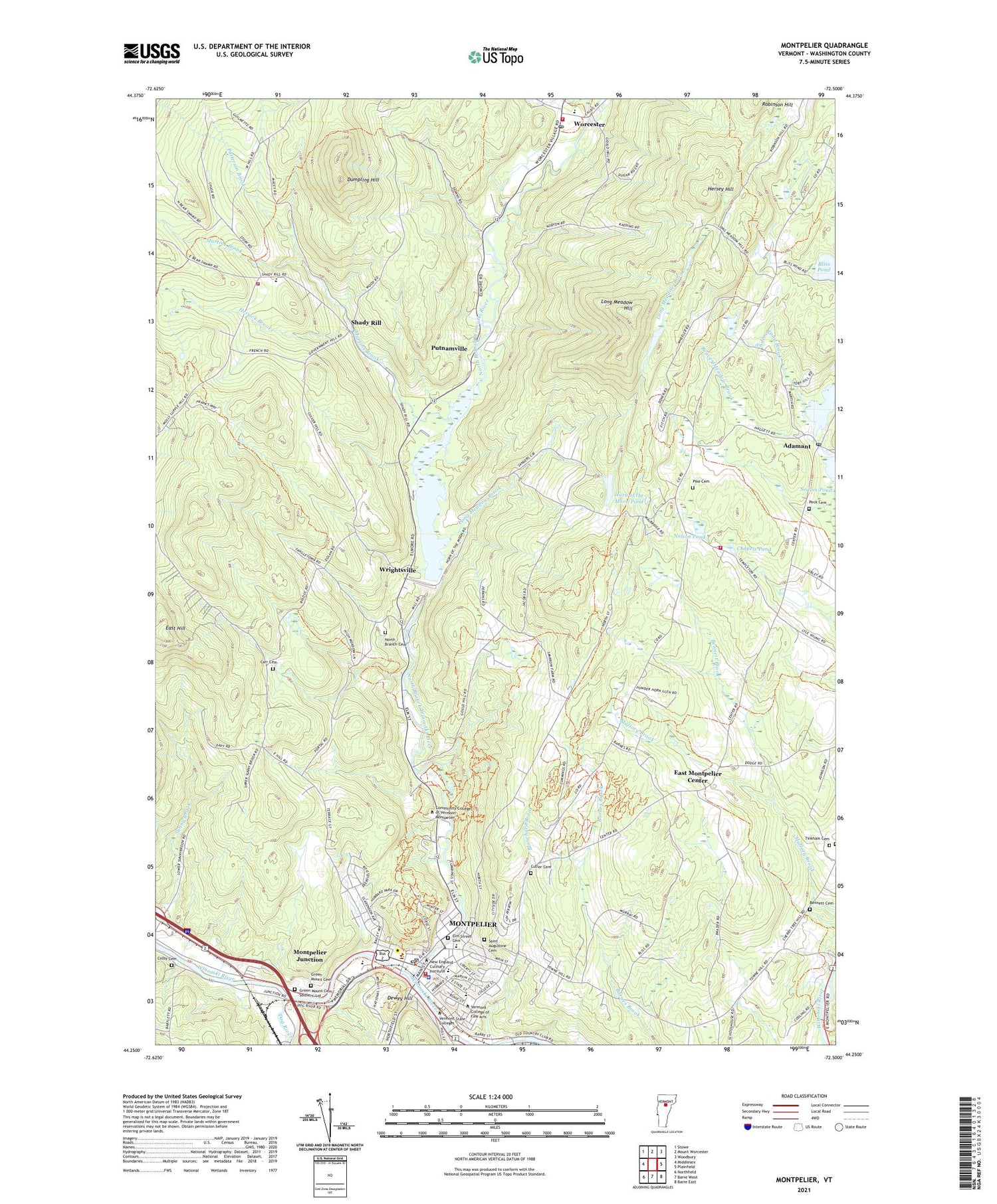
2021 topographic map quadrangle Montpelier in the state of Vermont. Scale: 1:24000. Based on the newly updated USGS 7.5' US Topo map series, this map is in the following counties: Washington. The map contains contour data, water features, and other items you are used to seeing on USGS maps, but also has updated roads and other features. This is the next generation of topographic maps. Printed on high-quality waterproof paper with UV fade-resistant inks.
Quads adjacent to this one:
West: Middlesex
Northwest: Stowe
North: Mount Worcester
Northeast: Woodbury
East: Plainfield
Southeast: Barre East
South: Barre West
Southwest: Northfield
Contains the following named places: Adamant, Adamant Pond, Adamant Pond Dam, Adamant Post Office, Beaver Meadow Brook, Bennett Brook, Bennett Cemetery, Bethany United Church of Christ, Blanchard Brook, Bliss Pond, Carr Cemetery, Chapels Pond, Christs Church, City of Montpelier, Colby Cemetery, College Hall, Cutler Cemetery, Dewey Hill, Dog River, Doty Memorial School, Dumpling Hill, East Hill, East Montpelier Center, East Montpelier Fire Department, East Montpelier Fire Department First Aid Stabilzation Team Squad, East Montpelier Municipal Forest, Elm Street Cemetery, Family Center of Washington County, First Church of Christ Scientist, Green Mount Cemetery, Green Mount Cemetery Soldiers' Lot, Green Mountain School, Green Valley Campground, Herrick Brook, Hersey Hill, Horn of the Moon Pond, Hubbard Park, Kellogg Hubbard Public Library, Lane Dam, Long Meadow Brook, Long Meadow Hill, Main Street Middle School, Martins Brook, Middlesex Volunteer Fire Department - Station 2, Monteverdi Music School, Montpelier, Montpelier City Hall, Montpelier City Police Department, Montpelier Elks Country Club, Montpelier Fire Department and Ambulance Services, Montpelier High School, Montpelier Historic District, Montpelier Junction, Montpelier Municipal Swimming Pool, Montpelier Post Office, Montpelier Public Schools, Montpelier Recreational Field, Nelson Pond, New England Culinary Institute, New England Culinary Institute Admission Office, New School of Montpelier, North Branch Cemetery, North Branch Winooski River, Patterson Brook, Peck Cemetery, Pike Cemetery, Putnamville, Quake Cemetery, Resurrection Baptist Church, Robinson Hill, Rumney Memorial School, Saint Augustine Cemetery, Saint Jacob of Alaska Orthodox Church, Saint Michael School, Shady Rill, Shepherd of the Hill Church, The Old Meetinghouse Church, Tinkham Cemetery, Town of East Montpelier, Trinity United Methodist Church, Turtle Island Children's Center, Union Elementary School, Unitarian Church of Montpelier, Vermont Agency of Transportation Librayr, Vermont College Division of Norwich University Gary Memorial Library, Vermont College T W Gallery and Arts Center, Vermont Consultants for Language and Learning Incorporated, Vermont Historical Society Library, Vermont Historical Society Museum and Pavilion, Vermont Institute for Science Math and Technology Dillingham Hall, Vermont State Archives Library, Vermont State House, Vermont State Library, Vermont State Office Building, Vermont State Supreme Court, Washington County, Washington County Arts Council, Washington County Courthouse, Washington County Sheriff's Office, WGLY-FM (Waterbury), Wood Art Gallery, Woodbury College, Worcester, Worcester Census Designated Place, Worcester First Aid Stabilization Team Squad, Worcester Post Office, Worcester Volunteer Fire and Rescue, Wrightsville, Wrightsville Beach Recreation Area, Wrightsville Dam, Wrightsville Reservoir, ZIP Code: 05602


