MyTopo
Clifton Forge Virginia US Topo Map
Couldn't load pickup availability
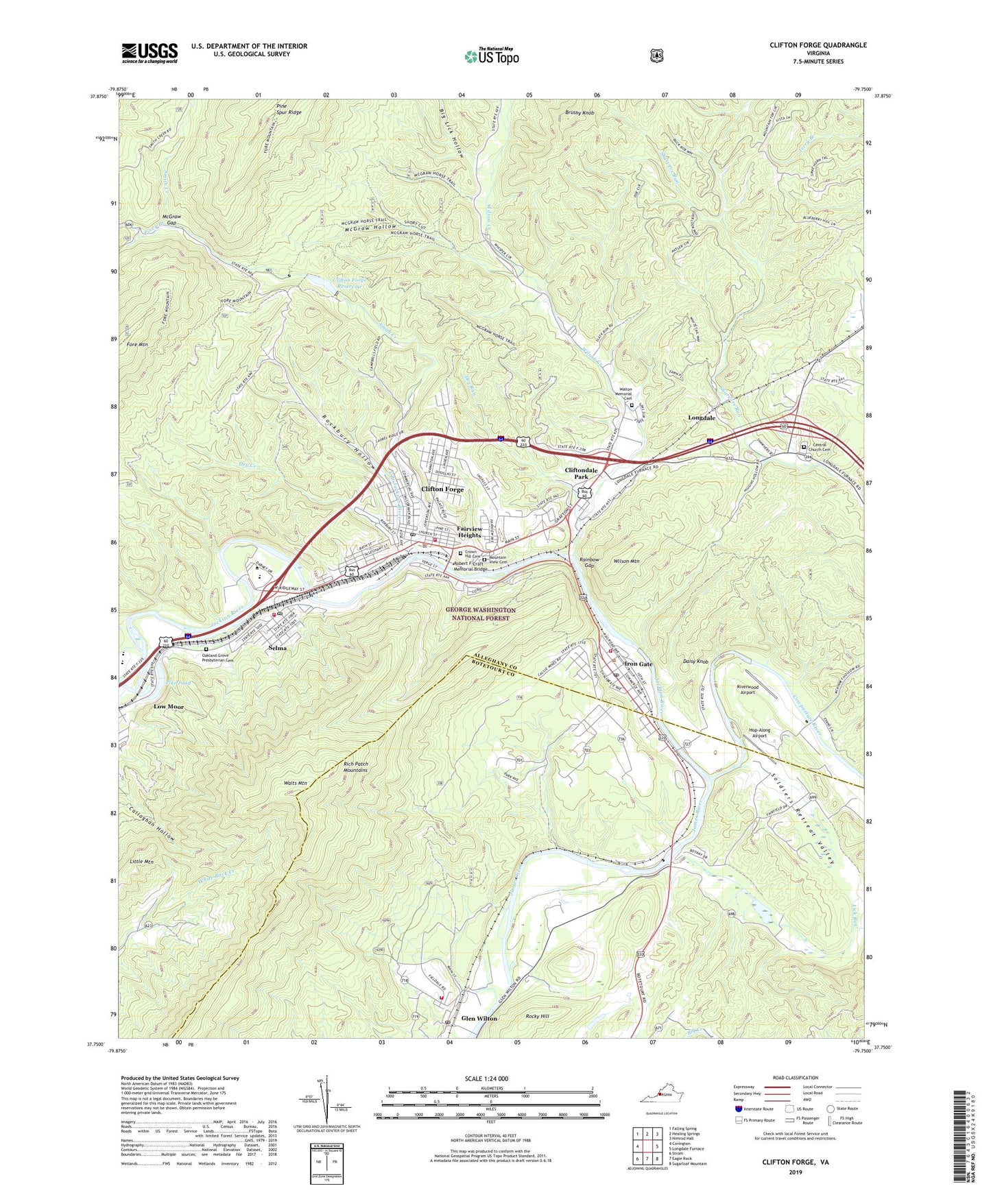
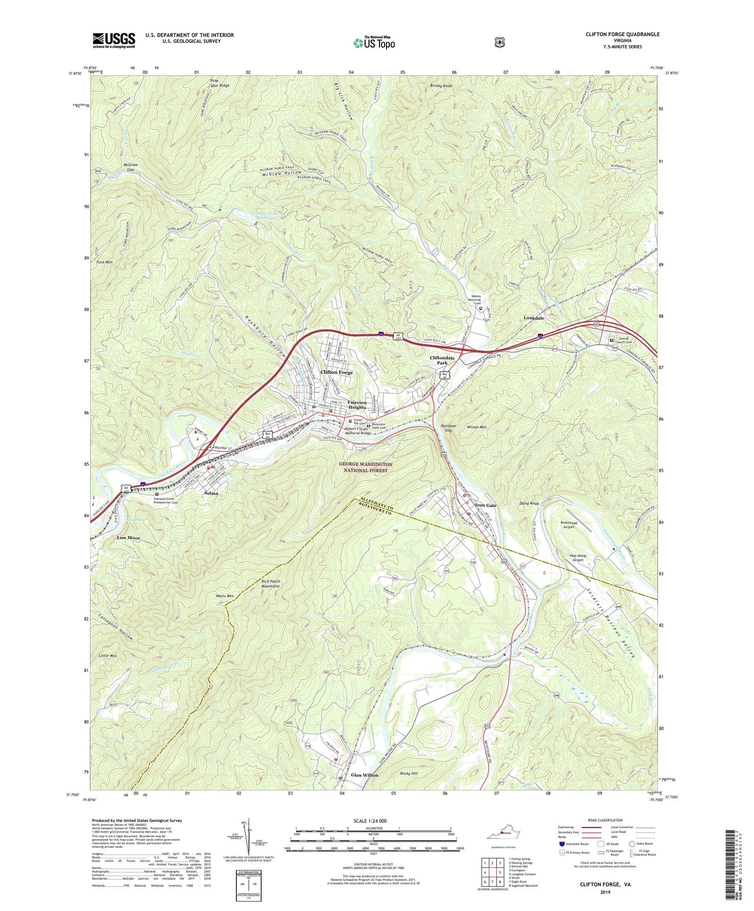
2019 topographic map quadrangle Clifton Forge in the state of Virginia. Scale: 1:24000. Based on the newly updated USGS 7.5' US Topo map series, this map is in the following counties: Alleghany, Botetourt. The map contains contour data, water features, and other items you are used to seeing on USGS maps, but also has updated roads and other features. This is the next generation of topographic maps. Printed on high-quality waterproof paper with UV fade-resistant inks.
Quads adjacent to this one:
West: Covington
Northwest: Falling Spring
North: Healing Springs
Northeast: Nimrod Hall
East: Longdale Furnace
Southeast: Sugarloaf Mountain
South: Eagle Rock
Southwest: Strom
Contains the following named places: Assembly of God Church, Big Lick Hollow, Booker T Washington Park, Brushy Knob, C and O Hospital, Callie Furnace, Central Advent Christian Church Cemetery, Central Church, Central United Methodist Church, Church of the Brethren, Clifton Forge, Clifton Forge Baptist Church, Clifton Forge City Hall, Clifton Forge East District, Clifton Forge Elementary School, Clifton Forge Fire Department, Clifton Forge High School, Clifton Forge Industrial Park, Clifton Forge Lower Dam, Clifton Forge Police Department, Clifton Forge Post Office, Clifton Forge Presbyterian Church, Clifton Forge Public Library, Clifton Forge Reservoir, Clifton Forge Volunteer Rescue Squad, Clifton Forge West District, Clifton Middle School, Cliftondale Park, Cliftondale Park Census Designated Place, Cowpasture River, Crown Hill Cemetery, Daisy Knob, Dry Creek, Dry Run, Eagle Rock Volunteer Rescue Squad Glen Wilton Station, East Branch Jackson River, Epworth United Methodist Church, Fairview Heights, First Baptist Church, First Christian Church, Glen Wilton, Glen Wilton Census Designated Place, Glen Wilton Post Office, Glen Wilton Volunteer Fire and Rescue Company 6, Holy Cross Church, Hop-Along Airport, Ingleside Park, Iron Gate, Iron Gate Police Department, Iron Gate Post Office, Iron Gate Volunteer Fire Department and First Responders, Jackson River, Jackson River Governor's School, Jefferson Elementary School, Lick Run, Linden Park, Little Mountain, Locust Bottom Church, Longdale, Low Moor Census Designated Place, Main Street Baptist Church, McGraw Gap, McGraw Hollow, Memorial Park, Moody School, Mount Beulah Church, Mountain View Cemetery, Mountain View Elementary School, Oak Hill Shopping Center, Oakland Church, Oakland Grove Presbyterian Cemetery, Pike Pond, Pine Spur Ridge, Piney Branch, Rainbow Gap, Rainbow Rocks, Riverwood Airport, Robert F Craft Memorial Bridge, Rockbury Hollow, Rocky Hill, Saint Andrews Episcopal Church, Saint Josephs Roman Catholic Church, Selma, Selma Census Designated Place, Selma Post Office, Selma Public School, Selma Volunteer Fire Department and First Responders, Smith Creek, Soldiers Retreat Valley, Town of Clifton Forge, Town of Iron Gate, Triangle Hill Church, Waits Mountain, Walton Memorial Cemetery, Walton Memorial Church, WCFV Radio Tower, Wilson Creek, Wilson Mountain, WXCF-AM (Clifton Forge), WXCF-FM (Clifton Forge), ZIP Codes: 24422, 24448, 24474