MyTopo
Studley Virginia US Topo Map
Couldn't load pickup availability
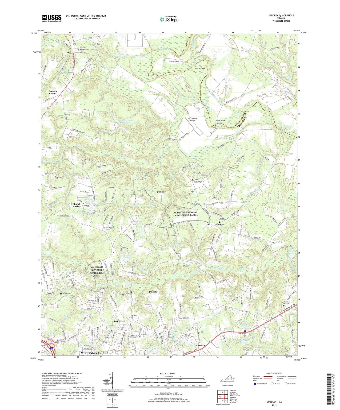
2019 topographic map quadrangle Studley in the state of Virginia. Scale: 1:24000. Based on the newly updated USGS 7.5' US Topo map series, this map is in the following counties: Hanover, King William. The map contains contour data, water features, and other items you are used to seeing on USGS maps, but also has updated roads and other features. This is the next generation of topographic maps. Printed on high-quality waterproof paper with UV fade-resistant inks.
Quads adjacent to this one:
West: Yellow Tavern
Northwest: Ashland
North: Hanover
Northeast: Beulahville
East: Manquin
Southeast: Quinton
South: Seven Pines
Southwest: Richmond
Contains the following named places: Abraham Cemetery, Academy, Academy Creek, Avondale, Battlefield Green, Battlefield Park Elementary School, Battlefield Park Elementary School Annex, Bell Creek North, Benthill, Buckeye, Cady, Cady Creek, Cady Lake, Campbell Creek, Cherrydale, Cherrydale West, Chestnut Grove Baptist Church Cemetery, Chestnut Grove Church, Colonial Forest, Colonial Forest Dam, Colonial Forest Lake, Crosses Corner, Crossroads Christian School, Crump Creek, Crump Neck, Eastern Hanover Volunteer Fire Department Meeting Building, Enon Cemetery, Enon Church, Fieldshire, Fire Station Number1, First Union Church, Georgetown, Gethsemane Cemetery, Gethsemane Church, Greenway, Guilds Acres, Hanover County Fire - EMS Company 3 - Eastern Hanover Volunteer Fire Station, Hawes Millrace, Heatherwood, Henry District, Hilly Farms, Hughes Corner, Hundleys Corner, James City Rescue Squad, Kersey Creek, Linney Corners, Locust Green, Mantilo Branch, Mattawan, Mattawan Association Dam, Meadow Gate, Mechanicsville Census Designated Place, Millpond Creek, Nanover Learning Center Dam, Nazarene Church, Nelson Bridge, Nelson Ferry, New Bethesda Church, New Bethesda Church Cemetery, New Chestnut Grove Church, Newman, Oak Forest, Opossum Creek, Orchard Gardens, Pamunkey Estates, Pebblebrook, Pebblebrook Dam, Pebblebrook Lake, Pine Hill, Pine Ridge Farms, Pole Green, Pole Green Church, Pole Green Elementary School, Pollard Creek, Pong Swamp, Rainer Dam, Rainier Estates, Raven Run, Robertson Airport, Robin Ridge, Rural Point, Rural Point Elementary School, Salem Church, School Number 5, Second Union Cemetery, Second Union Church, Shady Grove Church, Shady Grove School, Shannondale Estates, Signal Hill Memorial Park, State Industrial School, Strawhorn, Strawhorn Creek, Studley, Studley Farms, Studley Post Office, Sullens Creek, Sutton Neck, Swannanoa Estates, Talley Millpond, Talleys Dam, The Colonies, Timberlake Dam Number One, Timberlake Dam Number Two, Timberlake Pond Number One, Timberlake Pond Number Two, Virginia Department of Correctional Education - Barrett Juvenile Correctional Center, Woods Farm Airstrip, WZXK-TV (Ashland), Zion Cemetery, ZIP Code: 23116