MyTopo
Fort Lewis Washington US Topo Map
Couldn't load pickup availability
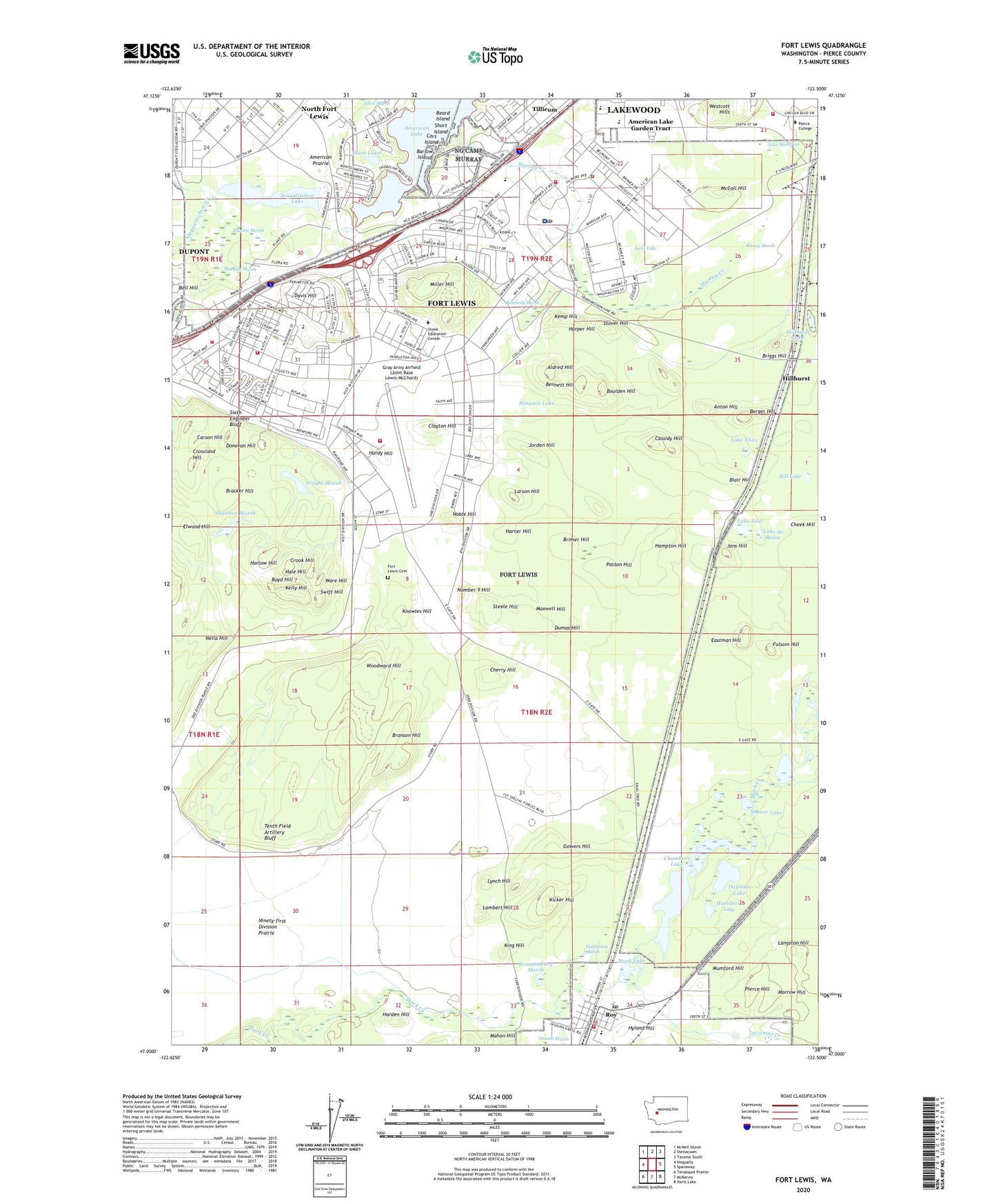
2020 topographic map quadrangle Fort Lewis in the state of Washington. Scale: 1:24000. Based on the newly updated USGS 7.5' US Topo map series, this map is in the following counties: Pierce. The map contains contour data, water features, and other items you are used to seeing on USGS maps, but also has updated roads and other features. This is the next generation of topographic maps. Printed on high-quality waterproof paper with UV fade-resistant inks.
Quads adjacent to this one:
West: Nisqually
Northwest: McNeil Island
North: Steilacoom
Northeast: Tacoma South
East: Spanaway
Southeast: Harts Lake
South: McKenna
Southwest: Tenalquot Prairie
Contains the following named places: Aldred Hill, Alpine Estates Mobile Home Park, American Lake Garden Tract, American Prairie, Anderson Woods, Anton Hill, Barlow Island, Beachwood Child Development Center, Beachwood Elementary School, Beard Island, Bell Hill, Bell Woods, Bennett Hill, Berger Hill, Bill Lake, Blair Hill, Bloyd Woods, Bossi Woods, Boulden Hill, Bower Woods, Boyd Hill, Bracker Hill, Brandenburg Marsh, Branson Hill, Briggs Hill, Brimer Hill, Camp Murray, Care Bear Child Care Center, Carson Hill, Cassidy Hill, Chambers Lake, Chambers Lake Dam, Cheek Hill, Cherry Hill, Cherry Woods, Clarkmoor Child Development Center, Clarkmoor Elementary School, Clayton Hill, Cors Island, Cramer Woods, Crook Hill, Crossland Hill, Dailman Lake, Davis Hill, Davis Woods, Donovan Hill, Dumas Hill, Dupoint School, Eastman Hill, Ellsworth Woods, Elwood Hill, Evergreen Elementary School, Faith For Living Covenant Church, Folsom Hill, Fort Lewis, Fort Lewis - Mcchord Fire and Emergency Services Station 101 Headquarters, Fort Lewis - McChord Fire and Emergency Services Station 102, Fort Lewis - McChord Fire and Emergency Services Station 103, Fort Lewis - McChord Fire and Emergency Services Station 104, Fort Lewis - McChord Fire and Emergency Services Station 106, Fort Lewis - McChord Fire and Emergency Services Station 107, Fort Lewis Cemetery, Fort Lewis Census Designated Place, Fort Lewis-DuPont Division, Gorden Woods, Gowers Hill, Gray Army Airfield (Joint Base Lewis-McChord), Greenwood Elementary School, Hale Hill, Halverson Marsh, Hamilton Lake, Hampton Hill, Hanner Marsh, Harden Hill, Hardy Hill, Harlow Hill, Harper Hill, Harter Hill, Hillhurst, Hillhurst Lake, Hillside, Hillside Elementary School, Holden Woods, Hyland Hill, Jamestown Estates Mobile Home Park, Jans Hill, Johnson Marsh Dam, Jorden Hill, Kelly Hill, Kemp Hill, Kennedy Marsh, Kennedy Woods, Kicker Hill, King Hill, Kinsey Marsh, Knowles Hill, Lacamas Creek, Lake de Balon, Lake Elias, Lake Mondress, Lake Saul, Lambert Hill, Langston Hill, Larson Hill, Long Woods, Lynch Hill, Lynn Lake, MacKay Marsh, Madigan Ambulance Service at Madigan Army Medical Center, Madigan Army Medical Center, Madigan Hospital Heliport, Madigan Hospital Post Office, Mahon Hill, Marne Forest, Maxwell Hill, McCall Hill, McCall Woods, Miller Hill, Miller Woods, Moonshine Woods, Morrow Hill, Muck, Muck Lake, Mumford Hill, Murray Creek, Nella Hill, Ninety-first Division Prairie, Noble Hill, North Fort Lewis Census Designated Place, North Fort Youth Center, Number 9 Hill, Patton Hill, Pierce Hill, Roy, Roy Elementary School, Roy Post Office, Sears Lake, Sequalitchew Lake, Shannon Marsh, Shaver Lake, Short Island, Simpson Lake, Sixth Engineer Bluff, South Pierce Fire and Rescue Station 17, Steele Hill, Stover Hill, Swift Hill, Tenth Field Artillery Bluff, Tillicum, US Army Fire Department Fort Lewis, Ware Hill, Westcott Hills, Wilgar Woods, Woodbrook Middle School, Woodbrook Mobile Home Park, Woodward Hill, Wright Marsh, ZIP Codes: 98430, 98433