MyTopo
Apple Grove West Virginia US Topo Map
Couldn't load pickup availability
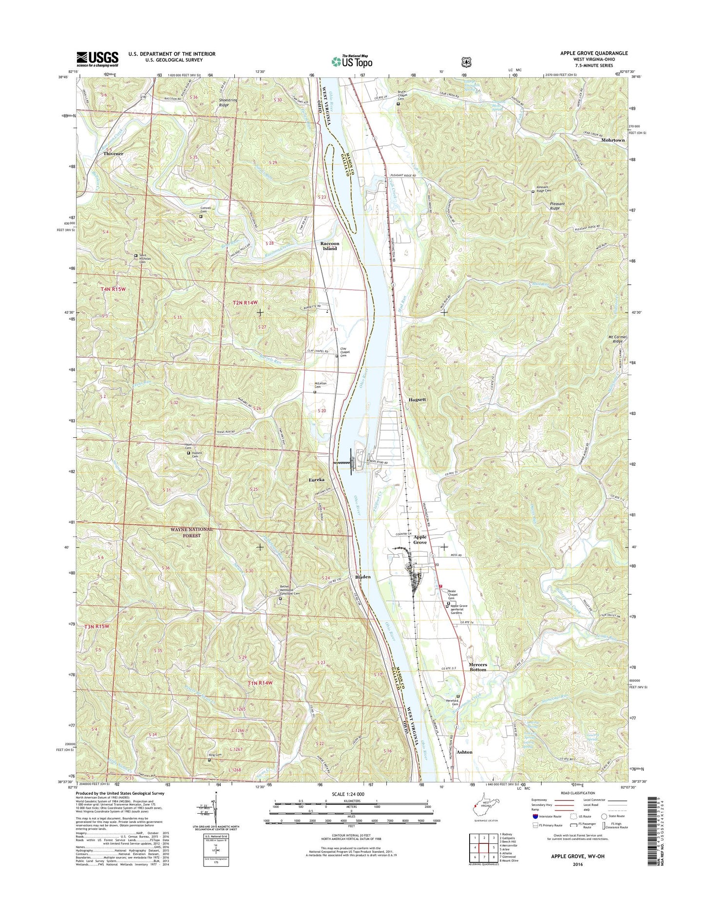
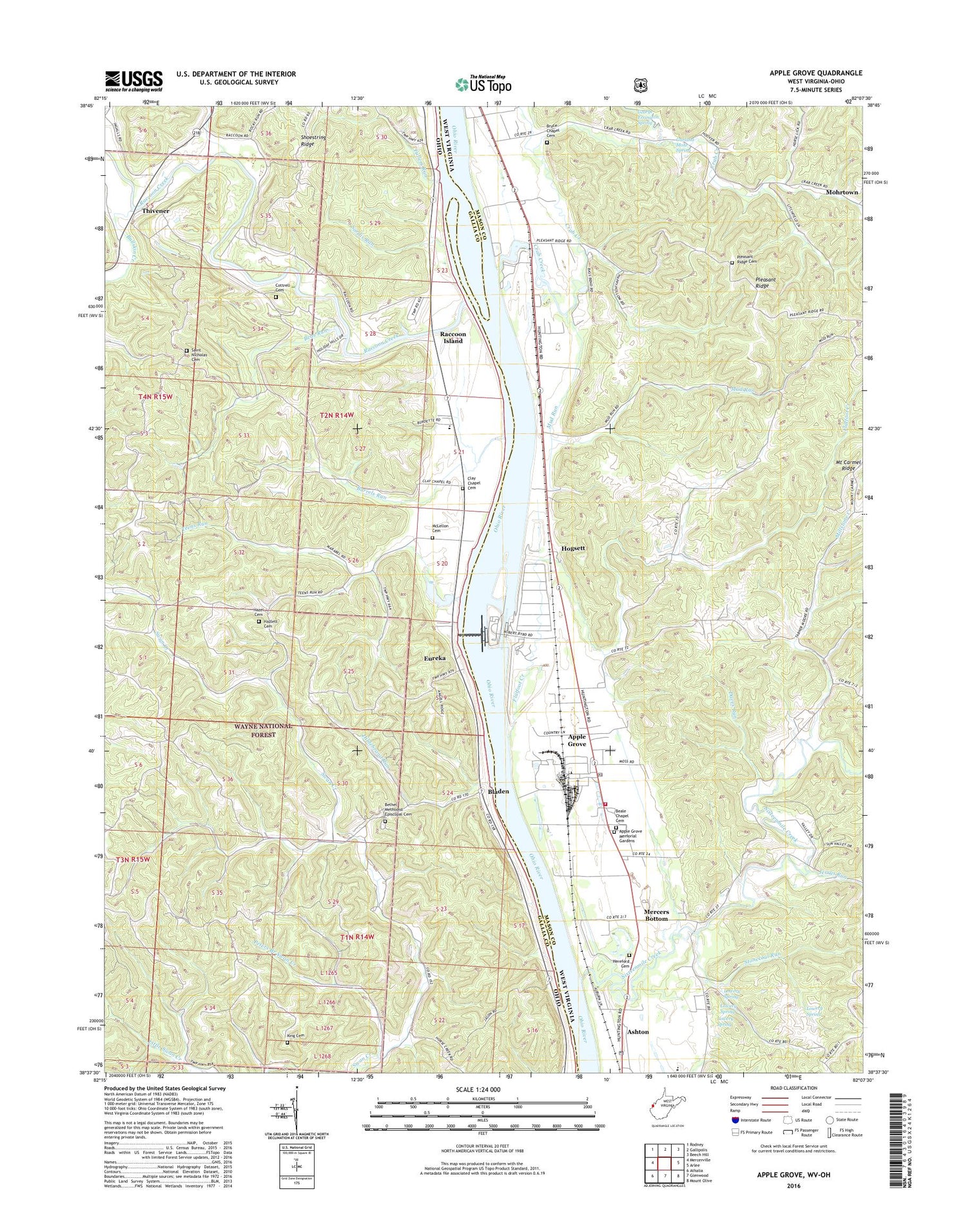
2019 topographic map quadrangle Apple Grove in the states of Ohio, West Virginia. Scale: 1:24000. Based on the newly updated USGS 7.5' US Topo map series, this map is in the following counties: Mason, Gallia. The map contains contour data, water features, and other items you are used to seeing on USGS maps, but also has updated roads and other features. This is the next generation of topographic maps. Printed on high-quality waterproof paper with UV fade-resistant inks.
Quads adjacent to this one:
West: Mercerville
Northwest: Rodney
North: Gallipolis
Northeast: Beech Hill
East: Arlee
Southeast: Mount Olive
South: Glenwood
Southwest: Athalia
Contains the following named places: Angola, Angola Post Office, Apple Grove, Apple Grove Census Designated Place, Apple Grove Memorial Gardens, Apple Grove Post Office, Ashton Elementary School, Ashton Post Office, Barkers Landing, Beale Chapel, Beale Chapel Cemetery, Bear Run, Ben Lomond, Bethel Methodist Episcopal Cemetery, Bethel School, Bladen, Bladen Post Office, Bruce Chapel, Bruce Chapel Cemetery, Bullskin Creek, Burrels Run, Bushs Mill, Campbells Landing, Clay Chapel Cemetery, Clay Chapel Methodist Church, Clay Elementary School, Clemma, Clemma Post Office, Coles Landing, Cottrell Cemetery, Crab Creek, Daves Run, Edna Chapel, Elizabeth Chapel, Eureka, Eureka Church of Christ, Eureka Church of God, Eureka Post Office, Flatfoot Creek, Fullers Run, Gallipolis Lock and Dam, Garland Mohr Spring, George Errington Spring, Halley, Halley Post Office, Hazel Cemetery, Hazlett Cemetery, Hereford Cemetery, Hildebrand Run, Hogsett, Holiday Hills, Jerrys Run, King Cemetery, Kings Chapel, Liberty Chapel, Lock and Dam Number 26, Lowery Spring, Mason County Emergency Ambulance Service Authority 200, McLellon Cemetery, Mercers Bottom, Middle Fork Crab Creek, Millstone Church, Millstone Creek, Mohrtown, Mud Run, Mud Run Church, Nicholas Church, Outons Landing, Peters Branch Swan Creek, Pleasant Ridge, Pleasant Ridge Cemetery, Pleasant Ridge Church, Raccoon Creek, Raccoon Island, Riggs Landing, Saint Nicholas Cemetery, Sand Fork Crab Creek, Sardis Run, Shoestring Ridge, Sixteenmile Creek, Smalls Landing, Stonecoal Run, Sunnyside School, Teens Run, Thivener, Thivener Post Office, Township of Clay, Township of Ohio, Valley Volunteer Fire Department