MyTopo
Cedar Grove West Virginia US Topo Map
Couldn't load pickup availability
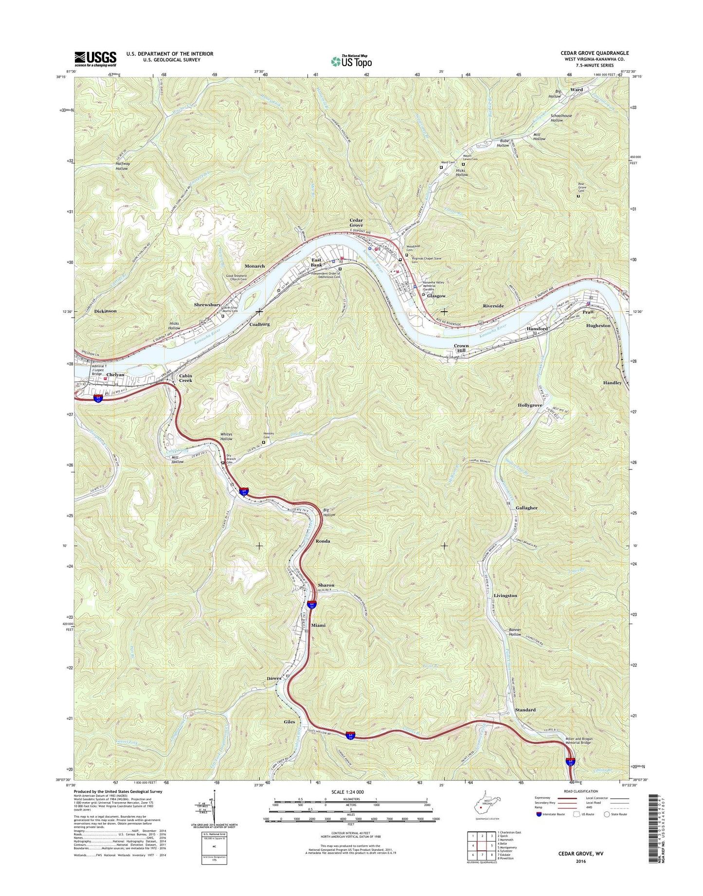
2019 topographic map quadrangle Cedar Grove in the state of West Virginia. Scale: 1:24000. Based on the newly updated USGS 7.5' US Topo map series, this map is in the following counties: Kanawha. The map contains contour data, water features, and other items you are used to seeing on USGS maps, but also has updated roads and other features. This is the next generation of topographic maps. Printed on high-quality waterproof paper with UV fade-resistant inks.
Quads adjacent to this one:
West: Belle
Northwest: Charleston East
North: Quick
Northeast: Mammoth
East: Montgomery
Southeast: Powellton
South: Eskdale
Southwest: Sylvester
Contains the following named places: Admiral T J Lopez Bridge, Banner Hollow, Bedford, Beulah Church, Big Hollow, Bufflick Branch, Cabin Creek, Cabin Creek Post Office, Calvert Field, Cedar Grove, Cedar Grove Community School, Cedar Grove Elementary School, Cedar Grove Middle School, Cedar Grove Police Department, Cedar Grove Post Office, Cedar Grove Volunteer Fire Department, Chelyan, Chelyan Census Designated Place, Chelyan Elementary School, Chelyan Methodist Episcopal Church, Chelyan Post Office, Church of Christ, Church of the Nazarene, Coalburg, Collins Branch, Crown Hill, Crown Hill Post Office, Dawes, Dawes Post Office, District 1, Dry Branch, Dry Branch Cemetery, Dry Branch Post Office, East Bank, East Bank High School, East Bank Middle School, East Bank Police Department, East Bank Post Office, East Bank Volunteer Fire Department, East Bank Volunteer Fire Department Chelyan Substation, First Baptist Church, Fourmile Fork, Frozen Branch, Gallagher, Gallagher Post Office, Giles, Glasgow, Glasgow Police Department, Glasgow Public Library, Glasgow Volunteer Fire Department, Good Shepherd Church, Good Shepherd Church Cemetery, Greens Branch, Halfway Hollow, Hampton Church, Haney Fork, Hansford, Hansford Census Designated Place, Hansford Post Office, Hensley Cemetery, Hicks Hollow, Hollygrove, Hollygrove Census Designated Place, Horsemill Branch, Independent Order of Oddfellows Cemetery, John Hansford School, Jones Branch, Kanawha County Emergency Ambulance Authority, Kanawha County Emergency Ambulance Authority Station 12, Kanawha County Emergency Ambulance Authority Station 68, Kanawha County Sheriffs Office - Chelyan Detachment, Kanawha Valley Memorial Gardens, Kellys Creek, Lacie - Gray - Morris Cemetery, Laurel Fork, Left Fork Longbottom Creek, Left Fork Witcher Creek, Little Brick Church, Livingston, Longbottom Creek, Miami, Miami Post Office, Milburn Branch, Mile Branch, Mill Hollow, Miller and Brogan Memorial Bridge, Monarch, Mount Lewis Cemetery, Mount Zion Church, Paint Branch, Paint Creek, Pine Grove Cemetery, Pratt, Pratt Community Volunteer Fire Department, Pratt Elementary School, Pratt Historic District, Pratt Police Department, Pratt Post Office, Riverside, Ronda, Rube Hollow, Schoolhouse Hollow, Sharon, Sharon Dawes Elementary School, Sharon Post Office, Sharon-Dawes Consolidated School, Shrewsbury, Shrewsbury Census Designated Place, Shrewsbury Post Office, Slaughter Creek, South Chelyan Primary School, Standard, Sugarcamp Branch, Town of Cedar Grove, Town of East Bank, Town of Glasgow, Town of Pratt, Upper Witcher School, Virginias Chapel Slave Cemetery, Ward, Ward Cemetery, Watson Branch, Wet Branch, Wet Branch Church, Wet Branch School, Whites Hollow, Woodland Cemetery, ZIP Codes: 25015, 25061, 25067, 25086, 25103, 25134, 25162