MyTopo
Delbarton West Virginia US Topo Map
Couldn't load pickup availability
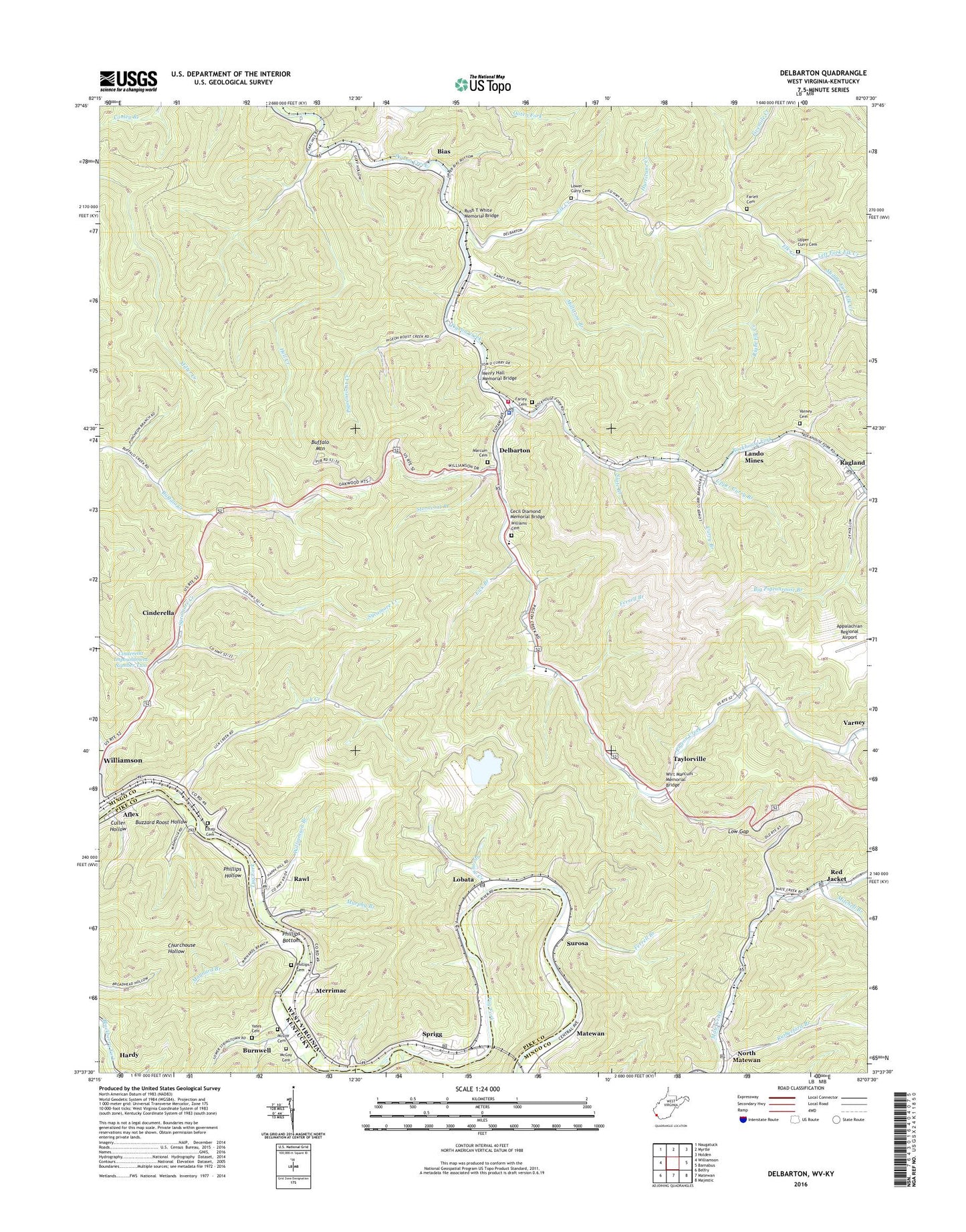
2019 topographic map quadrangle Delbarton in the states of West Virginia, Kentucky. Scale: 1:24000. Based on the newly updated USGS 7.5' US Topo map series, this map is in the following counties: Mingo, Pike. The map contains contour data, water features, and other items you are used to seeing on USGS maps, but also has updated roads and other features. This is the next generation of topographic maps. Printed on high-quality waterproof paper with UV fade-resistant inks.
Quads adjacent to this one:
West: Williamson
Northwest: Naugatuck
North: Myrtle
Northeast: Holden
East: Barnabus
South: Matewan
Southwest: Belfry
Contains the following named places: Aflex, Aflex Post Office, Aflex School, Bias, Buffalo Mountain, Buffalo Mountain Lookout Tower, Buffalo School, Burch, Burch Elementary School, Burch High School, Burnwell, Burnwell Post Office, Buzzard Roost Hollow, Cecil Diamond Memorial Bridge, Church of God, Cinderella, Cinderella Coal Waste Embankment Dam, Cinderella Impoundment Number Two, Connolly Memorial Baptist Church, Culler Hollow, Curry Branch, Delbarton, Delbarton Police Department, Delbarton Post Office, Delbarton United Baptist Church, Delbarton Volunteer Fire Department Station 1, Elk Creek, Elk Creek Church, Elk Creek Community Church, Elk School, Estep Cemetery, Farley Cemetery, Ferrell Branch, Fivemile Creek, Forest School, Hell Creek, Henry Hall Memorial Bridge, Hurricane Creek, Lando Mines, Lee District, Left Fork Elk Creek, Lick Branch, Lick Creek, Lobata, Lobata Post Office, Low Gap, Lower Curry Cemetery, Lower Stringtown Branch, Marcum Cemetery, Matewan High School, Matewan Middle School, Maynard Branch, McCoy Cemetery, Merrimac, Middle Fork Elk Creek, Millstone Branch, Mingo Career and Technical Center, Mingo County, Mitchell Branch, Murphy Branch, North Matewan, North Matewan Post Office, Omega Bible Academy, Phillips Bottom, Phillips Cemetery, Phillips Hollow, Pigeonroost Creek, Puritan Mines, Ragland, Ragland Post Office, Rawl, Rawl Post Office, Red Jacket, Red Jacket Census Designated Place, Red Jacket Elementary School, Red Jacket Post Office, Regional Christian School, Right Elk Creek, Rockhouse Fork, Round Bottom Branch, Rush T White Memorial Bridge, Rutherford Branch, Slate Branch, South Branch Rockhouse Fork, Sprigg, Sprigg Post Office, Sprouse Creek, Stat Ambulance Service Incorporated, Stonecoal Branch, Stringtown, Stringtown School, Surosa, Sycamore Creek, Taylorville, Taylorville Census Designated Place, Town of Delbarton, Tug River District, Tug Valley Country Club Golf Course, Upper Curry Branch, Upper Curry Cemetery, Upper Stringtown Branch, Varney Cemetery, Varney School, Wallace Hatfield School, Williams Cemetery, Williamson Branch, Wirt Marcum Memorial Bridge, WVKM-FM (Matewan), Yates Cemetery, ZIP Code: 25670