MyTopo
Matewan West Virginia US Topo Map
Couldn't load pickup availability
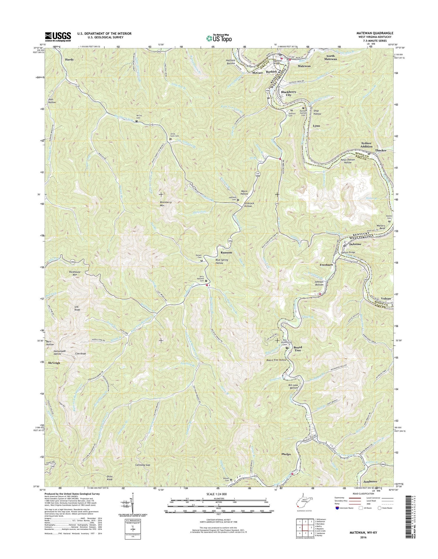
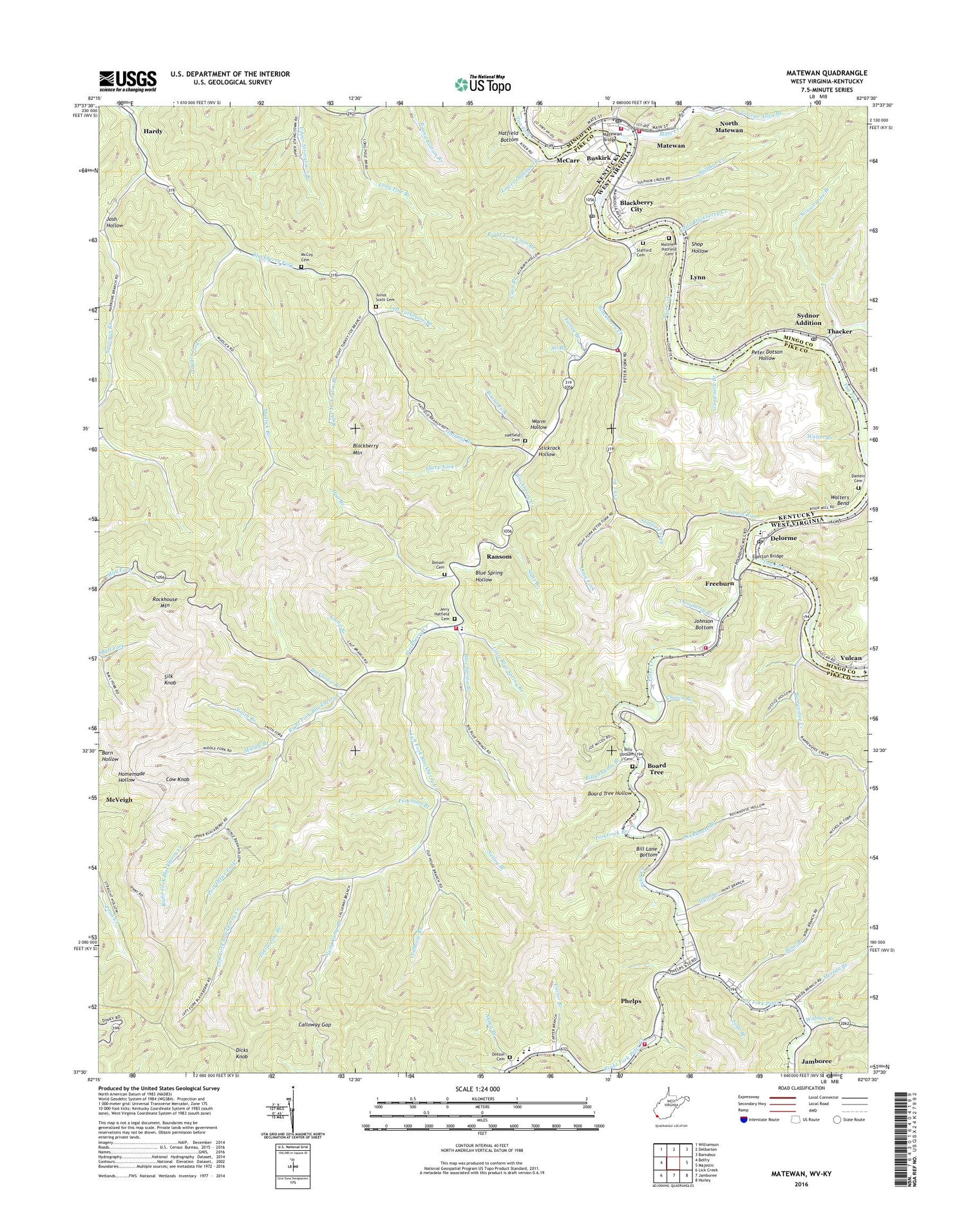
2019 topographic map quadrangle Matewan in the states of Kentucky, West Virginia. Scale: 1:24000. Based on the newly updated USGS 7.5' US Topo map series, this map is in the following counties: Mingo, Pike. The map contains contour data, water features, and other items you are used to seeing on USGS maps, but also has updated roads and other features. This is the next generation of topographic maps. Printed on high-quality waterproof paper with UV fade-resistant inks.
Quads adjacent to this one:
West: Belfry
Northwest: Williamson
North: Delbarton
Northeast: Barnabus
Southeast: Hurley
South: Jamboree
Southwest: Lick Creek
Contains the following named places: Abbey Branch, Ail Branch, Arrow, Barrenshee Creek, Big Root Branch, Big Stream Branch, Bill Lane Bottom, Billy Dotson Branch, Billy Dotson Cemetery, Blackberry Church, Blackberry City, Blackberry Creek, Blackberry Fire Department Station 2, Blackberry Fork Park, Blackberry Mountain, Blackberry Post Office, Blackberry School, Blackberry Volunteer Fire Department, Blue Spring Branch, Blue Spring Church, Blue Spring Hollow, Board Fork, Board Tree, Board Tree Hollow, Bone Branch, Bull Branch, Buskirk, Calloway Gap, Camp Branch, Carter Branch, Christ Temple Church, Church Branch, Columbiatown, Coon Branch, Cow Knob, Daniels Cemetery, Daugherty Branch, Delorme, Dial Branch, Dick Post Office, Dicks Knob, Dotson Cemetery, Edgarton Post Office, Edgerton Post Office, Egerton Bridge, Faith Church, Farley Branch, Freeborn Church, Freeburn, Freeburn Census Designated Place, Freeburn Post Office, George Allen Branch, Gooseneck Branch, Hardy, Hardy Post Office, Hatfield Bottom, Hatfield Branch, Hatfield Cemetery, Hatfield Post Office, Hatfield School, Hunt Branch, Jerry Hatfield Cemetery, John Dotson Branch, Johnson Bottom, Julius Scott Cemetery, Left Fork Blackberry Creek, Left Fork Dial Branch, Left Fork of Blackberry, Left Fork of Blackberry School, Left Fork Peter Creek, Left Turkeytoe Branch, Liss Post Office, Liss-Freeburn School, Little Blackberry Creek, Little Blue Spring Branch, Little Hope Church, Long Fork, Long Pole Branch, Lower Oldhouse Branch, Lynn, Mate Creek, Matewan, Matewan Bridge, Matewan PK - 8 School, Matewan Police Department, Matewan Post Office, Matewan Volunteer Fire Department, Matewan Volunteer Fire Department Substation, Matthew Hatfield Cemetery, Mauchlinville Branch, McCarr, McCarr Census Designated Place, McCarr Division, McCarr Post Office, McCoy Cemetery, McCoy School, Meathouse, Mereda Branch, Middle Branch, Mudlick Branch, Mudlick School, Murphy Fork, Nampa, Narrows Branch, Narrows Branch Regular Baptist Church, Narrows Branch School, Netley Branch, New Alma Church, New Alma Coal Camp, Oldhouse Branch, Pecks Branch, Peelpoplar Branch, Pete Post Office, Peter Branch, Peter Creek, Peter Dotson Hollow, Peter Post Office, Phelps, Phelps Census Designated Place, Phelps High School, Phelps Post Office, Phelps Volunteer Fire Department, Phelps Volunteer Fire Department Station 2, Pointrock Branch, Post Office Fork, Poundmill Run, Puncheon Branch, Ransom, Ransom Post Office, Red Bud, Right Fork Blackberry Creek, Right Fork Coon Branch, Right Fork Peter Creek, Right Turkeytoe Branch, Rockhouse Branch, Rockhouse Mountain, Rose Siding, Sage Branch, Samaria Primitive Baptist Church, Scissorsville Branch, Seng Camp Branch, Sheep Fork, Shop Hollow, Silk Knob, Slate Branch, Smith Branch, Stafford Cemetery, Stafford Fork, Stagger Fork, Stat Ambulance Service, Stickrock Hollow, Sulphur Creek, Sydnor Addition, Thacker, Thacker Creek, Thacker Post Office, Town of Matewan, Turkey Foot, Vulcan, Walter Branch, Walters Bend, Warm Hollow, WHJC Radio Tower, WHJC-AM (Matewan), Widows Branch, Wolf Branch, ZIP Codes: 41528, 41531, 41544, 41558