MyTopo
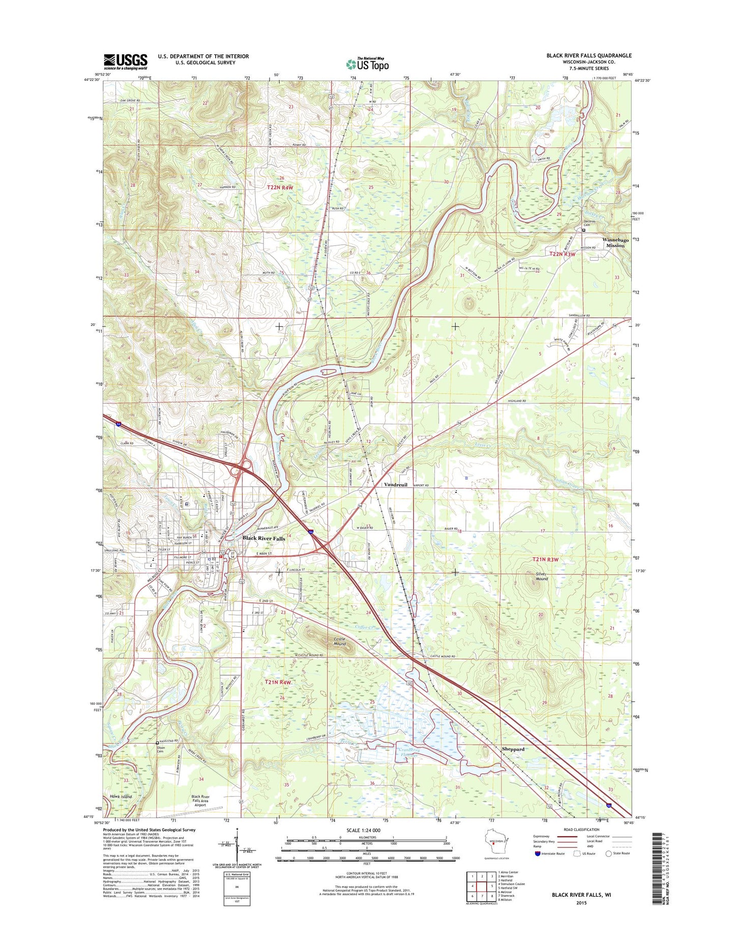
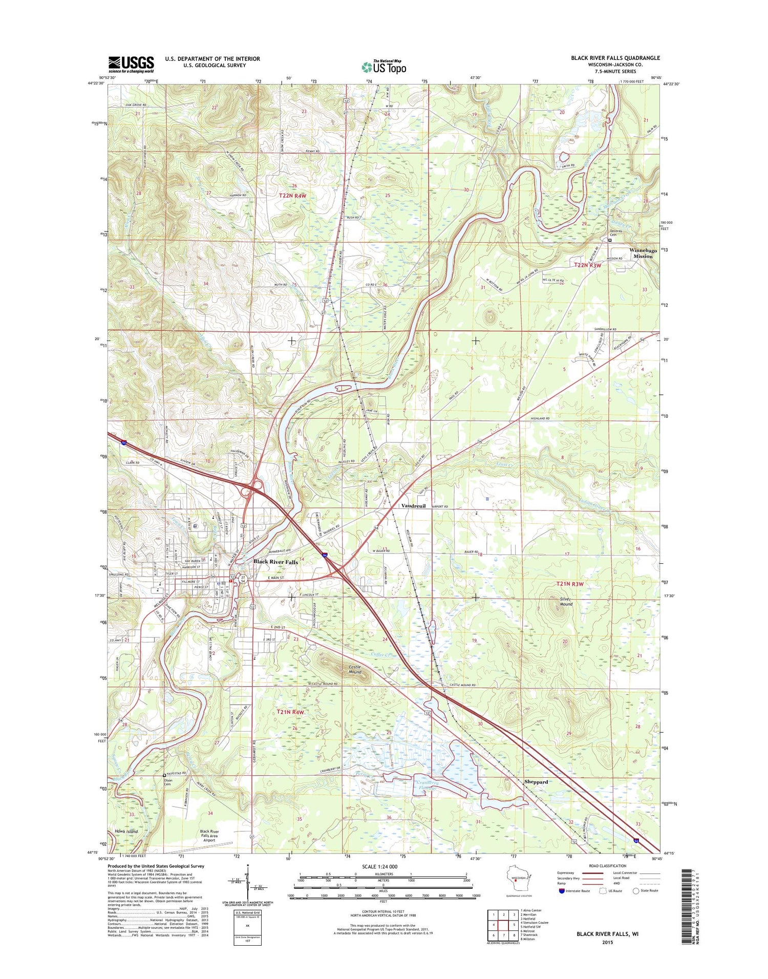
Black River Falls Wisconsin US Topo Map
Couldn't load pickup availability
2018 topographic map quadrangle Black River Falls in the state of Wisconsin. Scale: 1:24000. Based on the newly updated USGS 7.5' US Topo map series, this map is in the following counties: Jackson. The map contains contour data, water features, and other items you are used to seeing on USGS maps, but also has updated roads and other features. This is the next generation of topographic maps. Printed on high-quality waterproof paper with UV fade-resistant inks.
Quads adjacent to this one:
West: Stenulson Coulee
Northwest: Alma Center
North: Merrillan
Northeast: Hatfield
East: Hatfield SW
Southeast: Millston
South: Shamrock
Southwest: Melrose
Contains the following named places: Allen Creek, Assembly of God Church, Black River Falls, Black River Falls Area Airport, Black River Falls City Hall, Black River Falls Dam, Black River Falls Fire Department, Black River Falls Grade School, Black River Falls High School, Black River Falls Junior High School, Black River Falls Middle School, Black River Falls Police Department, Black River Falls Post Office, Black River Falls Public Library, Black River Falls Wastewater Treatment Plant, Black River Flowage 1610, Black River Memorial Hospital, Brockway, Castle Mound, Castle Mound Pine Forest State Natural Area, Castle Mound Recreation Area, Charter Oak Mills, City of Black River Falls, Clear Creek, Coffee Creek, Community Christian Church, Cranberry Flowage, Decorah Cemetery, Dickey Creek, Faith Baptist Church, First Church of Christ Scientist, First Methodist Church, Forrest Street Early Learning Center, Freeman School, Gebhardt Elementary School, Gospel Tabernacle, Halcyon School, Halls Creek, Hawk Island, Ho-Chunk Nation Community Center, Ho-Chunk Nation Tribal Office Building, Indian Grave Creek, Jackson Correctional Institution, Jackson Correctional Institution School, Jackson County, Jackson County Airport, Jackson County Courthouse, Jackson County Jail, Jackson County Sheriff's Department, Lake 31 3 7, Levis, Levis Creek, Majestic Pines Casino, Mission Census Designated Place, Morrison Creek, Ni-ho-kha-wa-ne-ey-ja, Norwegian Evangelical Lutheran Church, Perry Creek, Perry Creek Dam, Perry Creek Recreation Area, Pleasant View School, Red Creek, Rock Springs Park, Saint Johns Evangelical Lutheran Church, Saint Joseph Roman Catholic Church, Sand Pillow Census Designated Place, Sheppard, Silver Mound, Snow Creek, Snow Creek School, Squaw Creek, Sullivan Cemetery, Third Street Elementary School, Town Creek, Town of Adams, Town of Brockway, Valentine Creek, Vaudreuil, Winnebago Mission, WWIS-AM (Black River Falls), ZIP Code: 54615