
MyTopo
Chippewa Falls Wisconsin US Topo Map
Couldn't load pickup availability
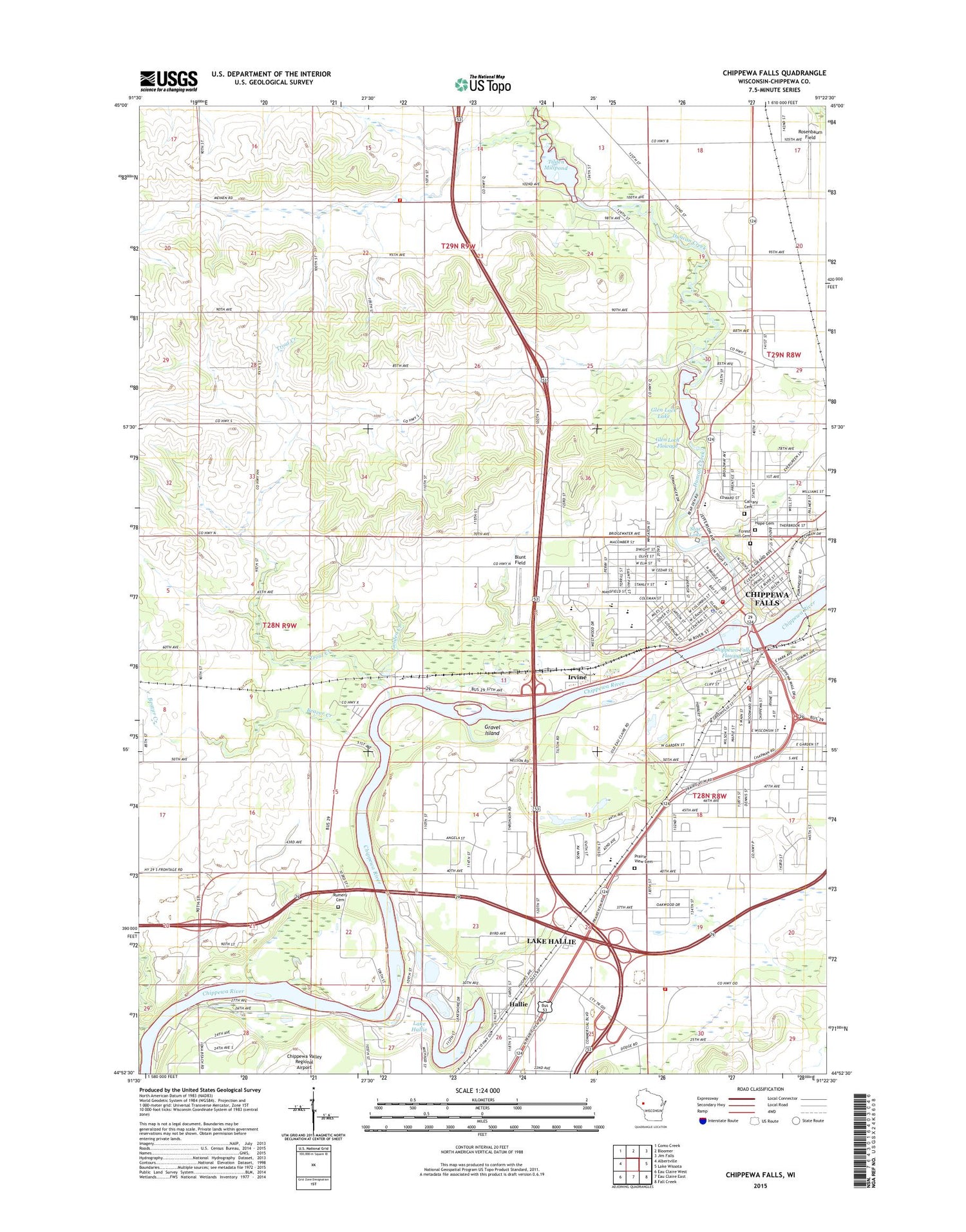
2018 topographic map quadrangle Chippewa Falls in the state of Wisconsin. Scale: 1:24000. Based on the newly updated USGS 7.5' US Topo map series, this map is in the following counties: Chippewa. The map contains contour data, water features, and other items you are used to seeing on USGS maps, but also has updated roads and other features. This is the next generation of topographic maps. Printed on high-quality waterproof paper with UV fade-resistant inks.
Quads adjacent to this one:
West: Albertville
Northwest: Como Creek
North: Bloomer
Northeast: Jim Falls
East: Lake Wissota
Southeast: Fall Creek
South: Eau Claire East
Southwest: Eau Claire West
Contains the following named places: B and S Farm, Beaudette Farms, Beaver Creek, Blunt Field, Calvary Cemetery, Camp Lawrence, Central Lutheran Church, Chippewa County Courthouse, Chippewa County Jail, Chippewa County Sheriff's Office, Chippewa Falls, Chippewa Falls City Hall, Chippewa Falls Fire and Emergency Services Station 1, Chippewa Falls Fire and Emergency Services Station 2, Chippewa Falls Flowage 5555, Chippewa Falls High School, Chippewa Falls Hydro Generating Station, Chippewa Falls Middle School, Chippewa Falls Police Department, Chippewa Falls Post Office, Chippewa Falls Public Library, Chippewa Falls Wastewater Treatment Plant, Chippewa Falls WP304 Dam, Chippewa Fire District Station 1, Christ Church, Christ Episcopal Church, Christian Gospel Chapel, City of Chippewa Falls, Cook Rutledge Historical Mansion, Crandle School, Duncan Creek, Faith Lutheran Church, First Assembly of God Church, First Presbyterian Church, First Ward School, Forest Hill Cemetery, Glen Loch 2WP1095 Dam, Glen Loch Flowage 116.5, Glen Lock Lake, Golden Creek, Gravel Island, Hallie, Hallie Church, Hallie Golf Course, Halmstad Elementary School, Hannah M Rutledge Home for the Aged, Hillcrest Elementary School, Holy Ghost Elementary School, Holy Ghost Roman Catholic Church, Hope Cemetery, Irvine, Irvine Park, Korger Chestnut Elementary School, Lake Hallie, Lake Hallie 2, Lake Hallie 2WP502 Dam, Lake Hallie Church, Lake Hallie Police Department, McDonald School, McDonell Central Catholic High School, McDonell Memorial High School, Northern Wisconsin State Fairgrounds, Notre Dame Middle School, Notre Dame Roman Catholic Church, Oak Grove School, Ojibwa Golf Club, Old Badger Mills, Our Saviours Lutheran Church, Parkview Elementary School, Peck Farms, Prairie View Cemetery, Rheingens School, Rosenbaum Field, Rumery Cemetery, Saint Charles Borromeo Catholic Church, Saint Charles Borromeo Primary School, Saint Joseph Hospital, Seventh Day Adventist Church, South Side Public School, Southview Elementary School, Star Lake, Sunnyside School, Thornsan School, Tilden 2WP150 Dam, Tilden Millpond, Tilden Volunteer Fire Department, Town of Tilden, Trinity United Methodist Church, Triple T Farms, Trout Creek, Trout Creek School, Udder Wise Dairy, Village of Lake Hallie, WAYY-AM (Chippewa Falls), Whelan Farms, WOGO-AM (Hallie), Zion Lutheran Church, Zion United Methodist Church, ZIP Code: 54729


