MyTopo
Kaukauna Wisconsin US Topo Map
Couldn't load pickup availability
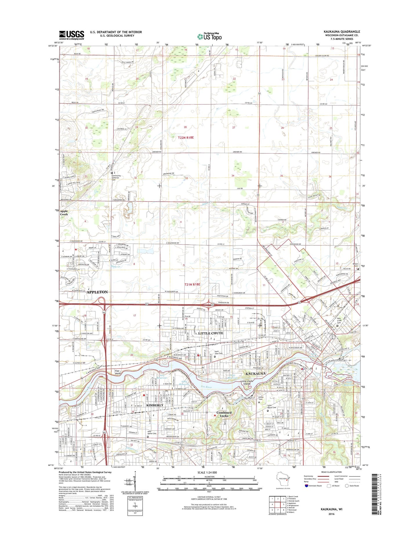
2018 topographic map quadrangle Kaukauna in the state of Wisconsin. Scale: 1:24000. Based on the newly updated USGS 7.5' US Topo map series, this map is in the following counties: Outagamie. The map contains contour data, water features, and other items you are used to seeing on USGS maps, but also has updated roads and other features. This is the next generation of topographic maps. Printed on high-quality waterproof paper with UV fade-resistant inks.
Quads adjacent to this one:
West: Appleton
Northwest: Black Creek
North: Freedom
Northeast: Oneida South
East: Wrightstown
Southeast: Hilbert
South: Sherwood
Southwest: Neenah
Contains the following named places: 6201 Reservoir, 6223 Reservoir, 6224 Reservoir, 6229 Reservoir, 6263 Reservoir, Apple Creek, Appleton Career Academy, Appleton Christian School, Appleton Fire Department Station 6, Appleton North High School, Appleton Wastewater Treatment Plant, Bethany Lutheran Church, Blaese Park, Camp Winnecomac, Caring Opportunities for Recovery Education School, Cedars Lock, Celebration Lutheran School, Central Park, City of Kaukauna, Combined Locks, Combined Locks Dam, Combined Locks Post Office, Combined Locks Volunteer Fire Department, Community Lutheran Cemetery, Doyle Park, Dr H B Tanner Elementary School, Eben School, Electa Quinney Elementary School, Elmdale School, Fernwood School, Field of Scenes, Fox Point, Fox Valley Golf Course, Fox Valley Metro Police Department, Freedom Elementary School, Freedom Quarry, Garners Creek, Grignon Park, Heesakker Park, Hermsen School, Highland School, Holy Cross Catholic Church, Holy Cross Cemetery, Holy Name Cemetery, Holy Name Roman Catholic Church, Horseshoe Park, Immanuel United Church of Christ, J R Gerritts Middle School, Janssen Elementary School, Johnston Elementary School, Kankapot Creek, Kaukauna, Kaukauna 1856c112 Dam, Kaukauna City Police Department, Kaukauna Community Hospital, Kaukauna Community Hospital Heliport, Kaukauna Fire and Rescue Department, Kaukauna High School, Kaukauna Pentecostal Church, Kaukauna Post Office, Kaukauna Public Library, Kelso Cemetery, Kimberly, Kimberly High School, Kimberly Laws1848 Dam, Kimberly Post Office, Kimberly Presbyterian Church, Kimberly Village Hall, Kimberly Volunteer Fire Department, La Follette Park, Legion Park, Lindberg Park, Little Chute, Little Chute 1856c112 Dam, Little Chute Elementary School, Little Chute High School, Little Chute Islands, Little Chute Middle / Intermediate School, Little Chute Post Office, Little Chute Volunteer Fire Department, Lower Kaukauna 2-Wp-381 Dam, Mapleview Intermediate School, Mount Calvary Evangelical Lutheran Church, Mount Calvary Lutheran School, Nicolet Elementary School, Oakwood Hills Golf Course, Outagamie County Landfill, Park Community Charter School, River View Middle School, Riverside Park, Roosevelt Park, Ryan School, Saint Aloysius Catholic Church, Saint Aloysius Elementary School, Saint Bernadette School, Saint Ignatius Catholic School, Saint John Cemetery, Saint John Nepomucene School, Saint Johns Catholic Church, Saint Luke Lutheran Church, Saint Mary Middle School, Saint Mary's Cemetery, Saint Marys Roman Catholic Church, Saint Nicholas Church, Saint Pauls Catholic Church, Saint Peter Evangelical Lutheran Church, Saint Peter Lutheran School, Schaefer Park, Speel School, Sunny Corner School, Sunset Point Park, Thousand Island State Conservancy Area, Town of Freedom, Town of Vandenbroek, Trinity Evangelical Lutheran Church, Trinity Lutheran School, Union Cemetery, Van Zeeland Park, Vandenbroek - Kaukauna Fire and Rescue, Verhagen Park, Victor Haen Elementary School, Village of Combined Locks, Village of Kimberly, Village of Little Chute, Westside Elementary School, WHBY-AM (Appleton), White City Park, ZIP Codes: 54113, 54136, 54140