MyTopo
Chelsea MyTopo Explorer Series Map
Couldn't load pickup availability
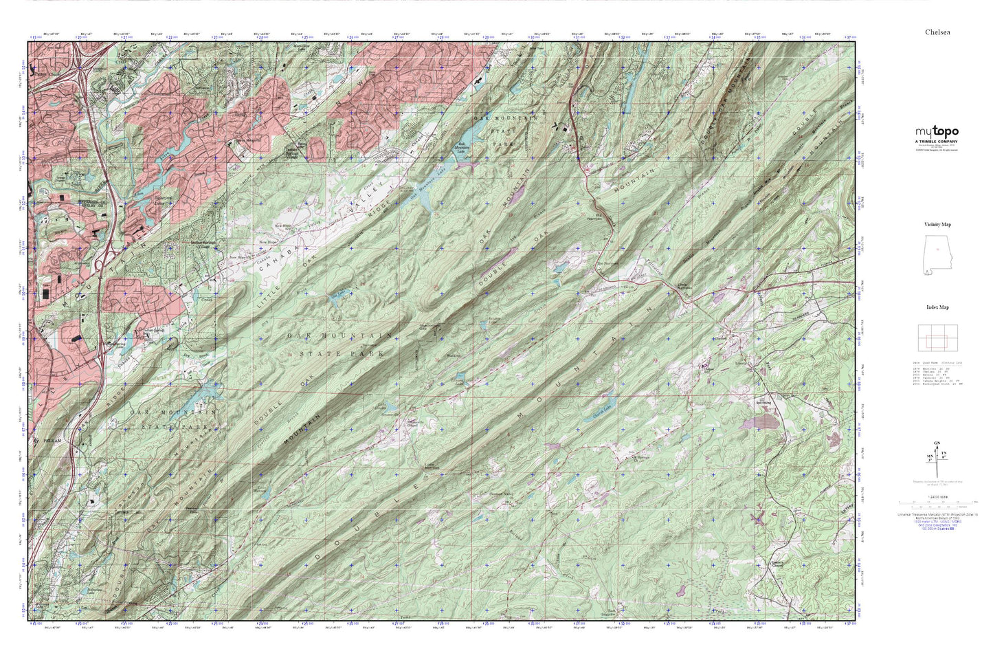
Topographic map of Chelsea in the state of Alabama. From the MyTopo Explorer Series.
This topo map features shaded relief and comes with UTM / MGRS and Latitude/Longitude grids.
For more than two decades, MyTopo has provided maps to the most adventurous among us.. those who love to explore our nation’s remote wilderness areas, climb our highest peaks, and trek across our vast public lands. This map is part of a curated collection of the most popular places for which MyTopo customers have designed maps. It is a “bucket list” of the most amazing places to hike, hunt, and explore.
This map contains the following named places: 35043,35124,Acton Creek,Acton Mine,Allan Cemetery,Allen Church,Bailey Brook,Bailey Cemetery,Bailey Gap,Belcher Lake,Belcher Lake Dam,Belcher Lumber Company Dam,Benview School,Big Narrows,Brasier Gap,Bryan Memorial Cemetery,Bryan Presbyterian Memorial Church,Cahaba Valley Fire Station 185,Caldwell Shopping Center,Catfish Lake,Cave Spring School,Charob Lake,Charob Lake Dam,Chase Lake Country Club,Chelsea,Chelsea City Hall,Chelsea Fire and Rescue Department Station 31,Chelsea Fire and Rescue Station 32,Chelsea High School,Chelsea Post Office,City of Chelsea,City of Indian Springs Village,City of Pelham,Coalville,Cobb Bridge,Cooper Branch,Double Mountain,Double Mountain Branch,Double Oak Lake,Double Oak Mountain Lake Dam,Dry Brook,Foothills Visitors Center,Fungo Hollow,Greenlee Ford,Heardmont Park,Heritage Oaks,Hickory Ridge,Highland Church,Highland Spring,Homestead,Hoover Fire Department Station 3,Hunters Glen,Indian Hills,Indian Hills Country Club,Indian Lake Estates,Indian Spring Lake,Indian Spring School,Indian Springs Ranch,Indian Springs Shopping Center,Indian Springs Village,Indian Valley,Indian Valley Lake,Ivy Branch,Jefferson County Sewage Disposal Plant,Johnson Mountain,K Springs Cemetery,K Springs Church,Lacey Branch,Lake Gizella,Lake Melaken,Lake Melaken Dam,Lake Warren,Lake Warren Dam,Lenora Lake,Liberty Baptist Church,Liberty Cemetery,Liberty Church,Lime Branch,Little Narrows,Little Oak Ridge Estates,Little Valley,Loehmann Village Shopping Center,Lunker Lake,Miller Cemetery,Moyle Mine,New Hope,New Hope Church,New Hope Mountain,New Hope School,North Shelby County Fire and Emergency Medical District Station 1,North Shelby County Fire and Emergency Medical District Station 2,Oak Mountain Baptist Church,Oak Mountain Lake,Oak Mountain Lake Dam Number One,Oak Mountain Lake Dam Number Two,Oak Mountain New Lake Dam,Oak Mountain Old Lake Dam,Oak Mountain State Park,Odess Lake Dam,Old Acton Cemetery,Old Lake,Olive Branch School,Palladian Place Shopping Center,Peavine Branch,Peavine Falls,Pelham Fire Department Station 2,Pleasant Valley Cemetery,Pleasant Valley Church,Poplar Branch,Purdy Lake,Purdy Lake Dam,Quail Run,Quinn Cemetery,Quito,Riverbrook Plaza Shopping Center,Riverchase Promenade Shopping Center,Riverchase Sports Park,Rutherford Lake Dam Number 1,Rutherford Lake Dam Number 2,Rutherford Lake Number One,Rutherford Lake Number Two,Rutherford Lakes,Shackleford Gap,Shady Grove Cemetery,Shady Grove Church,Shelby County Sheriffs Office - East Substation,Shelby County Sheriffs Office - North Station,Shelby Mart Shopping Center,Simmsville,Simmsville Chapel,Smith Mine,Southgate Village Shopping Center,Southlake,Sunnymeadows,The Narrows,The Plaza of Rivechase Shopping Center,Tulleys Real Estate Lake Dam,Valdawood,Valley Elementary School,Valley Station,Valleydale Village Shopping Center,Watkins,Windover,Wooddale,Wyatt Lake,Wyatt Lake Dam,Yellowleaf Game Preserve