MyTopo
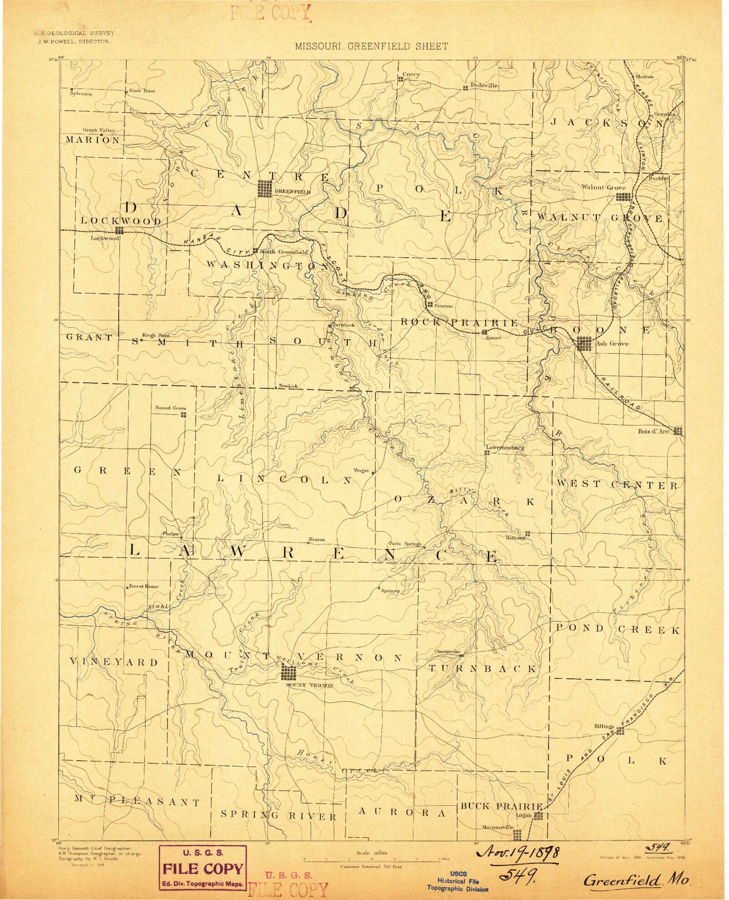
Historic 1888 Greenfield Missouri 30'x30' Topo Map
Couldn't load pickup availability
Historical USGS topographic map of Greenfield in the state of Missouri. Scale: 1:125000. Print size: 17" x 24"
This map was published in 1888 and is in the following counties: Christian, Dade, Greene, Lawrence, Polk.
The map contains contour lines, roads, rivers, towns, streams, and lakes. Printed on high-quality waterproof paper with UV fade-resistant inks.
Contains the following named places: Albatross, Ash Grove, Billies Creek, Billings, Boggy Branch, Bracket Hill, Browning Hollow, Bryant Mound, Buffalo Branch, Bunker Branch, Bunker Hill, Burney Branch, Camp Lenape, Carmen Hollow, Carson Branch, Cave Spring Branch, Chesapeake, Chesapeake Branch, Clear Creek, Colley Hollow, Corry Branch, Cuba Bluff, Daughtrey Bluff, Devils Wash Pan, Dry Branch, Dry Branch, Dry Fork, Dry Hollow, Eddington Branch, Elm Branch, Everton, Freistatt, Gentry Branch, Glass Hollow, Glass Hollow Branch, Goose Creek, Greenfield, Grider Branch, Guffy Bluff, Hall Branch, Hargrave Branch, Harold, Hawkins Branch, Hewlett Branch, Hillhouse Branch, Hoberg, Holman Branch, Honey Creek, Honey Creek, Hoyle Bluff, Itson Branch, Johnson Creek, Johnson Lake, Jordan Creek, Kelly Branch, Kings Point, Lack Branch, Limestone Creek, Logan, Lousy Branch, Lumley Branch, Marionville, Marti Hollow, Mathew Brown Branch, McKinley, Meinert, Mill Branch, Miller, Mount Vernon, Olinger, Paris Springs, Pennsboro, Phelps, Pickerel Creek, Piper Hollow, Pond Creek, Province Branch, Pruitt Branch, Ray Spring Branch, Rescue, Right of Way Branch, Round Grove, Sand Mountain, Sand Mountain, Sardine Creek, Sawdey Branch, Scott Spring Branch, Shaw Bluff, Sinking Creek, Snadon Bluff, Snadon Hollow, South Prong Sons Creek, Staley Branch, Stillhouse Hollow, Stinson, Stotts City, Stotts City, Sugar Creek, Sycamore Branch, Sycamore Creek, Sycamore Hollow, The Mound, Toney Park, Truitt Creek, Turnback Creek, Turner Hollow, Venable Spring Branch, Walnut Hollow, Ward Branch, West Fork Limestone Creek, West Prong Lynn Branch, West Prong Sons Creek, Wetzel Branch, Williams Creek, Winkle Bluff, Wright Branch, Comet, Dadeville, Lawrenceburg, Lick Prairie Community Hall, Lockwood, Lynn Branch, South Greenfield, Stahl Creek, Eudora, Walnut Grove, North Sycamore Branch, Hulston, Grays Point, East Limekiln, Roper, Yeakley, Dumbeck, Call, Doubling Spur, Skinners Spur, Landrum, Corry, Dilday Mill, Elliott, Fiddlers Ford, Hulston Mill, Knox, Nickelville, Opal, Orange, Phenix, Pilgrim, Plano, Snadon Ford, Spencer, Greenfield Public Use Area, Caseyville, Aurora Country Club, Methodist Conference Grounds, University of Missouri Experimental Farm, Bois D'Arc, Graydon Springs, Heatonville, Sims Point, Grays Valley, New Kirk, Halltown, Dade County, Lawrence County, Hedeman Farms Lake Dam, Hedeman Lake, Faucetts Point Lake Dam, Faucett Lake, Southwest Research Center Dam, Southwest Research Center Lake, Giddings Lake Dam, Dorall Lake, Spain Lake Dam, Spain Lake, Number 790 Dam, Mendenhall Lake Dam, Rector Lake Dam, Hagewood Lake Dam, Hagewood Lake, Township of Center, Township of Ernest, Township of Lockwood, Township of Pilgrim, Township of Polk, Township of Rock Prairie, Township of Smith, Township of South, Township of South Morgan, Township of Washington, Township of Boone Number 1, Township of Boone Number 2, Township of Center Number 3, Township of Pond Creek, Township of Walnut Grove, Township of Freistatt, Township of Green, Township of Hoberg, Township of Lincoln, Township of Mount Pleasant, Township of Mount Vernon, Township of Ozark, Township of Turnback, Township of Vineyard, Township of Jackson, City of Ash Grove, City of Billings, City of Everton, City of Greenfield, City of Marionville, City of Mount Vernon, City of Miller, City of Lockwood, City of Stotts City, City of Walnut Grove, Township of East Polk, Township of West Polk, Village of Halltown, Village of Hoberg, Village of Dadeville, Village of Freistatt, Village of South Greenfield, Mount Vernon Golf Course, Ozark Cavefish National Wildlife Refuge