
MyTopo
Historic 1901 Oelwein Iowa 30'x30' Topo Map
Couldn't load pickup availability
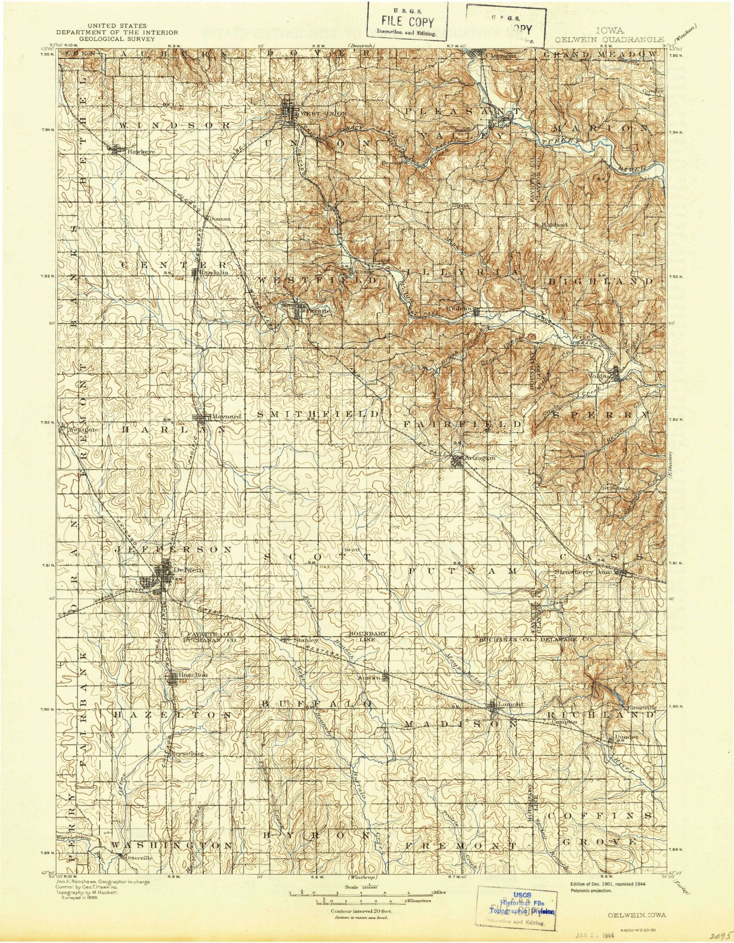
Historical USGS topographic map of Oelwein in the state of Iowa. Scale: 1:125000. Print size: 16" x 24"
This map was published in 1901 and is in the following counties: Buchanan, Clayton, Delaware, Fayette.
The map contains contour lines, roads, rivers, towns, streams, and lakes. Printed on high-quality waterproof paper with UV fade-resistant inks.
Contains the following named places: Albany, Alexander Creek, Arlington, Aurora, Backbone Lake, Backbone State Forest, Backbone State Park, Bear Creek, Bear Hill, Beaver Creek, Bell Creek, Bethel Townhall, Brainard, Bruce Creek, Brush Creek, Brush Creek Canyon State Park, Bryantsburg, Camp Ewalu, Corn Hill, Coulee Creek, Deep Creek, Deer Creek, Delwein City Park, Delwein Lake, Dibble Creek, Donnan, Dry Run, Dundee, East Branch Buffalo Creek, East Branch Pine Creek, Echo Valley State Park, Elgin, Ensign Creek, Fayette, Fenchel Creek, Fontana Lake, Fontana Park, Franklin Park, Frog Hollow, German Hollow, Glover Creek, Grannis Creek, Gunder, Hawkeye, Hazelton Creek, Hazleton, Hells Hollow, Hewett Creek, Hunter Creek, Joy Springs County Park, Klacks Island Park, Lamont, Lamont Creek, Little Volga River, Maynard, Maynard Park, Mill Race, Mink Creek, Moine Creek, Nagle Creek, North Branch Volga River, Oelwein, Otter Creek, Otter Creek Wildlife Area, Otterville, Pilot Knob, Pine Creek, Platt Park, Plum Creek, Randalia, Red Gate Park, Sand Creek, Sand Hagen Creek, Sandy Creek, South Fork Maquoketa River, Stanley, Strawberry Point, Sugar Camp Hollow, The Backbone, Twin Bridges County Park, Van Laningham County Wildlife Area, Volga, Volga River State Recreation Area, Wadena, West Branch Buffalo Creek, West Branch Pine Creek, West Prairie Church, West Union, Westgate, Wolf Creek, Wolf Hill, Lilac Plaza, Duttons Cave Campground, Scott, Forestville, Highland, Illyria, Lima, Maryville, Saint Sebald, Taylorsville, Thomasville, Fayette County, Lake Oelwein, Foursome Country Club, Hickory Grove Country Club, Campton, Buffalo Grove, Township of Buffalo, Township of Byron, Township of Cass, Township of Center, Township of Coffins Grove, Township of Fairfield, City of Fayette, Township of Fremont, Township of Harlan, Township of Hazleton, Township of Highland, Township of Illyria, Township of Jefferson, Township of Madison, Township of Marion, Township of Pleasant Valley, Township of Putnam, Township of Richland, Township of Scott, Township of Smithfield, Township of Sperry, Township of Union, Township of Washington, Township of Westfield, City of West Union, Township of Windsor, Fontana Milldam, Otterville Bridge State Access, Reedy Park, Wings Park, Levin Park, Big Rock Country Club, Volga Lake, West Union Country Club, Dutton Cave County Park, Hauth Park, Valley Canoe Access, Wildwood Nature Center, Volga River Access, Volga River Campground, Langeman's Ford, Grannis Creek Wildlife Management Area, Gilbertson Conservation Education Area, Lima Trail, Ridge Trail, Albany Trail, Lake View Trail, Frog Hollow Trail, West Union Cooperative Elevator, Fayette County Raceway, Fayette County Courthouse Twice Burned Historical Marker, Fayette County Fairgrounds, Oelwein Elevator Company Elevator, Oelwein Community Plaza, Oelwein, Orville Christophel Park, Roberton's Woods Athlitic Fields, Lakeview Mobile Home Court, Lakeview Golf Course, Maynard Cooperative Company Elevator, Hawkeye Cooperative Company Elevator, Skip-A-Way RV Park and Campground, Lions Park, Rotary Park, Clark Park, Sunset Park, Westgate Elevator Company Elevator, Maynard Cooperative Company Elevator, Site of First Cabin in Fayette County Historical Marker, Volga City Park, Maquoketa River Wildlife Area, Hewitt-Ensign Creek Wildlife Management Area, Volga White Pine Forest Preserve, Backbone Golf and Country Club, Old Mission Road Historical Marker, Forest Villa Resort, Backbone State Park Historical Marker, Nibeck Wildlife Preserve, Lamont Elevator, Aurora Elevator, Jakway Forest County Park, City of Clermont, City of Arlington, City of Aurora, City of Hawkeye, City of Hazleton, City of Dundee, City of Elgin, City of Maynard, City of Oelwein, City of Lamont, City of Stanley, City of Strawberry Point, City of Randalia, City of Volga, City of Wadena, City of Westgate


