
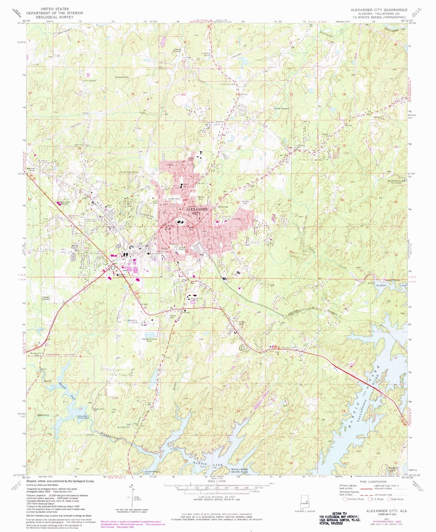
MyTopo
Classic USGS Alexander City Alabama 7.5'x7.5' Topo Map
Couldn't load pickup availability
Historical USGS topographic quad map of Alexander City in the state of Alabama. Map scale may vary for some years, but is generally around 1:24,000. Print size is approximately 24" x 27"
This quadrangle is in the following counties: Tallapoosa.
The map contains contour lines, roads, rivers, towns, and lakes. Printed on high-quality waterproof paper with UV fade-resistant inks, and shipped rolled.
Contains the following named places: Alabama State Troopers Highway Patrol, Alex City Holiness Church, Alexander City, Alexander City Christian Academy, Alexander City City Hall, Alexander City Division, Alexander City Fire Department Station 1, Alexander City Fire Department Station 2, Alexander City Middle School, Alexander City Police Department, Alexander City Post Office, Alexander City Post Offie, Alexander City Shopping Center, Alexander City State Junior College Dam, Andrew Jackson, Apostolic Temple Church, Avondale Mill School, Baptist Tabernacle Church, Bethel Cemetery, Bevelle, Blackman Creek, Calvary Heights Baptist Church, Carver Heights Cemetery, Central Alabama Community College, Christian Creek Sewage Disposal Plant, Church of Christ, Church of God, Church of God of Prophecy, City of Alexander City, Cobbs Allen and Hall Dam, Cobbs Allen and Hall Reservoir, Coley Creek, Coley Creek Sewage Disposal Plant, Comer Memorial Baptist Church, Comer Memorial Methodist Church, Craft Cemetery, Darain Baptist Church, Dobbs, Dobbs Sewage Disposal Plant, Double Bridges Park, Duncan, Duncan Community Center, Duncan Memorial United Methodist Church, Durian School, Early Rose Baptist Church, Elkahatchee Heights, Elkahatchee Park, Emmanual Church, Fellowship Cemetery, First Assembly of God Church, First Baptist Church, First Methodist Church, First Presbyterian Church, Flint Hill, Flint Hill Baptist Church, Flint Hill United Methodist Church, Fuller, Gordans Pond, Great Bethel Baptist Church, Hamp Lyon Stadium, Harper Cemetery, Haven Methodist Church, Hillabee Baptist Church, Hillview Cemetery, Hunt Memorial Congregational Church, Indian Hills, Jack Branch, Jim Pearson Junior High School, Junior College Lake, Kennedy - Christian - Sasser Cemetery, Kingdom Hall of Jehovahs Witnesses, Lake Hill Estates, Lake Hill Marina, Macedonia Cemetery, Macedonia Primitive Baptist Church, Miller Dam, Miller Lake, Moose Lodge Pond, Morningside, Mount Calvary Baptist Church, Nathaniel Stephens Elementary School, New Bethel Baptist Church, New Elkahatchee Baptist Church, Nolen Dam, Nolen Lake, O Street Baptist Church, Parish Hills, Pearson Chapel, Pearson Chapel United Methodist Church, Reeves, Ridge Grove Baptist Church, River Bend, River Road Baptist Church, Robinson Memorial Presbyterian Church, Russell High School, Russell Medical Center, Russell Mills Dam, Russell Pond, Saint James Episcopal Church, Saint John the Apostle Catholic Church, Saint Mark Missionary Baptist Church, Sanctified Church, Selena Baptist Church, Sherwood Forest, Sixth Street Baptist Church, Springhill Sewage Disposal Plant, Street Branch, Sugar Creek, Sugar Creek Filter Plant, Sunny Level, Sunny Level Baptist Church, Sunny Level Cemetery, Sunny Level United Methodist Church, Tallapoosa Sheriff's Office, Thomas C Russell Field, Trinity Methodist Church, Unity Baptist Church, Valley View, WACD-AM (Alexander City), Walls Dam, Walls Lake, Wayside Baptist Church, West End Baptist Church, West End Shopping Center, Westfield, Whortleberry Creek, William L Radney Elementary School, WRFS-AM (Alexander City), WRFS-FM (Alexander City), ZIP Code: 35010


