
MyTopo
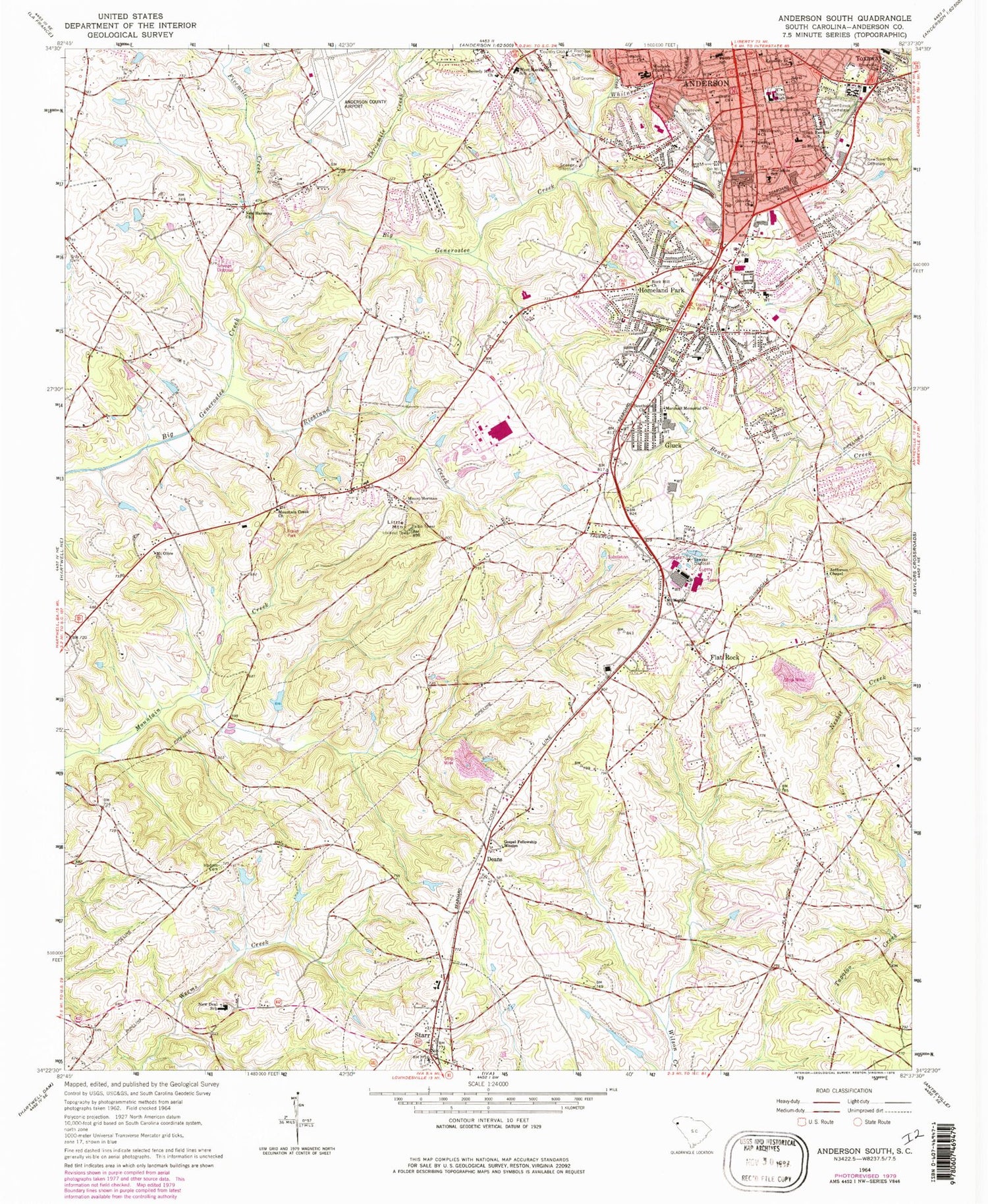
Classic USGS Anderson South South Carolina 7.5'x7.5' Topo Map
Couldn't load pickup availability
Historical USGS topographic quad map of Anderson South in the state of South Carolina. Typical map scale is 1:24,000, but may vary for certain years, if available. Print size: 24" x 27"
This quadrangle is in the following counties: Anderson.
The map contains contour lines, roads, rivers, towns, and lakes. Printed on high-quality waterproof paper with UV fade-resistant inks, and shipped rolled.
Contains the following named places: Boys High School, Dye Creek, Freewill Church, Gospel Fellowship Mission, Gray Cemetery, LaBoon Family Cemetery, Little Mountain, Marshall Memorial Church, New Harmony Church, New Silver Brook Cemetery, Orr Mill Park, Orr Mill Cemetery, Perry School, Richland Creek, Silver Brook Cemetery, Southside School, West Market Street School, Westside High School, Westview Cemetery, Whitner Creek, Gluck, Homeland Park, Toxaway, Bethel African Methodist Episcopal Church, Beverly Hills, Caldwell Village, Calhoun Hills, Carolina Springs, River Street Baptist Church, River Street Plaza Shopping Center, Rocky Branch, Rucker Court, Smith Chapel Methodist Church (historical), Soul Deliverance Center, South Anderson Baptist Chapel, Southgate Shopping Center, Southwood Middle School, Southwood Park, Starr Baptist Church, Starr Elementary School, Starr Methodist Church, Taylors School (historical), United House of Prayer for All People, Vandale Place, Varennes Heights Baptist Church, Watson Village Shopping Center, Watsons Mill (historical), Wellington Pentecostal Holiness Church, Westview Heights, White Street Park, Zion Pentecostal Holiness Church, American Legion Memorial Athletic Field, Anderson Country Club, Anderson Mennonite Church, Fant Street Graded School (historical), Pentecostal Holiness Church, Chambert Forest, Chamblees Mill (historical), Cherokee Farms, Christian Fellowship Outreach, Christopher Heights, Clover Hill, Cloverdale, Deans Presbyterian Church (historical), Durham Shopping Center, Eastpoint Shopping Center, Fernwood, First Assembly of God Church, Flat Rock Baptist Church, Flat Rock Church, Flat Rock School (historical), Gladstone Acres, Grace Episcopal Church, Green Acres, Greenbriar, Haynies Mill (historical), Homeland Park Baptist Church, Homeland Park Church of God, Homeland Park Elementary School, Homeland Park - John Wesley United Methodist Church, Indian Trail, Lyonswood, Meadow Fields, Meadow Park, Mount Hermon School (historical), Mount Moriah School (historical), Mountain Creek, Mountain Creek School (historical), Old Bethesda Methodist Church (historical), Chamblee Pond Dam D-3111, Dobbins Pond Dam D-3116, Glenn Pond Number One D-3109 Dam, Glenn Pond Dam Number Two D-3108, Hill Pond Dam D-3110, Strickland Pond Dam D-3117, Grace Church, Hodges Cemetery, Jefferson Chapel, Kennedy Street School, Victory Baptist Church, Deans, Fivemile Creek, Flat Rock, Mount Carmel Church, Mount Herman Baptist Church, Mount Moriah Baptist Church, Mount Olive Baptist Church, Mountain Creek Baptist Church, New Deal School, Orrville Baptist Church, Riverside Baptist Church, Rock Hill Baptist Church, Royal Baptist Church, Saint Marys Church, Salem Church, South Fant Street School, Southside Baptist Church, Starr, Threemile Creek, Wesleyan Church, Pine Forest, Saint Paul First Baptist Church, Varennes Elementary School, Varennes Heights, Orrville United Methodist Church, Anderson Regional Airport, Mountain Creek Post Office (historical), WRIX-AM (Homeland Park), Anderson Division, Anderson Army Air Field (historical), Byrum - LeBoon Family Cemetery, Homeland Park Census Designated Place, Town of Starr, Hardy Berry Farm, Anderson County Fire Department Homeland Park Station 3, McAlister Greenhouses


