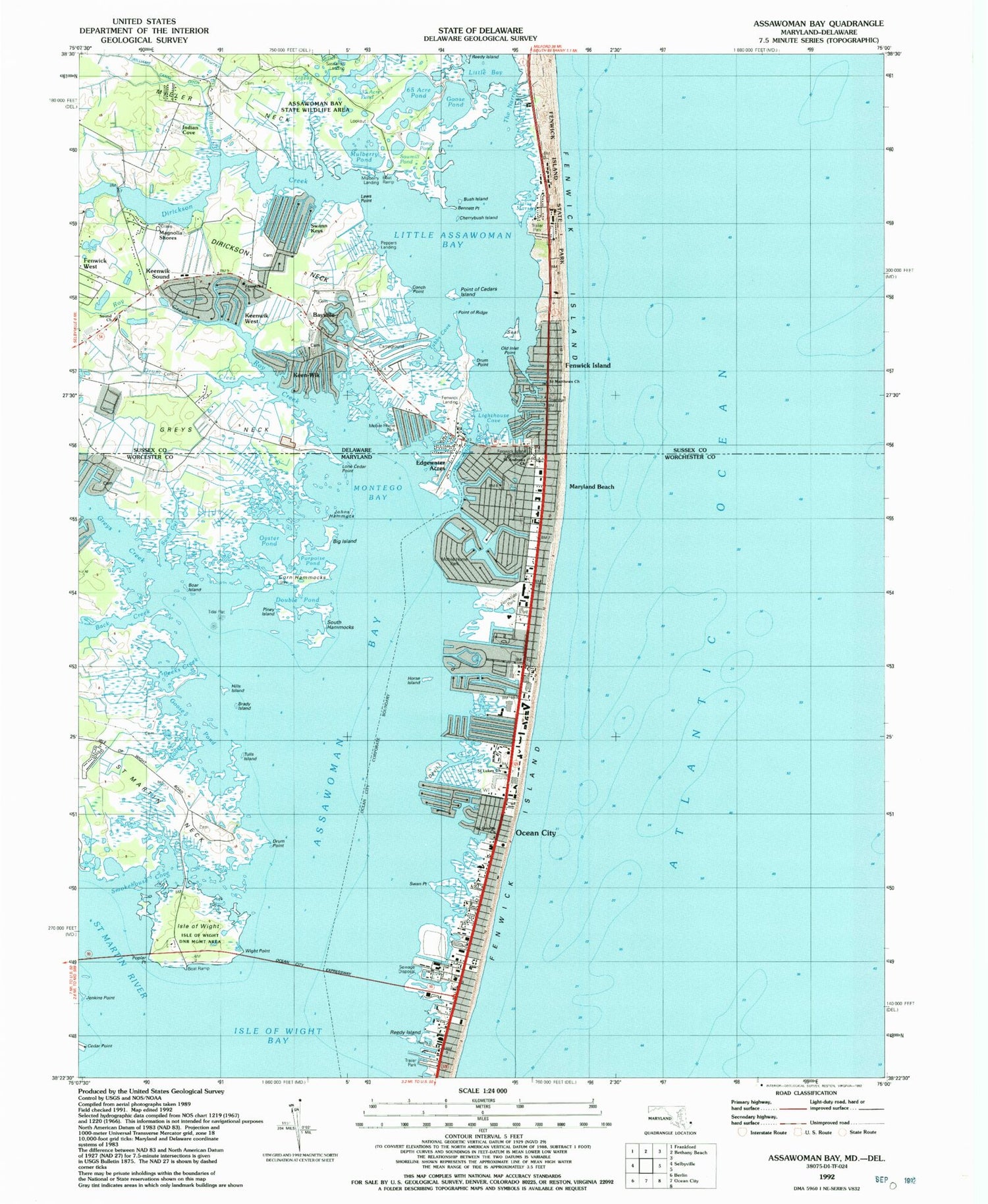

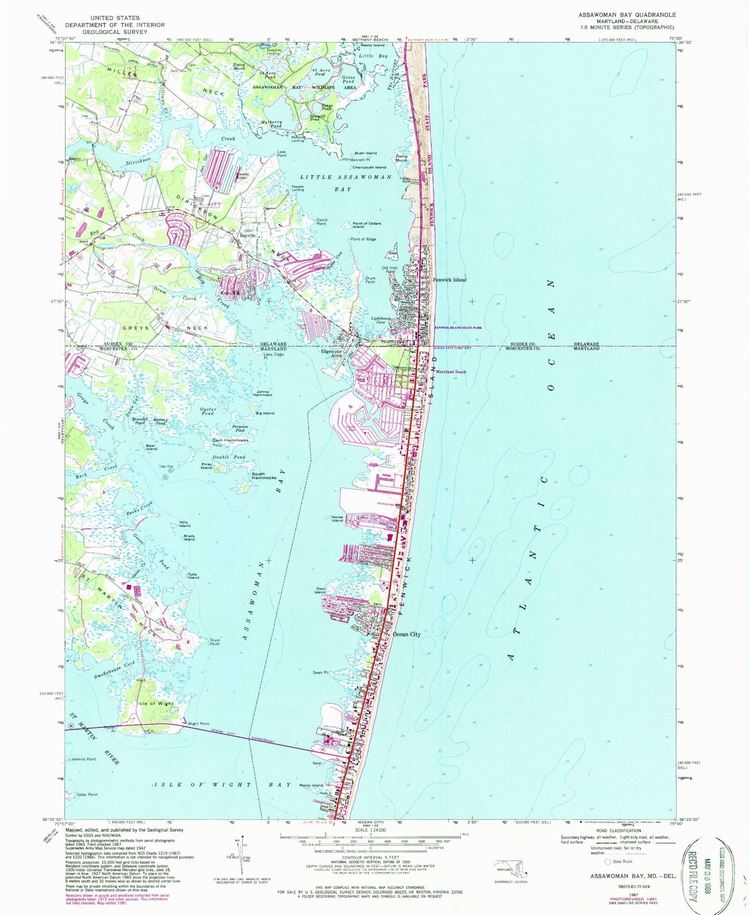
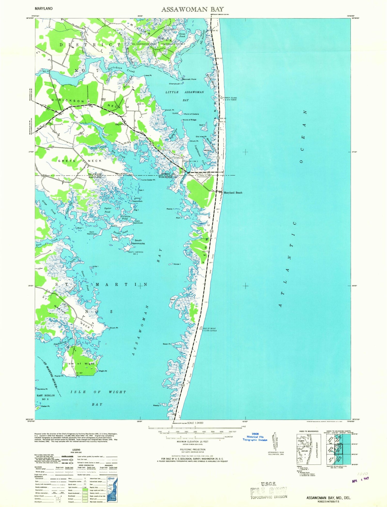

MyTopo
Classic USGS Assawoman Bay Maryland 7.5'x7.5' Topo Map
Couldn't load pickup availability
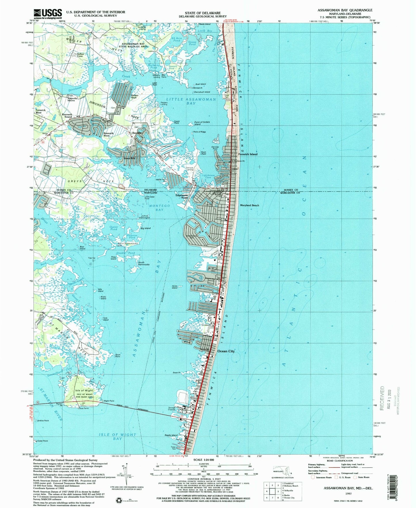
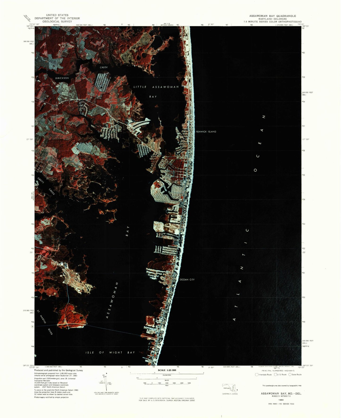
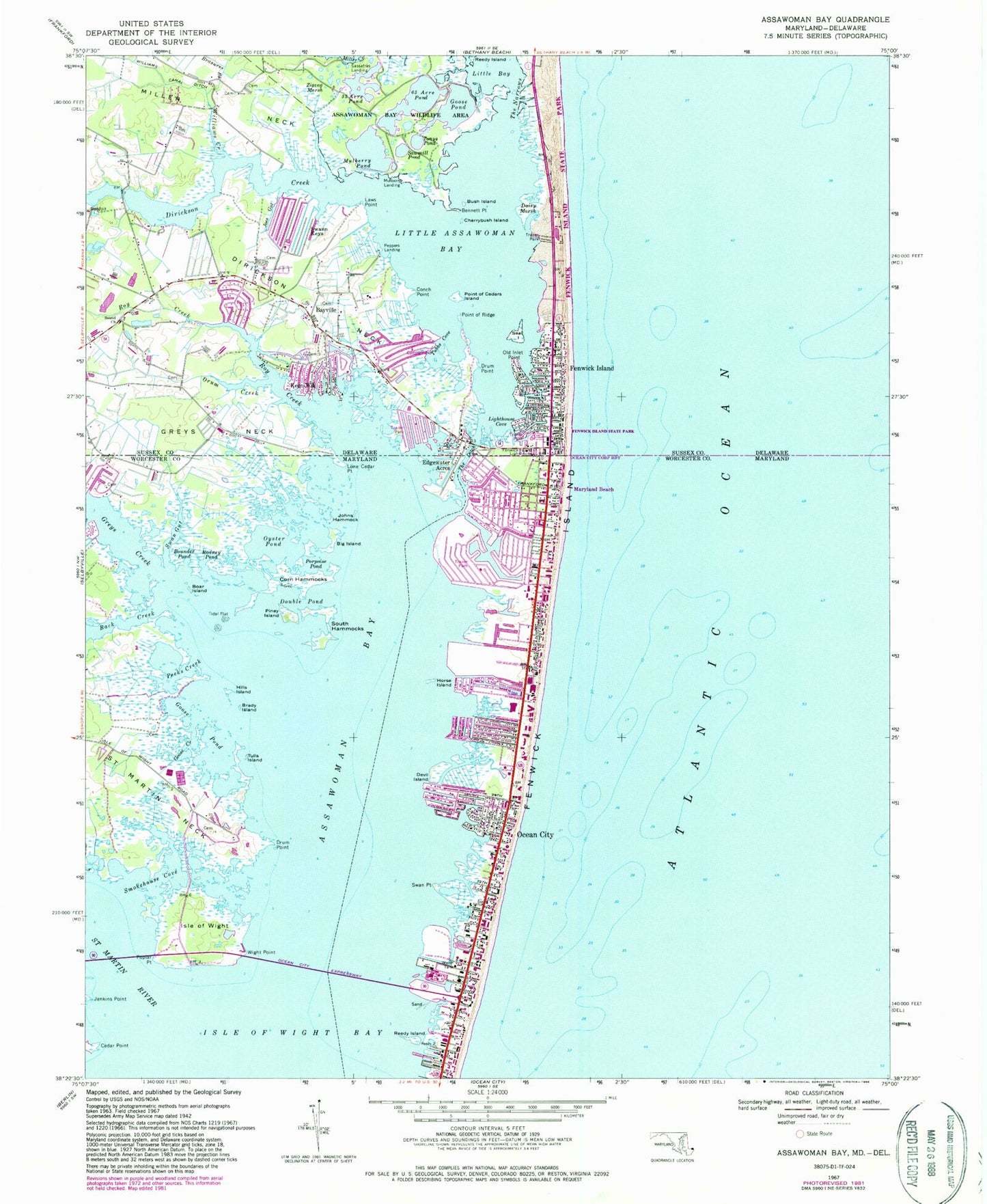
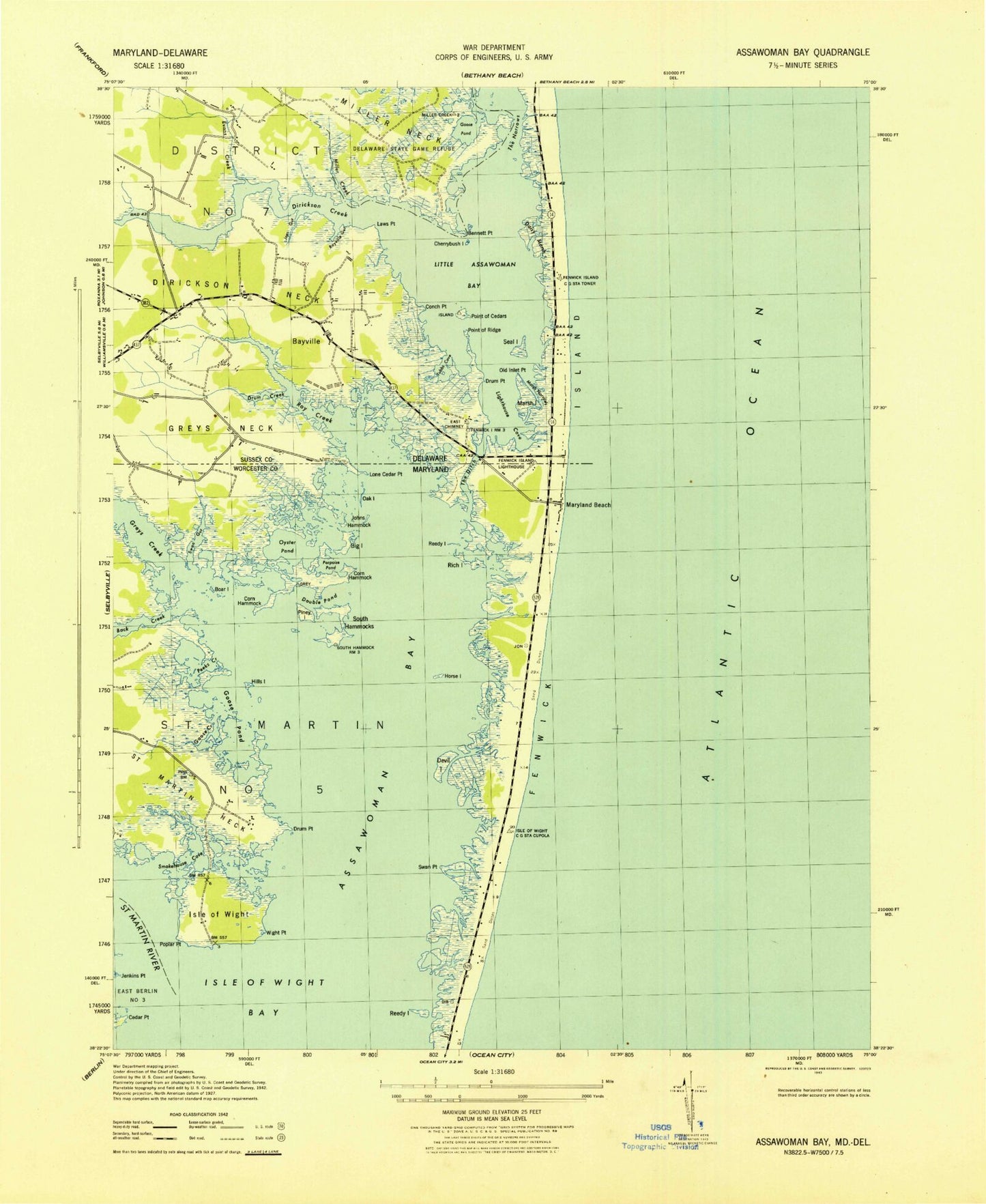
Historical USGS topographic quad map of Assawoman Bay in the states of Maryland, Delaware. Typical map scale is 1:24,000, but may vary for certain years, if available. Print size: 24" x 27"
This quadrangle is in the following counties: Sussex, Worcester.
The map contains contour lines, roads, rivers, towns, and lakes. Printed on high-quality waterproof paper with UV fade-resistant inks, and shipped rolled.
Contains the following named places: Assawoman Bay, Back Creek, Big Island, Boar Island, Brady Island, Cedar Point, Corn Hammocks, Devil Island, Double Pond, Drum Point, Goose Creek, Goose Pond, Greys Creek, Hills Island, Horse Island, Jenkins Point, Johns Hammock, Lone Cedar Point, Maryland Beach, Oyster Pond, Peeks Creek, Piney Island, Poplar Point, Porpoise Pond, Reedy Island, Rodney Pond, Saint Martin Neck, Saint Martin River, Smokehouse Cove, South Hammocks, Swan Gut, Swan Point, The Ditch, Tulls Island, Wight Point, Saint Andrews Catholic Church, Saint George Greek Orthodox Church, Saint Lukes Catholic Church, Isle of Wight Department of Natural Resources Management Area, Northside Park, Edgewater Acres, Isle of Wight, Assawoman Bay Bridge, Bayside Keys, Caine Harbor Mile, Caine Keys, Cainwoods, Fenwick, Gold Coast Mall Shopping Center, Gorman Avenue Park, Hidden Harbor, Isle of Wight Medical Center, Isle of Wight Natural Resources Management Area, Montego Bay, Montego Bay Mobile Home Park, Montego Bay Shopping Center, Montego Station Ocean City Post Office (historical), Ninetythird Street Medical Center, North Ocean City Station Ocean City Post Office (historical), Oak Island (historical), Ocean Bay City, Ocean Plaza Mall Shopping Center, Peninsula General Health Services (historical), Reedy Island (historical), Rich Island (historical), Sixtyfirst Street Park, Ocean City Post Office, District 7 Ocean City, Ocean City Volunteer Fire Company Station 3, Ocean City Volunteer Fire Company Station 4, Ocean City Police Department, Town of Ocean City, Advanced Marina, Links at Lighthouse Sound, Ocean City District Courthouse, Ocean City Square Shopping Center, Ocean City Wastewater Treatment Plant, Warrens Park, Town of Ocean City Public Safety Building, Bayville, Bennett Point, Brasures Branch, Bush Island, Cherrybush Island, Conch Point, Daisy Marsh, Dirickson Creek, Dirickson Neck, Drum Creek, Drum Point, Fenwick Island, Fenwick Island, Fenwick Island Lighthouse, Goose Pond, Greys Neck, Joes Gut, Keen-Wik, Laws Point, Lighthouse Cove, Little Assawoman Bay, Miller Neck, Mulberry Pond, Old Inlet Point, Point of Ridge, Roy Creek, Sawmill Pond, Seal Island, Sixty Five Acre Pond, Sound Church, The Narrows, Tonys Pond, Tubbs Cove, Williams Canal Ditch, Williams Creek, Zigzag Marsh, Fenwick Landing, Keenwik West, Teaberry Woods, Fenwick West, Keenwik Sound, Magnolia Shores, Tinks Landing, Sea Dunes, Seatowne, Oak Acres, Indian Cove, Kings Grant, Queens Quest, Seaside Villas, The Shoals, Mulberry Landing, Peppers Landing, Sassafras Landing, Swann Keys, Cape Windsor Mobile Home Park, Shady Park Mobile Home Park, Bayville Gut, Miller Creek, Fenwick Island State Park, The Ditch, Marsh Narrows, Mattapany (historical), Saint Matthews by the Sea United Methodist Church, Thirty-five Acre Pond, Assawoman Bay State Wildlife Area, Point of Cedars Island, Point of Cedars (historical), Marsh Island (historical), Fenwick Estates, The Narrows, Fenwick Island Police Department, Town of Fenwick Island, Roxanna Fire Department Ambulance Station, Bethany Beach Volunteer Fire Company Station 2, Olivers Point, Assawoman Bay, Back Creek, Big Island, Boar Island, Brady Island, Cedar Point, Corn Hammocks, Devil Island, Double Pond, Drum Point, Goose Creek, Goose Pond, Greys Creek, Hills Island, Horse Island, Jenkins Point, Johns Hammock, Lone Cedar Point, Maryland Beach, Oyster Pond, Peeks Creek, Piney Island, Poplar Point, Porpoise Pond, Reedy Island, Rodney Pond, Saint Martin Neck, Saint Martin River, Smokehouse Cove, South Hammocks, Swan Gut, Swan Point, The Ditch, Tulls Island, Wight Point, Saint Andrews Catholic Church, Saint George Greek Orthodox Church, Saint Lukes Catholic Church, Isle of Wight Department of Natural Resources Management Area, Northside Park, Edgewater Acres, Isle of Wight, Assawoman Bay Bridge, Bayside Keys, Caine Harbor Mile, Caine Keys, Cainwoods, Fenwick, Gold Coast Mall Shopping Center, Gorman Avenue Park, Hidden Harbor, Isle of Wight Medical Center, Isle of Wight Natural Resources Management Area, Montego Bay, Montego Bay Mobile Home Park, Montego Bay Shopping Center, Montego Station Ocean City Post Office (historical), Ninetythird Street Medical Center, North Ocean City Station Ocean City Post Office (historical), Oak Island (historical), Ocean Bay City, Ocean Plaza Mall Shopping Center, Peninsula General Health Services (historical), Reedy Island (historical), Rich Island (historical), Sixtyfirst Street Park, Ocean City Post Office, District 7 Ocean City, Ocean City Volunteer Fire Company Station 3, Ocean City Volunteer Fire Company Station 4, Ocean City Police Department, Town of Ocean City, Advanced Marina, Links at Lighthouse Sound, Ocean City District Courthouse, Ocean City Square Shopping Center, Ocean City Wastewater Treatment Plant, Warrens Park, Town of Ocean City Public Safety Building, Bayville, Bennett Point