
MyTopo
Classic USGS Athol Massachusetts 7.5'x7.5' Topo Map
Couldn't load pickup availability
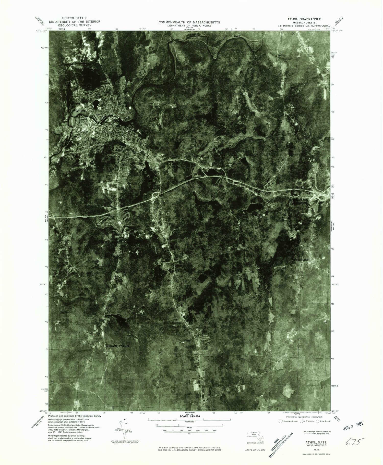
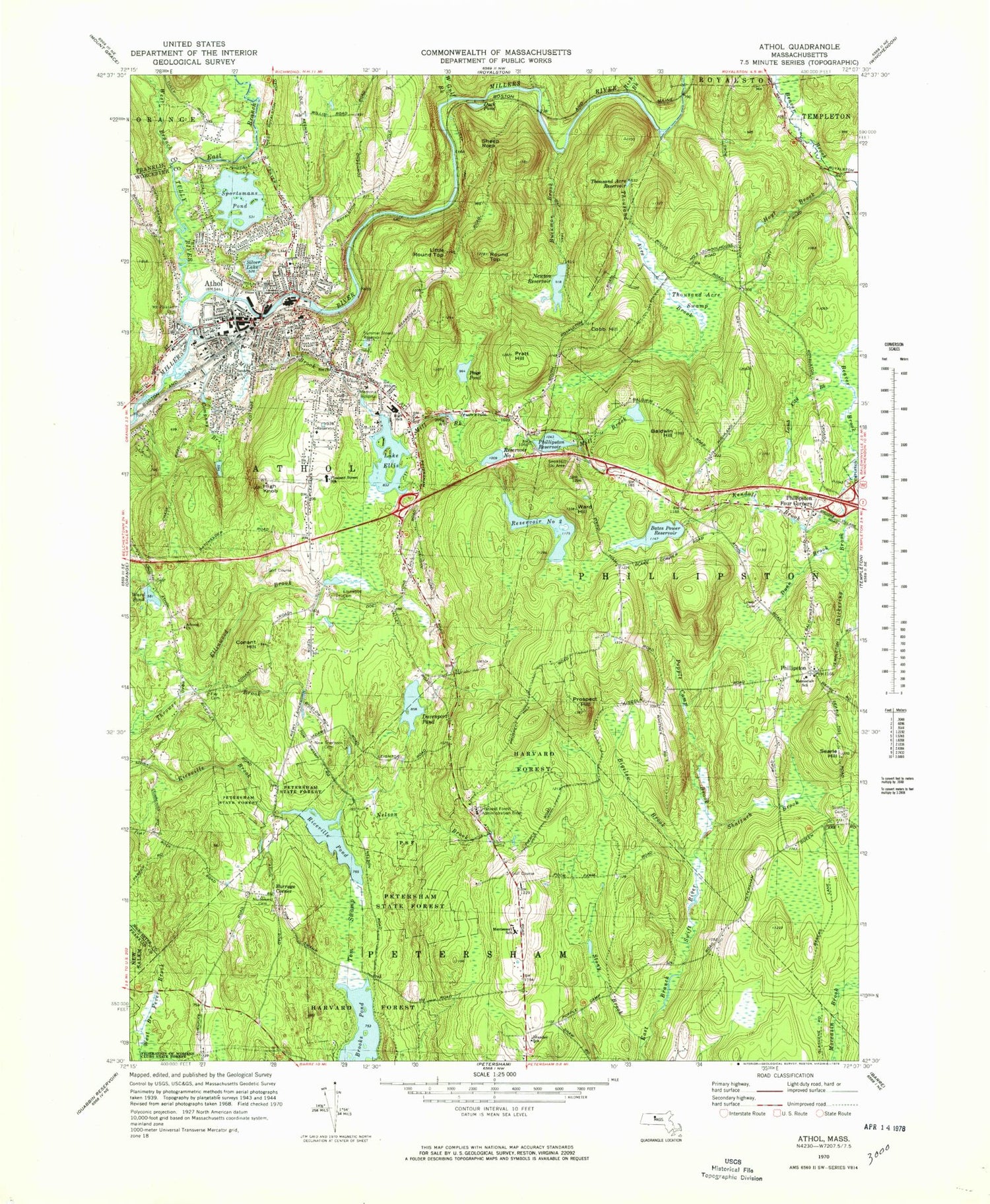
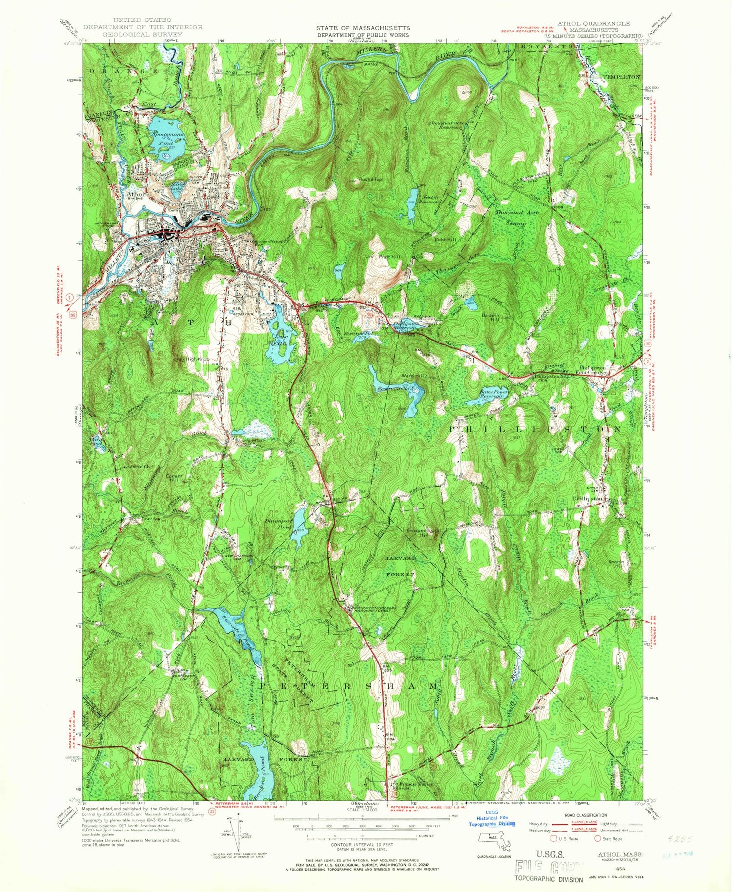
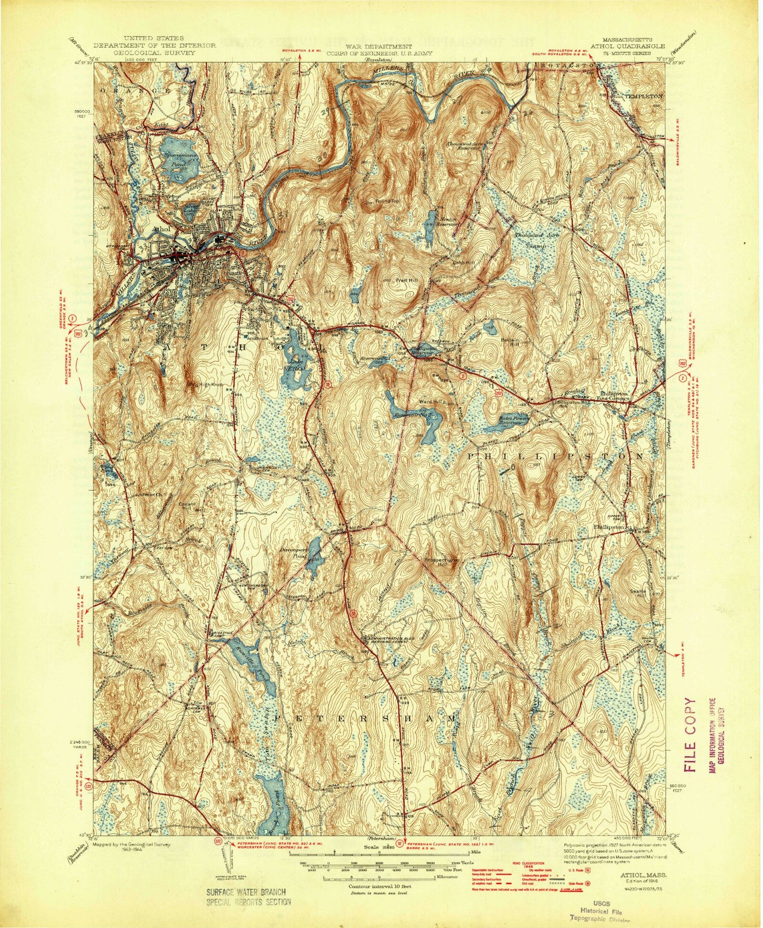
Historical USGS topographic quad map of Athol in the state of Massachusetts. Typical map scale is 1:24,000, but may vary for certain years, if available. Print size: 24" x 27"
This quadrangle is in the following counties: Franklin, Worcester.
The map contains contour lines, roads, rivers, towns, and lakes. Printed on high-quality waterproof paper with UV fade-resistant inks, and shipped rolled.
Contains the following named places: Saint Stanislaus Cemetery, Sanders School, Mount Pleasant Cemetery, Athol High School, Highland Cemetery, Phillipston Memorial Elementary School, New Sherborn Cemetery, Ellinwood Cemetery, Advent Church, Fay Cemetery, Calvary Cemetery, South Cemetery, Silver Lake Cemetery, Petersham State Forest, Harvard Forest, Lower Cemetery, Northwest Cemetery, Montessori School, Harvard Forest Administration Building, Pleasant Street School, Memorial Hospital, Riceville Pond Dam, Bates Power Reservoir Dam, Reservoir Dam Number Two, Phillipston Reservoir Dam, Lake Ellis Dam, Athol Manufacturing Dam, Millers River Reservoir, Millers River Reservoir, Crescent Street Dam, Newton Reservoir Dam, Sportsmans Pond Dam, Athol High School, Athol Junior High School, Ellen Bigelow School, Silver Lake School, Paige Pond, Ice Company Branch, Riverbend School, Fish Park, Phillipston Wildlife Management Area, Popple Camp State Wildlife Management Area, Brandon School (historical), Athol, Baldwin Hill, Bates Powers Reservoir, Bigelow Brook, Harvard Pond, Buckman Brook, Chickering Brook, Cobb Hill, Company Brook, Conant Hill, Davenport Pond, Dunn Brook, East Branch Tully River, Lake Ellis, Gulf Brook, High Knob, Hoyt Brook, Kendall Brook, Lamb City Brook, Mill Brook, Nelson Brook, Newton Reservoir, Phillipston, Phillipston Four Corners, Phillipston Reservoir, Popple Camp Brook, Pratt Hill, Prospect Hill, Reservoir Number One, Reservoir Number Two, Riceville Pond, Rich Brook, Round Top, Searle Hill, Shattuck Brook, Silver Lake, Sportsmans Pond, Stony Brook, Summer Street Reservoir, Thousand Acre Brook, Thousand Acre Reservoir, Thousand Acre Swamp, Tom Swamp, Tully River, Ward Hill, Ward Pond, West Branch Tully River, West Gulf Brook, Silver Lake, Burrage Corner, Duck Pond, Little Round Top, Sheep Rock, Pinedale, The Street, Town of Athol, Town of Phillipston, WCAT-FM (Athol), Athol-Orange Baptist Church, Athol Post Office, Ellinwood Country Club, First Church Unitarian Church, Memorial Hall, Old Town Hall, Phillips Free Public Library, Phillipston Congregational Church, Saint Francis of Assisi Church, Saint Johns Episcopal Church, Starrett Memorial Methodist Church, Athol Hospital, Athol-Royalston Middle School, Athol Census Designated Place, Red Apple Farm, Athol Fire Department Station 1, Phillipston Fire Department, Athol Fire Department Station 2 Headquarters, Athol Police Department, Phillipston Police Department, Massachusetts State Police Station C1 Athol Barracks, Arthur Brook, Saint Stanislaus Cemetery, Sanders School, Mount Pleasant Cemetery, Athol High School, Highland Cemetery, Phillipston Memorial Elementary School, New Sherborn Cemetery, Ellinwood Cemetery, Advent Church, Fay Cemetery, Calvary Cemetery, South Cemetery, Silver Lake Cemetery, Petersham State Forest, Harvard Forest, Lower Cemetery, Northwest Cemetery, Montessori School, Harvard Forest Administration Building, Pleasant Street School, Memorial Hospital, Riceville Pond Dam, Bates Power Reservoir Dam, Reservoir Dam Number Two, Phillipston Reservoir Dam, Lake Ellis Dam, Athol Manufacturing Dam, Millers River Reservoir, Millers River Reservoir, Crescent Street Dam, Newton Reservoir Dam, Sportsmans Pond Dam, Athol High School, Athol Junior High School, Ellen Bigelow School, Silver Lake School, Paige Pond, Ice Company Branch, Riverbend School, Fish Park, Phillipston Wildlife Management Area, Popple Camp State Wildlife Management Area, Brandon School (historical), Athol, Baldwin Hill, Bates Powers Reservoir, Bigelow Brook, Harvard Pond, Buckman Brook, Chickering Brook, Cobb Hill, Company Brook, Conant Hill, Davenport Pond, Dunn Brook, East Branch Tully River, Lake Ellis, Gulf Brook, High Knob, Hoyt Brook, Kendall Brook, Lamb City Brook, Mill Brook, Nelson Brook, Newton Reservoir, Phillipston, Phillipston Four Corners, Phillipston Reservoir, Popple Camp Brook, Pratt Hill, Prospect Hill, Reservoir Number One, Reservoir Number Two, Riceville Pond, Rich Brook, Round Top, Searle Hill, Shattuck Brook, Silver Lake, Sportsmans Pond, Stony Brook, Summer Street Reservoir, Thousand Acre Brook, Thousand Acre Reservoir, Thousand Acre Swamp, Tom Swamp, Tully River, Ward Hill, Ward Pond, West Branch Tully River, West Gulf Brook, Silver Lake, Burrage Corner, Duck Pond, Little Round Top, Sheep Rock, Pinedale, The Street, Town of Athol, Town of Phillipston, WCAT-FM (Athol), Athol-Orange Baptist Church, Athol Post Office, Ellinwood Country Club, First Church Unitarian Church, Memorial Hall, Old Town Hall, Phillips Free Public Library, Phillipston Congregational Church, Saint Francis of Assisi Church, Saint Johns Episcopal Church, Starrett Memorial Methodist Church, Athol Hospital


