MyTopo
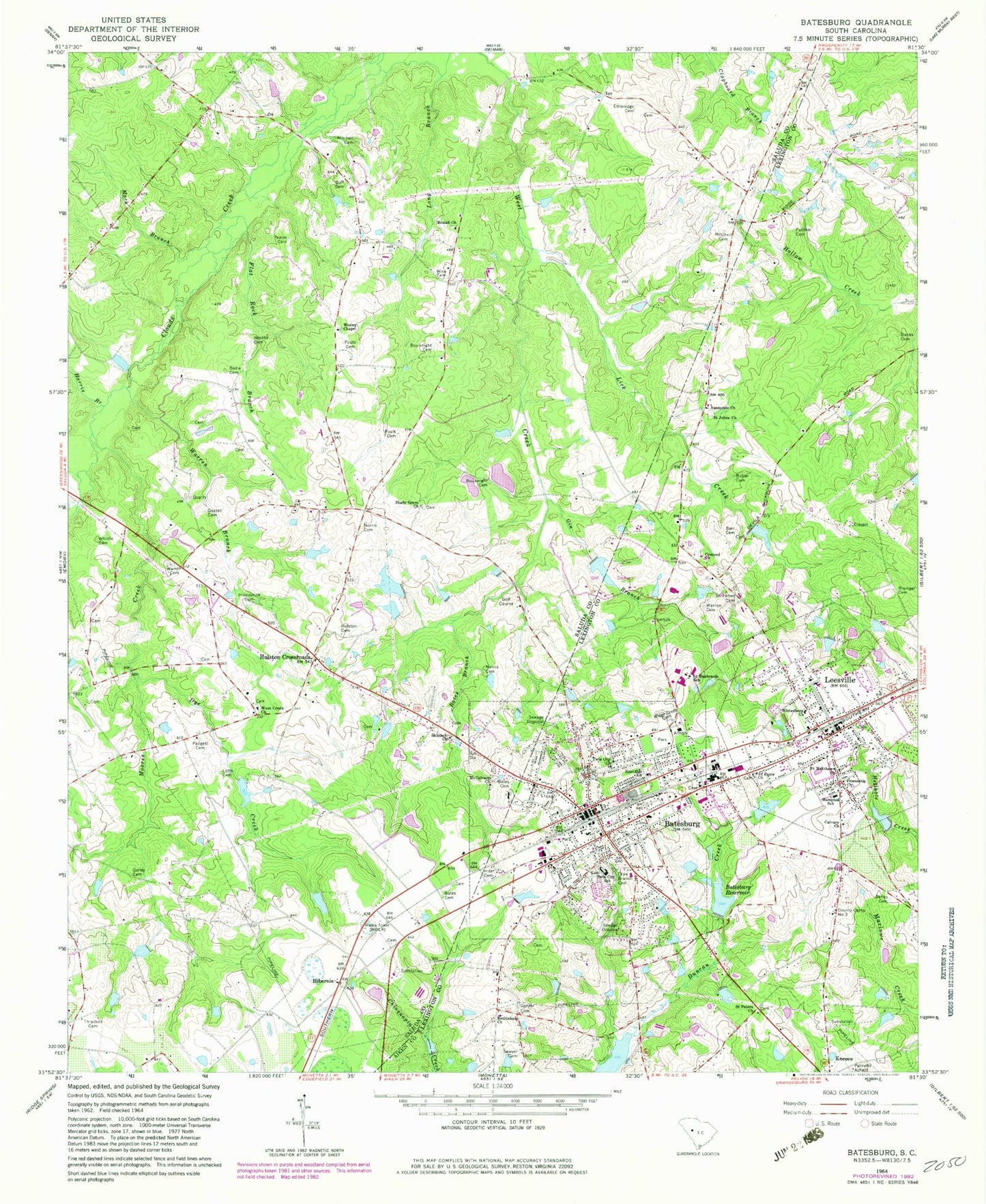
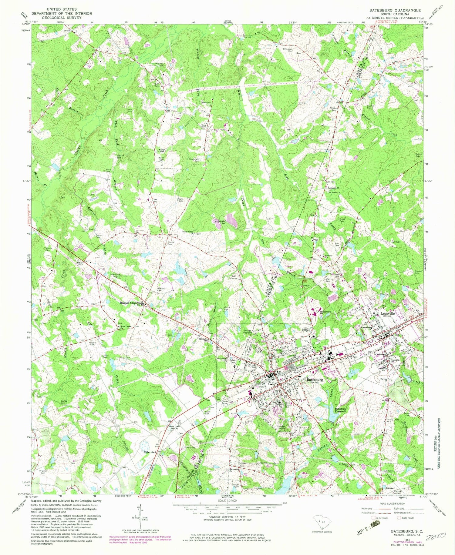
Classic USGS Batesburg South Carolina 7.5'x7.5' Topo Map
Couldn't load pickup availability
Historical USGS topographic quad map of Batesburg in the state of South Carolina. Map scale may vary for some years, but is generally around 1:24,000. Print size is approximately 24" x 27"
This quadrangle is in the following counties: Aiken, Lexington, Saluda.
The map contains contour lines, roads, rivers, towns, and lakes. Printed on high-quality waterproof paper with UV fade-resistant inks, and shipped rolled.
Contains the following named places: Amick Farms, Asbill Cemetery, Banks Cemetery, Barr Cemetery, Bates Branch, Bates Cemetery, Batesburg, Batesburg - Leesville Fire Department Station 25, Batesburg - Leesville Fire Department Station 26, Batesburg - Leesville Police Department, Batesburg - Leesville Rescue Squad, Batesburg Commercial Historic District, Batesburg Reservoir, Batesburg Saluda School, Batesburg-Leesville, Batesburg-Leesville Division, Batesburg-Leesville Elementary School, Batesburg-Leesville High School, Batesburg-Leesville Middle School, Batesburg-Leesville Primary School, Bethlehem Church, Beulah Church, Bodie Cemetery, Bouknight Cemetery, Butler Cemetery, Calvary Church, Church of God, Church Street Historic District, Clyde School, Concord Church, Corley Cemetery, County Camp Number Three, Davis Pond, Dye Creek, East Side Church, Etheredge Cemetery, Etheridge School, Faith Lutheran Church, First Baptist Church of Batesburg, First Baptist Church of Leesville, Flat Rock Branch, Foulk Cemetery, Fouts Cemetery, Fricks Pond, Fricks Pond Dam D-0842, Friendship Church, Fullmer Cemetery, Gin Branch, Gosset Cemetery, Gunter Cemetery, Hampton School, Harris Branch, Hibernia, Hibernian Church, Hite Cemetery, Holston Cemetery, Holston Crossroads, J A Holmes Pond, J A Holmes Pond Dam D-1199, James Butler Bonham Academy, Leesville, Leesville College Historic District, Leesville United Methodist Church, Lick Creek, Lotts Cemetery, Lucy Lockett Church, Mack Branch, Middleburg Methodist Church, Mitchell Cemetery, Mitchell Plaza Shopping Center, Moores Creek, Mount Calvary Church, Mount Zion Baptist Church, Norris Cemetery, Olive Branch Cemetery, Padgett Cemetery, Ponderosos Pond, Ponderosos Pond Dam D-1154, Prater Cemetery, Providence Cemetery, Providence Church, Providence School, Ridge Crest Cemetery, Ridge Road School, Risinger Cemetery, Saint Euphrasia School, Saint James Cemetery, Saint James Christian Methodist Episcopal Church, Saint Johns Church, Saint Johns United Methodist Church, Saint Matthews Church, Saint Pauls Church, Saint Pauls Episcopal Church, Saint Peters Lutheran Church, Sawyer Cemetery, Shady Grove Church, Skipjack Church, South Carolina Noname 32065 D-0930 Dam, South Carolina Noname 32099 D-0931 Dam, South Carolina Noname 32105 D-1042 Dam, South Carolina Noname 41004 D-1195 Dam, Sunnyside Church, Thraikill Cemetery, Tillman School, Town of Batesburg-Leesville, Twin City Church, Twin City School, Warren Branch, Warren Cemetery, WBLR-AM (Batesburg), Wesley Chapel, West Creek Church, Whittle Cemetery, Wise Cemetery, Wises Pond, Wises Pond Dam D-1604, Wittenberg Lutheran Church