MyTopo
Classic USGS Bernardsville New Jersey 7.5'x7.5' Topo Map
Couldn't load pickup availability
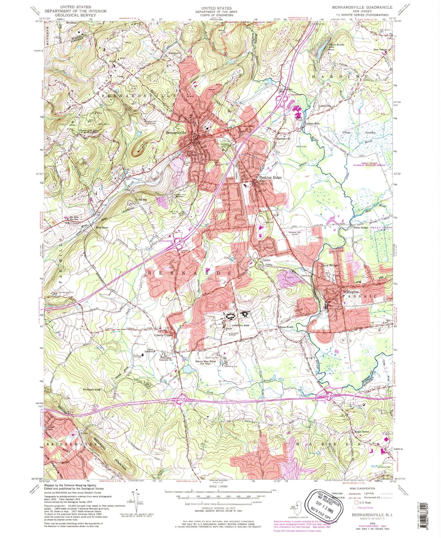
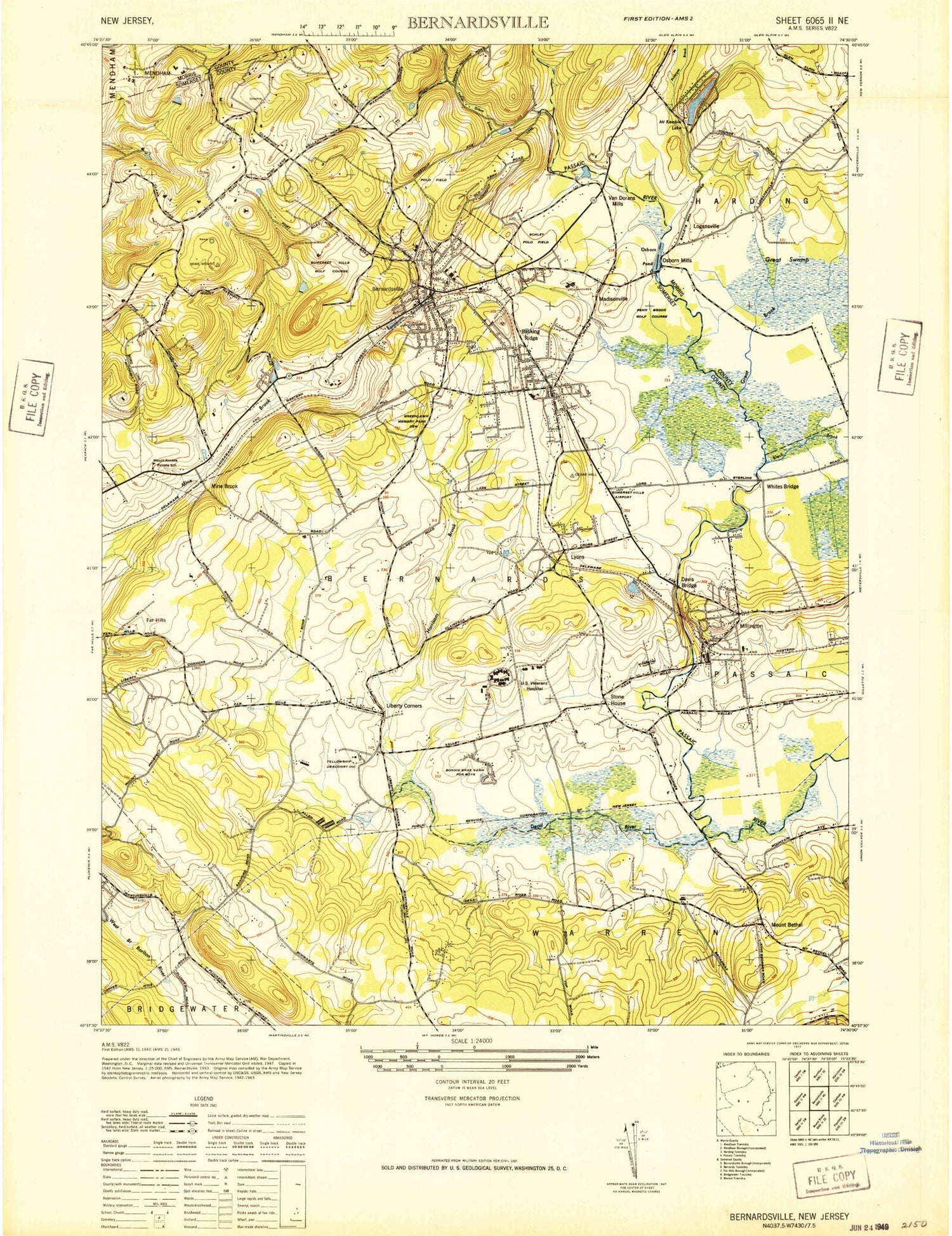
Historical USGS topographic quad map of Bernardsville in the state of New Jersey. Typical map scale is 1:24,000, but may vary for certain years, if available. Print size: 24" x 27"
This quadrangle is in the following counties: Morris, Somerset.
The map contains contour lines, roads, rivers, towns, and lakes. Printed on high-quality waterproof paper with UV fade-resistant inks, and shipped rolled.
Contains the following named places: Basking Ridge, Bernardsville, Black Brook, Bonnie Brae School, Camp Sunshine, Church of Saint John of the Mountain, Corys Brook, Davis Bridge, Dead River, Far Hills Country Day School, Fellowship Deaconry, Great Brook, Harrisons Brook, Holy Cross Cemetery, Indian Grave Brook, Liberty Corner, Logansville, Lyons, Madisonville, Millington, Mine Brook, Mine Mountain, Mount Kemble Lake, New Vernon Cemetery, Osborn Mills, Osborn Pond, Penns Brook, Pill Hill, Primrose Brook, Somerset Hills Cemetery, Spring Brook, Stone House, Van Dorans Mills, White Bridge, Woodcastle School, Township of Warren, Township of Bernards, Somerset Hills Airport (historical), Still Pond (historical), Mount Bethel, Somersetin, Van Dorans Mill Pond, Van Dorans Mill Dam, Mount Kemble Lake Dam, Somerset Hills Golf Course, One Hundred and Ninetyfive Broadway Corporation, AT and T Helistop, Borough of Bernardsville, Harding Township Elementary School, Millington Elementary School, Saint Vincent De Paul Catholic Cemetery, Roxiticus Golf Club, Blaziers Corner, Mount Bethel Baptist Church, Liberty Corner Presbyterian Church, Bernardsville United Methodist Church, Gatekeepers Ministries, Saint Bernard's Episcopal Church, Bishop Janes United Methodist Church, Saint Mark's Episcopal Church, Bedwell Elementary School, Bernards High School, Bernardsville Middle School, Cedar Hill Elementary School, Hamilton Elementary School, Liberty Corner Elementary School, Oak Street Elementary School, Ridge High School, William Annin Middle School, Penn Brook Golf Course, Bernardsville Methodist Cemetery, Evergreen Cemetery, Millington Baptist Cemetery, Mount Bethel Cemetery, Saint Bernards Cemetery, Lord Sterling Park, Leonard J Buck Gardens, Olcott Square, Schmidt Park, Schley Polo Field (historical), Environmental Montessori School, Palmer School, Mount Prospect Elementary School, Somerset Hills School, Mendham Country Day School, Saint James School, Zimmer Preschool, Saint Martins School, Goddard School, Developmental Learning Center School - Warren, Albrook Montessori School, School of Saint Elizabeth, Somerset Hills Montessori School, Lord Stirling School, Ripple Hill Farm, Wightman's Farm, Middle Valley Farm, Millington Quarry, Bernardsville Fire Company, Harding Township Fire Department, Martinsville Volunteer Fire Department Station 2, Warren Township Fire Department - Mount Horeb Volunteer Fire Company 2, Liberty Corner Fire Company, Millington Fire Department, Basking Ridge Fire Company 1 and First Aid Squad, Lyons Fire Department, Veterans Affairs Medical Center, Liberty Corner First Aid Squad, Bernards Township Police Department, Bernardsville Police Department, Lyons Post Office, Vail Family Burial Ground, Warren Post Office, Basking Ridge Post Office, Village Post Office, Liberty Corner Post Office, Millington Post Office, Bernardsville Post Office, Liberty Corner Census Designated Place, Lyons Census Designated Place, Millington Census Designated Place, The Hills, The Hills Census Designated Place, Basking Ridge Census Designated Place