MyTopo
Classic USGS Cairo Alabama 7.5'x7.5' Topo Map
Couldn't load pickup availability
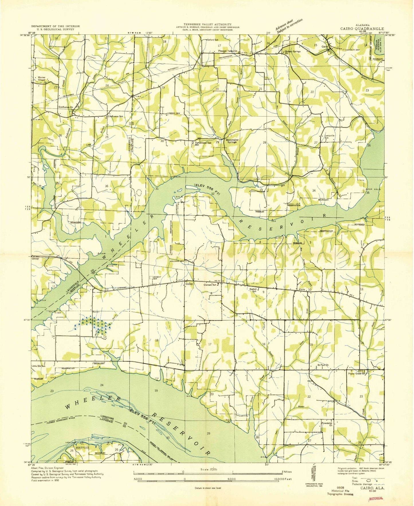
Historical USGS topographic quad map of Cairo in the state of Alabama. Typical map scale is 1:24,000, but may vary for certain years, if available. Print size: 24" x 27"
This quadrangle is in the following counties: Lauderdale, Lawrence, Limestone.
The map contains contour lines, roads, rivers, towns, and lakes. Printed on high-quality waterproof paper with UV fade-resistant inks, and shipped rolled.
Contains the following named places: Plato Branch, Allison Hollow, Bald Eagle Hollow, Barker Cemetery, Bedingfield Cemetery, Beechwood Branch, Big Branch, Blue Springs Branch, Boiling Spring, Brooks Cemetery, Bud Graham Bluff, Buzzard Roost Bluff, Cairo, Cannon Hollow, Cave Spring, Cedar Grove, Clement School, Confluence Methodist Church, Confluence School, Coxey, Coxey Creek, Dement Branch, Dement Cemetery, Dement Creek, Dog Hollow, Dry Branch, Friend Branch, Friendship Church, Greer Cemetery, Grimm Spring, Hamilton Spring Branch, Hardy Cemetery, Harper Bluff, Higgens Cemetery, Hooie - Bedingfield Cemetery, Hudson Cemetery, Ivy Bluff, Lawrence County Park, Legg Branch, Legg Cemetery, Lentzville Branch, Lentzville Cemetery, Little Elk Church, Little Elk School, Lucy Cemetery, Maple Swamp Branch, Melton Bluff, Mill Branch, Miller Cemetery, Mount Perrin Church, Petty Branch, Pleasant Valley School, Poplar Springs Branch Cabin Site Area, Ripley Cemetery, Rocky Branch, Romine Branch, Rutherford Cemetery, Sandlin Cemetery, Shoemaker Cemetery, Shoemaker Spring, Stanford Branch, Stewart Branch, Stewart Ferry Cabin Site Area, Tanyard Branch, Temperance Oak Church, Townsend Cemetery, Wallace Cemetery, Warner Chapel, Wheeler Reservoir, Yarbrough Cemetery, Chigger Island (historical), Beachwood School (historical), Blue Springs Park, Cairo Church, Cairo Church, Coxey Church, Elk Estates, Elk River Lodge State Park, Elk River Memorial Gardens, Gilchrist Bar (historical), Lentzville Church (historical), Lucky Hit Post Office (historical), Oxford School (historical), Pleasant Grove, Redhill School (historical), Shoalford Post Office (historical), Lentzville School (historical), Shoemaker Springs (historical), Temperance Oak School (historical), Owl Hollow, Bedingfield Ferry (historical), Cedar Grove Church of Christ, Confluence, Beechwood Acres, Lazy Living Acres, Dogwood, Camp Anderel, Elk Shores, Anderson Creek Estates, Lentzville United Methodist Church, Holbert Springs Primitive Baptist Church, Limestone County Park, Lucy Branch, Mount Carmel Church of Christ, Pleasant Valley Church of Christ, Poplar Creek Baptist Church, Saint Paul Missionary Baptist Church, Blue Springs Fish Camp, Anderson Creek, Lentzville, Cave Spring, Poplar Creek Cemetery, Temperance Oak Cemetery, Fort Hampton (historical), Elk River Church, Pleasant Grove Volunteer Fire Department, Clements Volunteer Fire Department Main Station