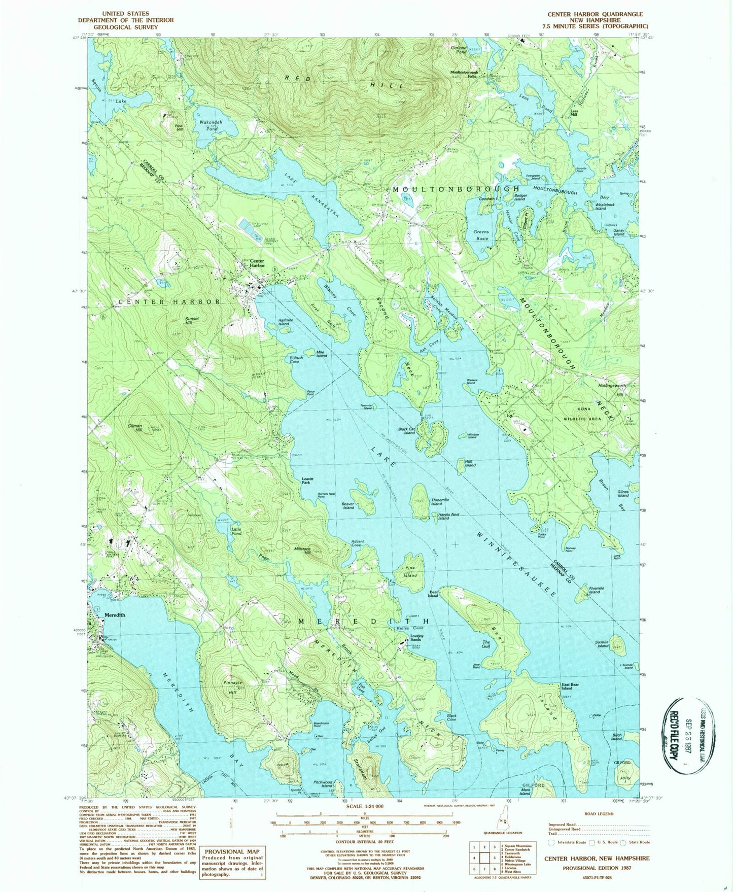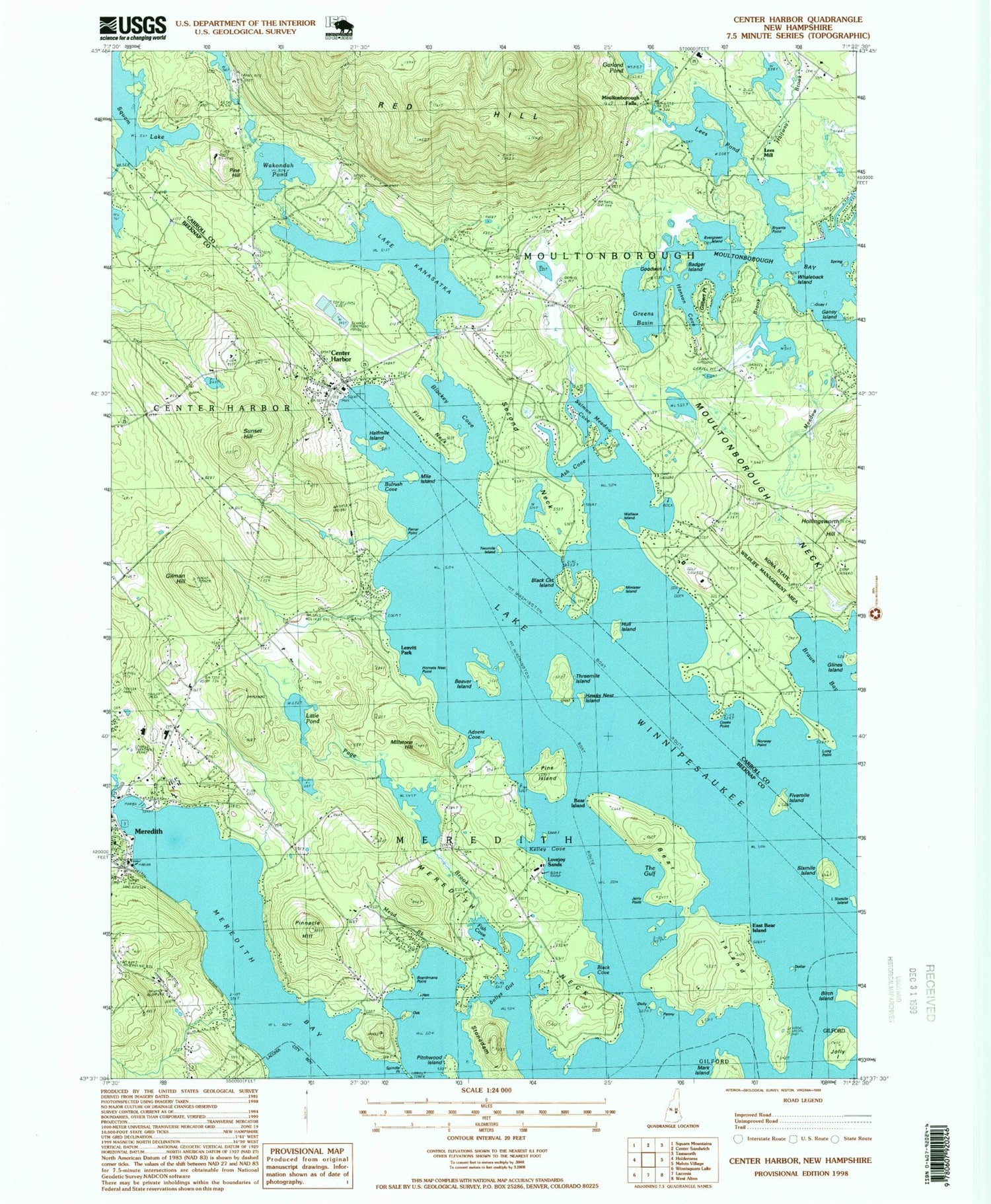

MyTopo
Classic USGS Center Harbor New Hampshire 7.5'x7.5' Topo Map
Couldn't load pickup availability
Historical USGS topographic quad map of Center Harbor in the state of New Hampshire. Typical map scale is 1:24,000, but may vary for certain years, if available. Print size: 24" x 27"
This quadrangle is in the following counties: Belknap, Carroll.
The map contains contour lines, roads, rivers, towns, and lakes. Printed on high-quality waterproof paper with UV fade-resistant inks, and shipped rolled.
Contains the following named places: Advent Cove, Alvord Wildlife Sanctuary, Ash Cove, Badger Island, Bean Cemetery, Bear Island, Bear Island, Beaver Island, Beckys Garden, Black Cat Island, Black Cove, Boardmans Point, Brown Cemetery, Bryants Point, Bulrush Cove, Center Harbor, Cooks Point, Dollar Island, East Bear Island, Evergreen Island, Farrar Point, Fish Cove, Fivemile Island, Gansy Island, Gilbert Point, Gillman Hill, Glines Island, Goodwin Island, Greens Basin, Gulay Island, Halfmile Island, Hanson Cove, Hawks Nest Island, Hen Island, Hollingsworth Hill, Hornets Nest Point, Horse Island, Hull Island, Jerry Point, Jolly Island, Lake Kanasatka, La Salette School, Leavitt Park, Lee Cemetery, Lees Pond, Little Pond, Little Sixmile Island, Long Point, Loon Island, Lovejoy Sands, Mead Brook, Meredith Bay, Meredith Neck, Mile Island, Millstone Hill, Minister Island, Moultonborough Falls, Norway Point, Oak Island, Page Brook, Penny Island, Pine Hill, Pine Island, Pinnacle Hill, Pitchwood Island, Red Hill, Red Hill Cemetery, Saint Johns Church, Sallys Gut, Salmon Meadow Cove, Second Neck, Shannon Brook, Sixmile Island, Spindle Point, Stonedam Island, Sunset Hill, The Gulf, Threemile Island, Twomile Island, Wakondah Pond, Wallace Island, Whaleback Island, Lees Mill, Halfway Brook, Red Hill River, WWSS-FM (Meredith), Town of Moultonborough, Lake Kanasatka Dam, Center Harbor Sewage Lagoon Dikes, Center Harbor Sewage Lagoons Reservoir, Aunt Dollys Point, The Beavers, Center Harbor Post Office, Center Harbor Town Beach, Centre Harbor Village Historic District, Dolly Island, Harbor Hill Camping Area, Immaculate Conception Apostolic Church, Inter - Lakes Elementary School, Inter - Lakes High School, Meredith Chamber of Commerce, Meredith Fire Station, Meredith Shopping Center, Proctor Preserve, Stonedam Narrows, Arcadia Tent and Trailer Park, Kona Wildlife Area, Red Hill Ski Touring Center, Round Island, Meredith Census Designated Place, Inter - Lakes Junior High School, Moultonborough Central School, Meredith Fire Department Main Station, Center Harbor Fire and Rescue, Center Harbor Police Department