MyTopo
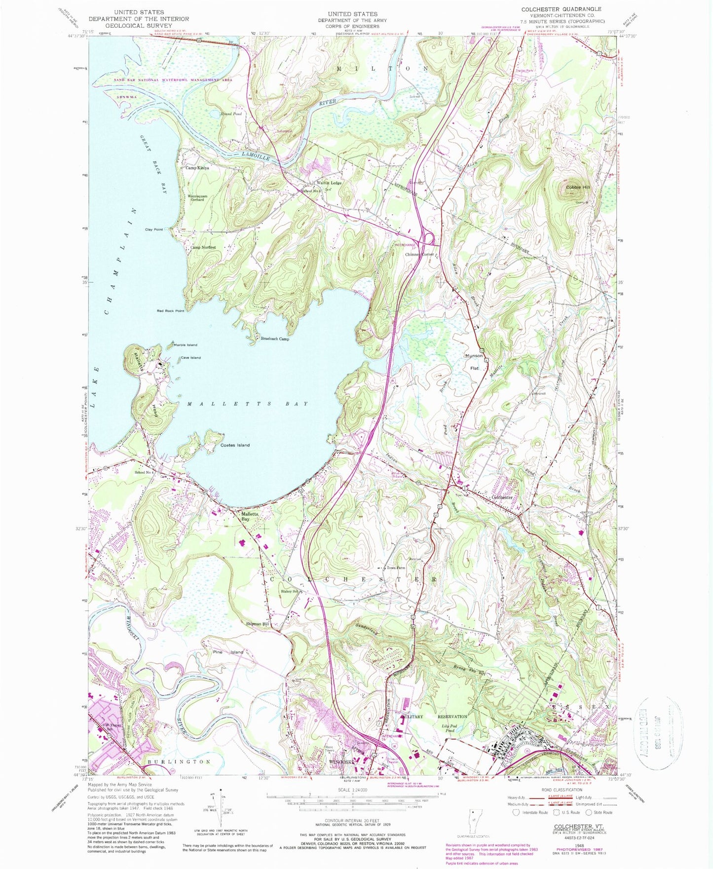
Classic USGS Colchester Vermont 7.5'x7.5' Topo Map
Couldn't load pickup availability
Historical USGS topographic quad map of Colchester in the state of Vermont. Map scale may vary for some years, but is generally around 1:24,000. Print size is approximately 24" x 27"
This quadrangle is in the following counties: Chittenden.
The map contains contour lines, roads, rivers, towns, and lakes. Printed on high-quality waterproof paper with UV fade-resistant inks, and shipped rolled.
Contains the following named places: Allen Brook, Blakey School, Brae Loch, Camp Johnson, Camp Kiniya, Camp Norfleet, Cave Island, Champlain Cemetery, Champlain Valley Baptist Church, Charles P Smith Elementary School, Chimney Corner, Clay Point, Coates Island, Cobble Hill, Colchester, Colchester Center Volunteer Fire Company, Colchester Center Volunteer Fire Company - Champlain Station, Colchester Center Volunteer Fire Company - Old Station, Colchester High School, Colchester Middle School, Colchester Police Department, Colchester Post Office, Colchester Rescue Station, Colchester Shopping Plaza Shopping Center, Ed-u-care Children's Center, Ethan Allen Homestead, Ethan Allen Park, Ethan Allen Shopping Center, Ethan Allen Tower, Fort Ethan Allen Military Reservation, Franciscan Sisters of Atonement Church, Great Back Bay, Harbor View Plaza Shopping Center, Indian Brook, Jakes Marina, John F Kennedy Elementary School, Lamoille River, Lily Pad Pond, Lone Pine Campsite, Lyman C Hunt Middle School, Mallets Bay State Park, Mallets Bay Yacht Club, Malletts Bay, Malletts Bay Campground, Malletts Bay Cemetery, Malletts Bay Congregational Church, Malletts Bay Elementary School, Malletts Bay Marina, Malletts Creek, Malletts Head, Malletts Head Seaplane Base, Marble Island, Marble Island Golf and Yacht Club, Mill Pond, Mill Pond Dam, Munson Cemetery, Munson Flat, North Avenue Alliance Church, North Avenue Christian School, North Avenue Shopping Center, North Burlington Post Office, Nourses Corner, Our Lady of Grace Church, Pine Island, Pond Brook, Ponnesoon Knolls Camp, Red Rock Point, Round Pond, Saint Mark Church, Saint Marks Family Center, Sand Bar National Waterfowl Management Area, School Number 3, School Number 4, Shipman Hill, South West Thayer School, Sunderland Brook, The Moorings, The Village Cemetery, Town Farm, Town of Colchester, Unification Church, Union Memorial Elementary School, United Church of Colchester, Walnut Ledge, Winnisquam Orchard, Winooski Junior / Senior High School, Winooski School District, Woodman Hall, WVMT-AM (Burlington), WXXX-FM (South Burlington), ZIP Codes: 05408, 05446