MyTopo
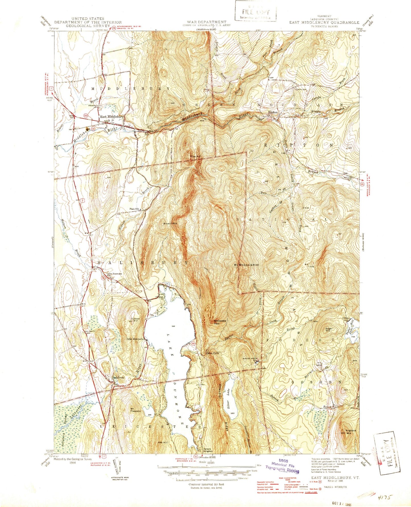
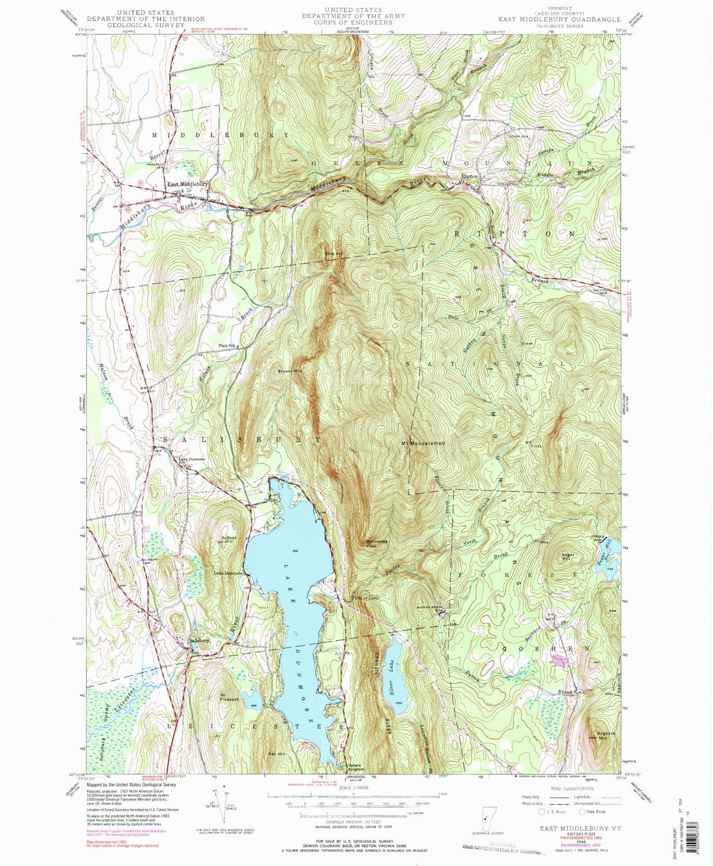
Classic USGS East Middlebury Vermont 7.5'x7.5' Topo Map
Couldn't load pickup availability
Historical USGS topographic quad map of East Middlebury in the state of Vermont. Typical map scale is 1:24,000, but may vary for certain years, if available. Print size: 24" x 27"
This quadrangle is in the following counties: Addison.
The map contains contour lines, roads, rivers, towns, and lakes. Printed on high-quality waterproof paper with UV fade-resistant inks, and shipped rolled.
Contains the following named places: Barnard Brook, Beaver Brook, Brandy Brook, Bryant Mountain, Chandler Ridge, Cooks Cemetery, Dragon Brook, Lake Dunmore, Dutton Brook, East Middlebury, Fire Brook, Galvin Cemetery, Gonya Brook, Goshen Brook, Goshen Dam, Hale Brook, Hogback Mountain, Keewaydin Trail, Lake Dunmore, Lake Dunmore School, Falls of Lana, Middle Branch Middlebury River, Mount Moosalamoo, North Branch Middlebury River, North Branch Sucker Brook, Oak Hill, Pine Hill, Plain School, Mount Pleasant, Prospect Cemetery, Rattlesnake Point, Ripton, Salisbury, Salisbury Cemetery, Satans Kingdom, Silver Lake, South Branch Middlebury River, Sparks Brook, Sucker Brook, Sucker Brook Dam, Sugar Hill, Sugar Hill Reservoir, Sunset Hill, Voters Brook, Gee Cemetery, Silver Towers Camp, Oak Ridge Trail, Robert Frost Wayside, Robert Frost Interpretive Trail, Moosalamoo Campground, Falls of Lana Picnic Grounds, North Branch Trail, Blueberry Hill Winter Sports Area, Branbury State Park, Silver Lake Camp and Picnic Grounds, Mount Moosalamoo Trail, Middlebury State Airport, Town of Salisbury, Stewart Dam, Sugar Hill Dam, Lake Dunmore Dam, Silver Lake Dam, Sucker Brook Reservoir, Camp Brebeuf for Boys, Camp Charidan, Camp Keewaydin, East Middlebury Post Office, Falls of Lana Trail, Gea Cemetery, Lake Dumore Kampersville, Mount Moosalamoo Campground Trail, Nabby Cooper Cemetery, Nature Trail, North Goshen Cemetery, Rice Cemetery, Riley Bostwick Wildlife Management Area, Ripton Elementary School, Robert Frost Wayside, Salisbury Community School, Salisbury Congregational Church, Salisbury Hatchery, Salisbury Municipal Forest, Sarah Partridge Library, Silver Lake Trail, Silver Lake Recreation Area, Silver Towers Camp, United States Forest Service Mount Moosalamoo Campground, United State Forest Service Silver Lake Campground, Valley Bible Church, Village Cemetery, Ripton Fire Department, Middlebury Volunteer Fire Department - Station 2, Salisbury Volunteer Department, East Middlebury Census Designated Place, Salisbury Post Office, Barnard Brook, Beaver Brook, Brandy Brook, Bryant Mountain, Chandler Ridge, Cooks Cemetery, Dragon Brook, Lake Dunmore, Dutton Brook, East Middlebury, Fire Brook, Galvin Cemetery, Gonya Brook, Goshen Brook, Goshen Dam, Hale Brook, Hogback Mountain, Keewaydin Trail, Lake Dunmore, Lake Dunmore School, Falls of Lana, Middle Branch Middlebury River, Mount Moosalamoo, North Branch Middlebury River, North Branch Sucker Brook, Oak Hill, Pine Hill, Plain School, Mount Pleasant, Prospect Cemetery, Rattlesnake Point, Ripton, Salisbury, Salisbury Cemetery, Satans Kingdom, Silver Lake, South Branch Middlebury River, Sparks Brook, Sucker Brook, Sucker Brook Dam, Sugar Hill, Sugar Hill Reservoir, Sunset Hill, Voters Brook, Gee Cemetery, Silver Towers Camp, Oak Ridge Trail, Robert Frost Wayside, Robert Frost Interpretive Trail, Moosalamoo Campground, Falls of Lana Picnic Grounds, North Branch Trail, Blueberry Hill Winter Sports Area, Branbury State Park, Silver Lake Camp and Picnic Grounds, Mount Moosalamoo Trail, Middlebury State Airport, Town of Salisbury, Stewart Dam, Sugar Hill Dam, Lake Dunmore Dam, Silver Lake Dam, Sucker Brook Reservoir, Camp Brebeuf for Boys, Camp Charidan, Camp Keewaydin, East Middlebury Post Office, Falls of Lana Trail, Gea Cemetery, Lake Dumore Kampersville, Mount Moosalamoo Campground Trail, Nabby Cooper Cemetery, Nature Trail, North Goshen Cemetery, Rice Cemetery, Riley Bostwick Wildlife Management Area, Ripton Elementary School, Robert Frost Wayside, Salisbury Community School, Salisbury Congregational Church, Salisbury Hatchery, Salisbury Municipal Forest, Sarah Partridge Library, Silver Lake Trail, Silver Lake Recreation Area, Silver Towers Camp, United States Forest Service Mount Moosalamoo Campground, United State Forest Service Silver Lake Campground, Valley Bible Church, Village Cemetery, Ripton Fire Department, Middlebury Volunteer Fire Department - Station 2, Salisbury Volunteer Department, East Middlebury Census Designated Place, Salisbury Post Office