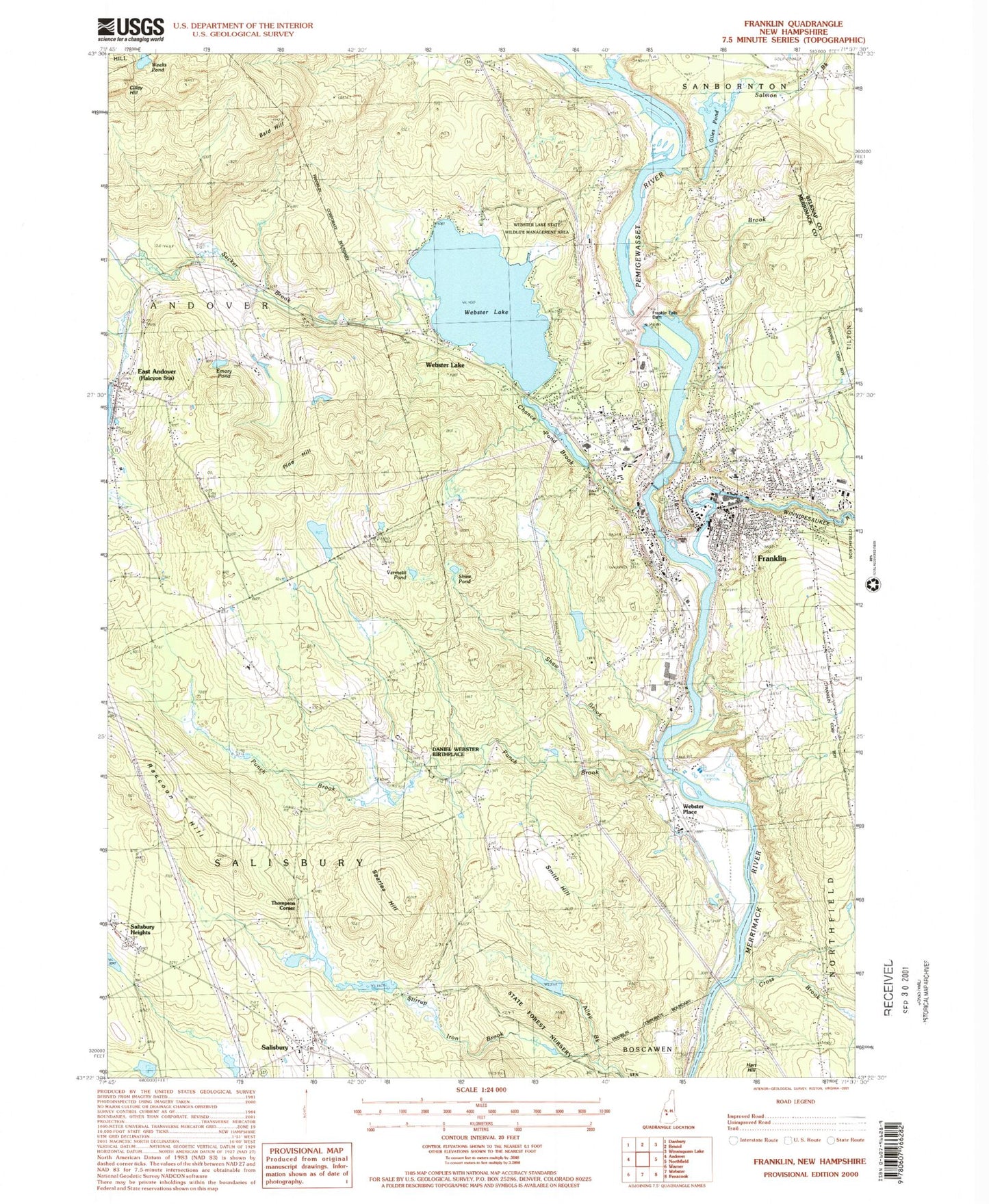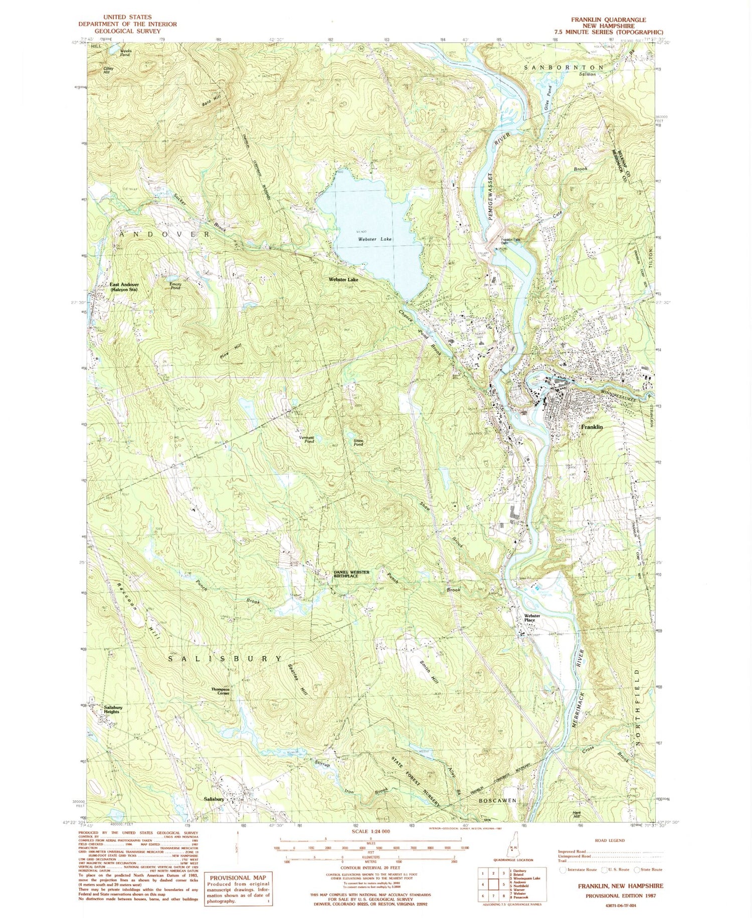
MyTopo
Classic USGS Franklin New Hampshire 7.5'x7.5' Topo Map
Couldn't load pickup availability
Historical USGS topographic quad map of Franklin in the state of New Hampshire. Typical map scale is 1:24,000, but may vary for certain years, if available. Print size: 24" x 27"
This quadrangle is in the following counties: Belknap, Merrimack.
The map contains contour lines, roads, rivers, towns, and lakes. Printed on high-quality waterproof paper with UV fade-resistant inks, and shipped rolled.
Contains the following named places: Allen Brook, Bald Hill, Bog Road Cemetery, Cate Brook, Chance Pond Branch, Cilley Hill, Cross Brook, Daniel Webster Birthplace, Daniel Webster Home for Children, East Andover, Emory Pond, Franklin Falls Dam, Giles Pond, Holy Cross Cemetery, Maplewood Cemetery, Oak Hill Cemetery, Pine Hill, Punch Brook, Salisbury, Salisbury Heights, Salmon Brook, Searles Hill, Shaw Brook, Shaw Corner Cemetery, Shaw Pond, Smith Hill, South Road School, Sucker Brook, Threshing Mill Brook, Vermetti Pond, Webster Lake, Webster Lake, Webster Place, Weeks Brook, Weeks Pond, Winnipesaukee River, Thompson Corner, Pemigewasset River, Mojalaki Golf Course, Franklin, D W Heliport, Ward Field, WFTN-AM (Franklin), City of Franklin, Franklin Falls Dam, Highland Lake Dam, Eastman Falls Dam, Pemigewasset River Reservoir, Giles Pond Dam, Giles Pond, Webster Lake Dam, Webster Lake and Chance Pond, New Pond Dam, New Pond, Sulloway Mills Dam, Winnepesaukee River Reservoir, Andover Congregational Church, Archie Grevior Medical Library, Baptist Church of Franklin, Bessie C Rowell School, Central Baptist Church, The Church of Jesus Christ of Latter Day Saints, Daniel Webster Bridge, East Andover Post Office, Franklin Chamber of Commerce, Franklin City Hall, Franklin Falls Historic District, Franklin High School, Franklin Middle School, Franklin Post Office, Franklin Public Library, Franklin Regional Hospital, Odell Park, Old Baptist Church, Paul A Smith School, Saint Judes Episcopal Church, Saint Marys School, Saint Pauls Church, Salisbury Academy, Salisbury Community Church, Salisbury Elementary School, Salisbury Post Office, Shaw Corner (historical), Shaw Corner Cemetery, Sulphite Bridge, Taylor House for Boys, Unitarian Church of Franklin, West Franklin, Salisbury Free Library, Gile Pond Airport, Serendipity School, Franklin Career Charter Academy, Montessori House of Children School, Franklin Fire Department, Salisbury Volunteer Fire Department, East Andover Fire Department, Sanbornton Fire Department, Twin Rivers Ambulance Transfer Services, Andover Rescue Squad, Tucker Farm Airport, Franklin Police Department, Salisbury Police Department, Franklin Cemetery