MyTopo
Classic USGS Georgetown Massachusetts 7.5'x7.5' Topo Map
Couldn't load pickup availability
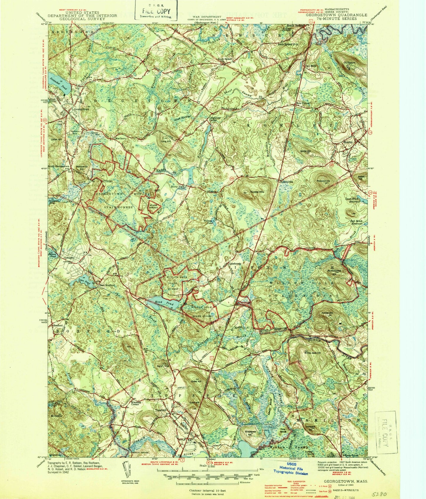
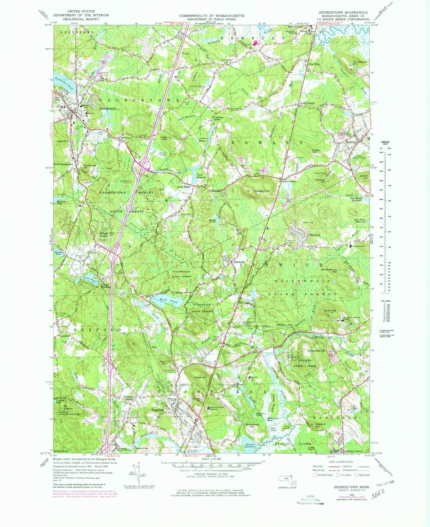
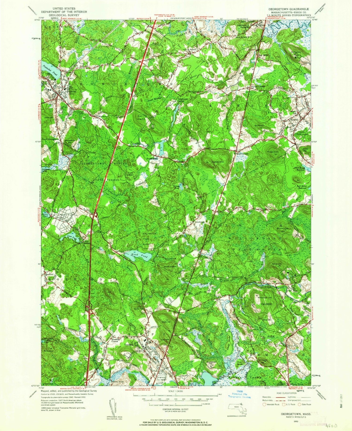
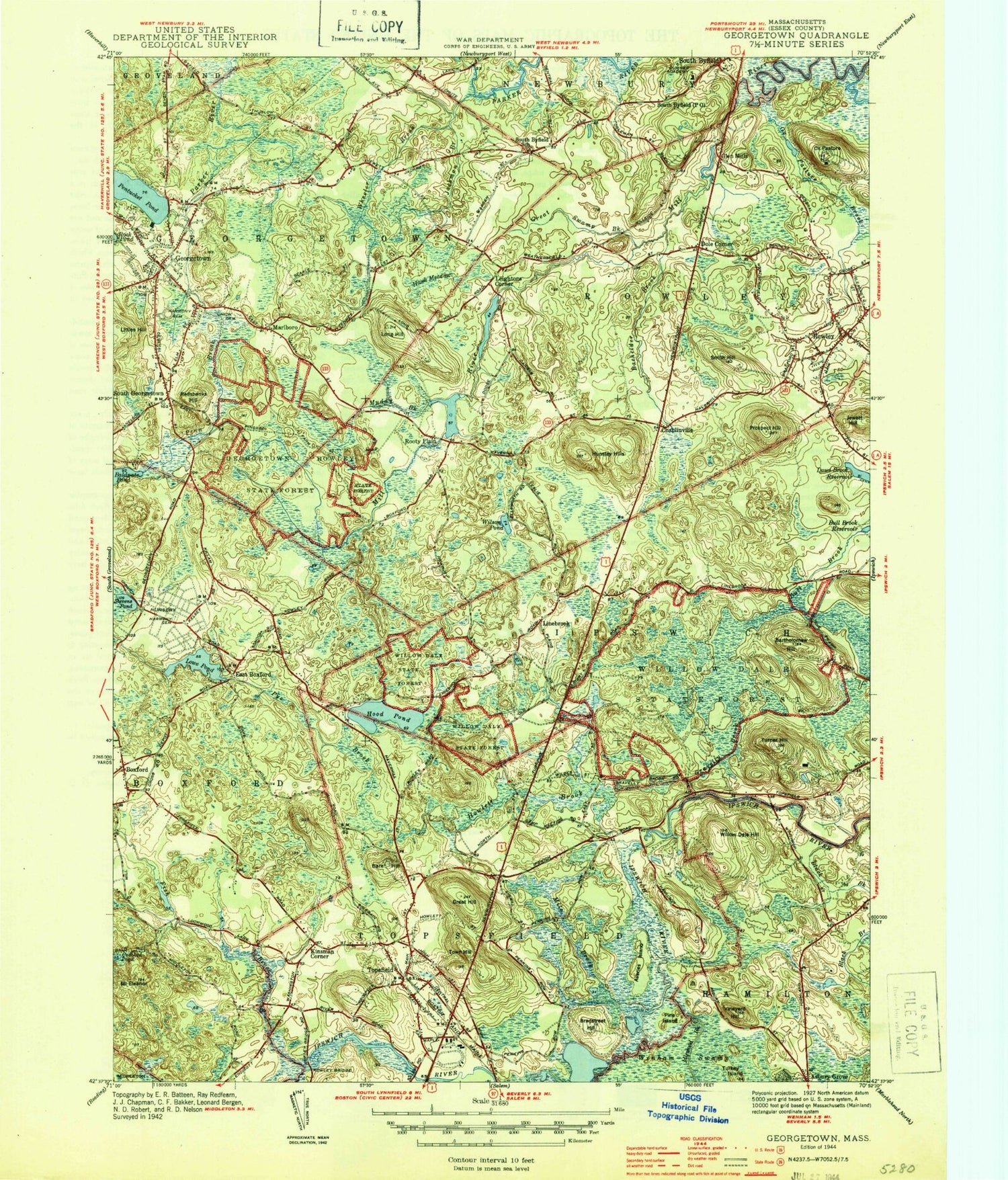
Historical USGS topographic quad map of Georgetown in the state of Massachusetts. Typical map scale is 1:24,000, but may vary for certain years, if available. Print size: 24" x 27"
This quadrangle is in the following counties: Essex.
The map contains contour lines, roads, rivers, towns, and lakes. Printed on high-quality waterproof paper with UV fade-resistant inks, and shipped rolled.
Contains the following named places: Perley Elementary School, Georgetown High School, South Byfield Church, Adelynrood Retreat, Rogers School, Rowley Burial Ground, Pingree School, Our Lady of LaSalette Seminary, New Meadows Golf Club, Rowley Bridge, Village Cemetery, Masconomet Regional High School, Linebrook School, Willowdale State Forest, Harmony Cemetery, Georgetown Rowley State Forest, Harmony Cemetery, Union Cemetery, Mile Brook Reservoir, Mile Brook Dam, Fish Brook Reservoir, Fish Brook Dam, Howes Pond Dam, Ipswich River Reservoir, Ipswich River Dam, Hood Pond Dam, Lowe Pond Outlet Dam, Fourmile Pond Dam, Baldpate Pond Dam, Upper Millpond Dam, Lower Millpond Dam, Pentucket Pond Outlet Dam, Pentucket Pond Outlet Reservoir, Parker River Reservoir, Ornes Hill, Little Turners Hill, Pine Grove Cemetery, Maryknoll Sisters Novitiate, Proctor Elementary School, Steward Elementary School, Blueberry Hill, B W Palmer State Park, Boxford Station (historical), Topsfield Station, Crooked Pond, Averills Island, Bachelder Brook, Bare Hill, Bartholomew Hill, Bear Hill, Black Brook, Boxford, Bradstreet Hill, Bunker Meadows, Doles Corner, East Boxford, Mound Eleanor, Fish Brook, Georgetown, Glen Mills, Gravelly Brook, Great Hill, Great Swamp Brook, Hawk Meadow, Hood Pond, Howlett Brook, Hunsley Hills, Idlewild Brook, Jackman Brook, Kent Corner, Kings Forest, Kinsman Corner, Leightons Corner, Linebrook, Long Hill, Long Hill, Lowe Pond, Lower Millpond, Marlboro, Mile Brook, Muddy Brook, Ox Pasture Brook, Ox Pasture Hill, Penn Brook, Pinefield, Pine Island, Prospect Hill, Pye Brook, Redshanks Hill, Rockery Pond, Rooty Plain, Rowley, Smith Hill, South Byfield, South Georgetown, Stevens Pond, Teal Pond, Topsfield, Town Hill, Turkey Island, Turner Hill, Upper Millpond, Vineyard Hill, Pintail Pond, Wheeler Brook, Moon Hill, Wilson Pond, Town of Rowley, Town of Topsfield, Rowley Post Office (historical), Georgetown Post Office (historical), Boxford Post Office (historical), WBMT-FM (Boxford), Bentley Heliport, Town of Georgetown, Boxford Post Office, American League Park, Boxford Village Historic District, Brock Historical House, Central School, First Baptist Church, First Congregational Church, First Congregational Church, First Congregational Church, Free Public Library, Georgetown Middle-High School, Georgetown Peabody Library, Georgetown Post Office, Georgetown Shopping Center, Georgetown Town Office, Ipswich Wildlife Sanctuary, Byfield Parish Church, Masconomet Regional Middle School Library, Paul F Doyon Memorial School, Penn Brook School, Pingree School Library, Doyon Memorial School Library, Georgetown Middle High School Library, Solstice School, Topsfield Town Library, Triton Middle School, Triton Regional High School Library, Boxford Census Designated Place, Topsfield Census Designated Place, Topsfield Fire Department, Boxford Fire Department East Station, Georgetown Fire Department Headquarters, Rowley Fire Department, Georgetown Fire Department Erie 4 Station, Ipswich Fire Department Station 2, Rowley Town Police Department, Topsfield Police Department, Georgetown Police Department, Rowley Post Office, Topsfield Post Office, Hood Pond, Perley Elementary School, Georgetown High School, South Byfield Church, Adelynrood Retreat, Rogers School, Rowley Burial Ground, Pingree School, Our Lady of LaSalette Seminary, New Meadows Golf Club, Rowley Bridge, Village Cemetery, Masconomet Regional High School, Linebrook School, Willowdale State Forest, Harmony Cemetery, Georgetown Rowley State Forest, Harmony Cemetery, Union Cemetery, Mile Brook Reservoir, Mile Brook Dam, Fish Brook Reservoir, Fish Brook Dam, Howes Pond Dam, Ipswich River Reservoir, Ipswich River Dam, Hood Pond Dam, Lowe Pond Outlet Dam, Fourmile Pond Dam, Baldpate Pond Dam, Upper Millpond Dam, Lower Millpond Dam, Pentucket Pond Outlet Dam, Pentucket Pond Outlet Reservoir, Parker River Reservoir, Ornes Hill, Little Turners Hill, Pine Grove Cemetery, Maryknoll Sisters Novitiate, Proctor Elementary School, Steward Elementary School, Blueberry Hill, B W Palmer State Park, Boxford Station (historical), Topsfield Station, Crooked Pond, Averills Island, Bachelder Brook, Bare Hill, Bartholomew Hill, Bear Hill, Black Brook, Boxford, Bradstreet Hill, Bunker Meadows, Doles Corner, East Boxford, Mound Eleanor, Fish Brook, Georgetown, Glen Mills, Gravelly Brook, Great Hill, Great Swamp Brook, Hawk Meadow, Hood Pond, Howlett Brook, Hunsley Hills, Idlewild Brook, Jackman Brook, Kent Corner, Kings Forest, Kinsman Corner, Leightons Corner, Linebrook, Long Hill, Long Hill, Lowe Pond, Lower Millpond, Marlboro, Mile Brook