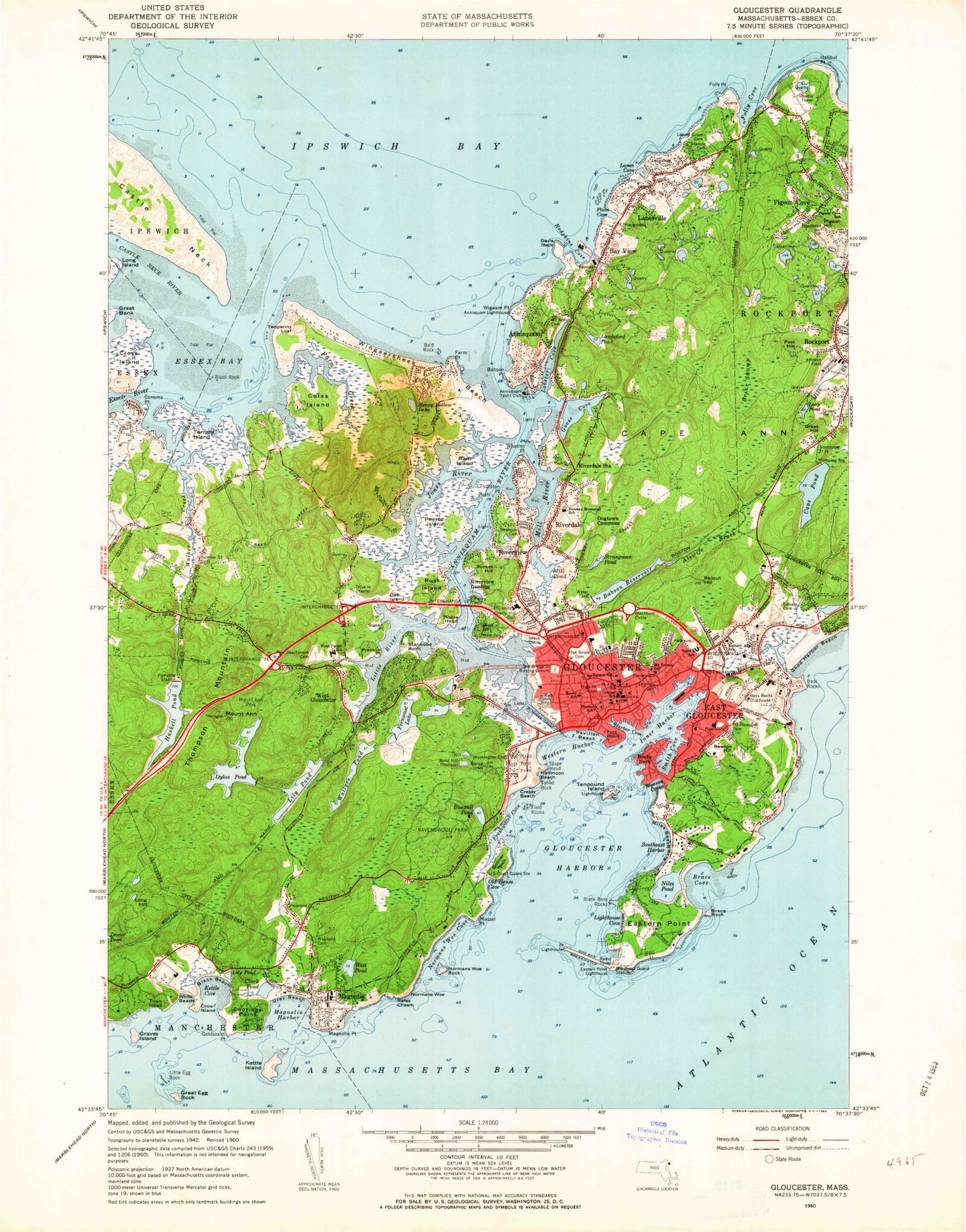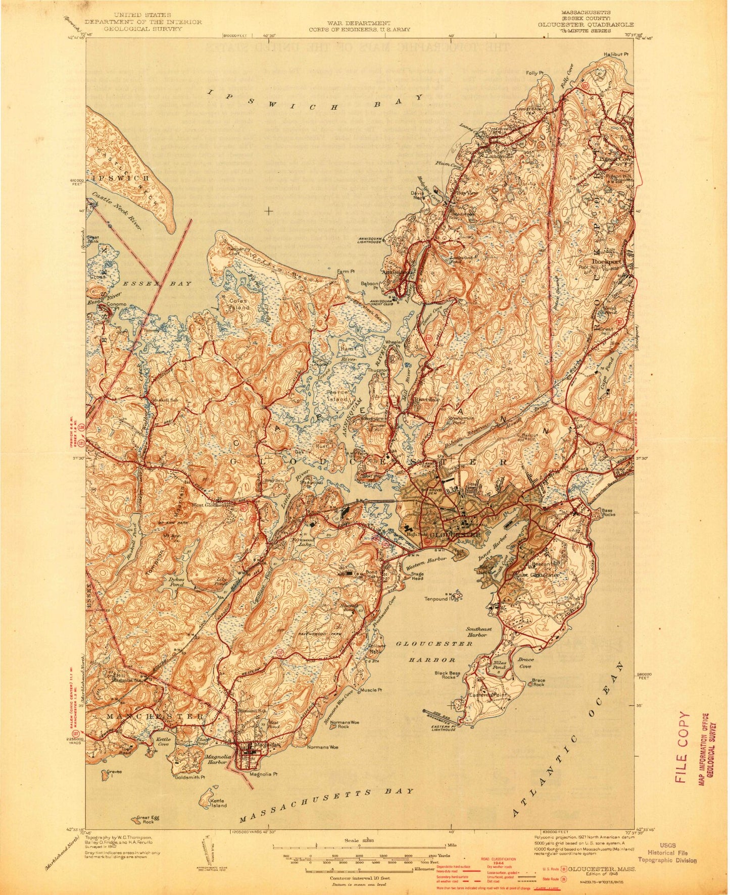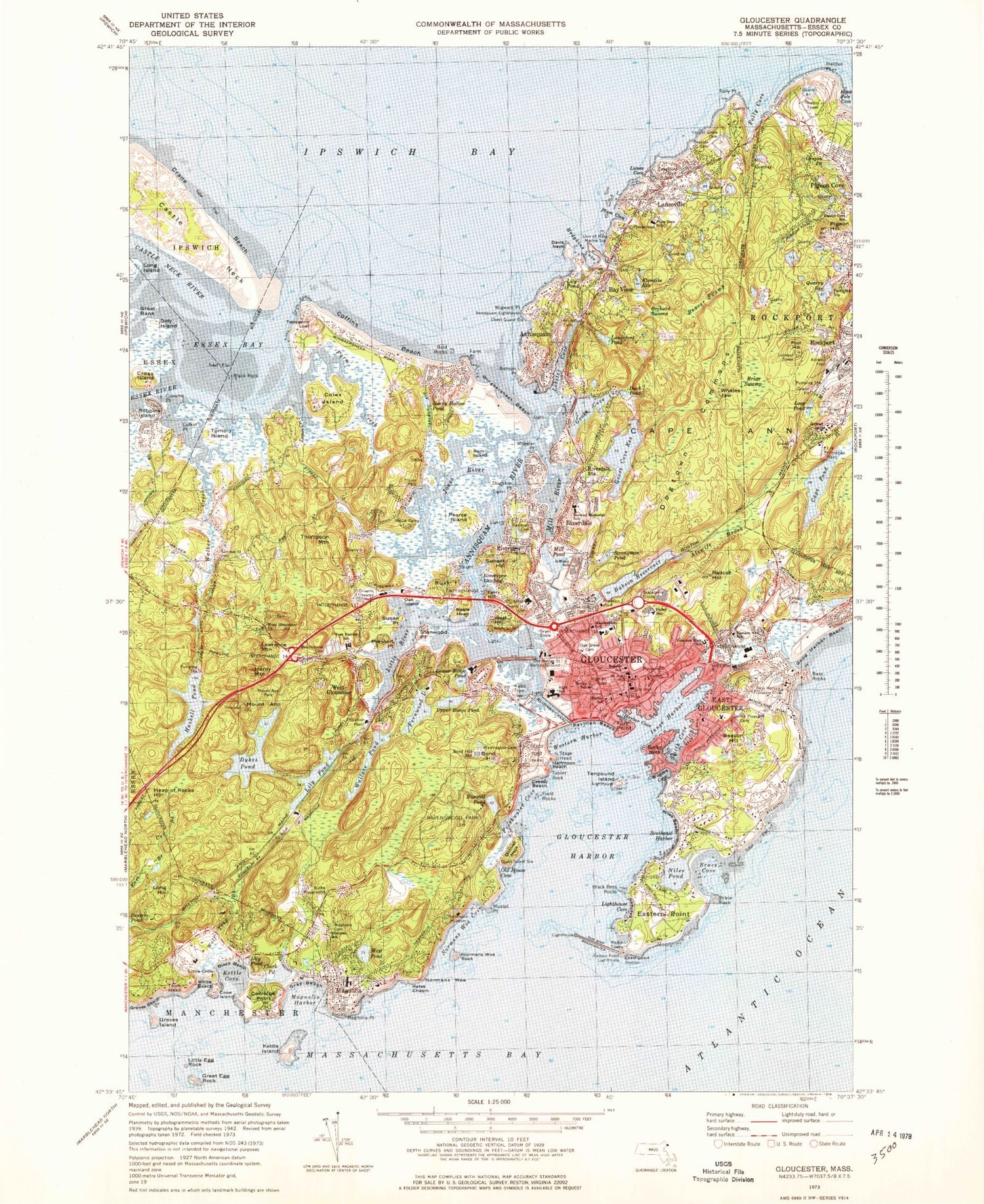

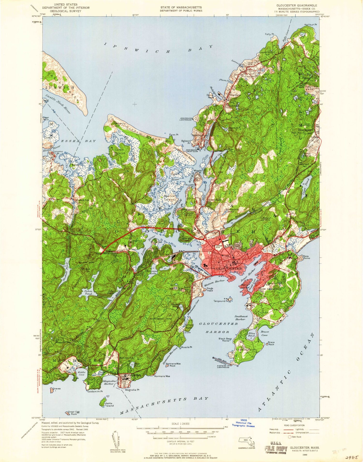
MyTopo
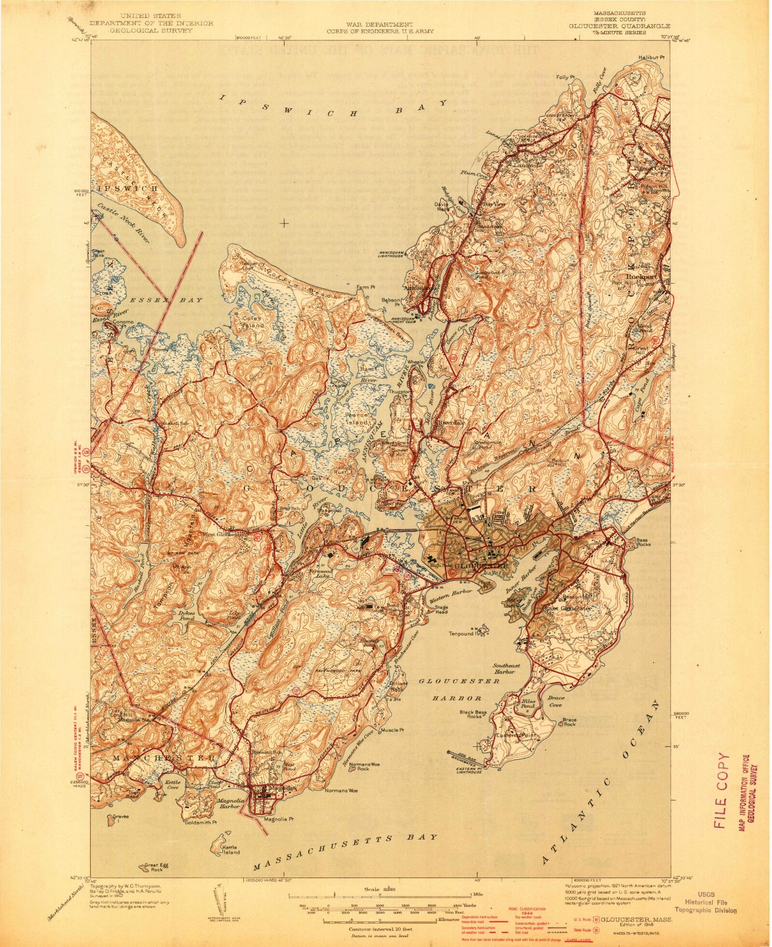
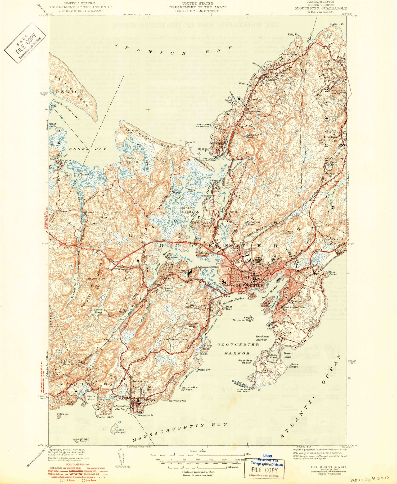
Classic USGS Gloucester Massachusetts 7.5'x7.5' Topo Map
Couldn't load pickup availability
Historical USGS topographic quad map of Gloucester in the state of Massachusetts. Typical map scale is 1:24,000, but may vary for certain years, if available. Print size: 24" x 27"
This quadrangle is in the following counties: Essex.
The map contains contour lines, roads, rivers, towns, and lakes. Printed on high-quality waterproof paper with UV fade-resistant inks, and shipped rolled.
Contains the following named places: Dog Bar, Pancake Ground, Eastern Point Light, Gloucester Breakwater Light, Tenpound Island Light, Beechbrook Cemetery, Mount Ann Park, Washington Cemetery, Magnolia Cemetery, Blynman School, West Gloucester Church, Mount Pleasant Cemetery, Eastern Avenue School, Veterans Memorial School, Babson School, Gloucester High School, West Gloucester Station, Gloucester Station, Little River Marshes, Dolliver Beach Neck Marshes, Good Harbor Beach Marshes, Burke Playground, Hammond Museum, First Parish Burial Ground, Cherry Hill Cemetery, Oak Hill Cemetery, Maplewood School, Oak Grove Cemetery, Gloucester City Hall, Bass Rocks Country Club, Ravenswood Park, Tenpound Island Lighthouse, State Fort Park, Eastern Point Lighthouse, West Pond Outlet Dam, Buswell Pond Dam, Dykes Dam, Lily Pond Outlet Dam, Fernwood Lake West Dam, Wallace Pond Outlet Dam, Upper Banjo Pond Dam, Fernwood Lake East Dam, Fernwood Lake Dam, Haskell Pond Dam, Beauport Museum, Rocky Neck Art Colony, North Shore Art Association, Fitz Hugh Lane House, Cape Ann Chamber of Commerce, Sargent-Murray-Gilmon-Hough House, Gloucester Fishermens Museum, Fishermens Monument, Little Good Harbor, Dog Bar Channel, West Parish Elementary School, Saint Ann Elementary School, Prospect Street Cemetery, Hovey School, Forbes School, Middle Ground, Burnham Rocks, Saturday Night Ledge, Kettle Island Ledge, South Channel, Milton L Fuller Elementary School, Oakes Cove, Dexter Pond, Mount Ann, Babson Ledge, Bass Rocks, Bass Rocks, Beacon Hill, Bemo Ledge, Black Beach, Black Bess Point, Black Bess Rocks, Black Rock, Bond Hill, Boohoo Ledge, Brace Rock, Buck Rock, Buswell Pond, Clark Pond, Coolidge Point, Cove Ledge, Cressy Beach, Crow Island, Crow Island Rock, David Rock, Dolliver Neck, Dykes Pond, Eastern Point, Eastern Point Ledge, East Gloucester, Fernwood Lake, Field Rocks, Fort Point, Freshwater Cove Village, Gloucester, Gloucester Harbor, Goldsmith Point, Good Harbor Beach, Graves Beach, Graves Island, Gray Beach, Great Egg Rock, Green Rock, Halfmoon Beach, Harbor Ledge, Haskell Pond, Inner Harbor, Kettle Cove Village, Kettle Island, Kitfield Ledge, Lily Pond, Little Egg Rock, Little River, Long Hill, Magnolia, Magnolia Point, Mayflower Ledge, Mill Ledge, Mussel Point, Neverfail Ledge, Niles Beach, Niles Pond, Old Spirit Rock, Pavilion Beach, Popplestone Beach, Popplestone Ledge, Prairie Ledge, Presson Point, Rafes Chasm, Ragged Ledge, Rocky Neck, Rocky Neck, Round Rock Shoal, Saddle Rock, Southeast Harbor, Stage Head, Stanwood Point, Stone Ledge, Susan Point, Tablet Rock, Tenpound Island, Tenpound Island Ledge, Town Head, Wallace Pond, Webber Rock, West Pond, West Gloucester, White Beach, Wolf Hill, Biskie Head, Normans Woe, Normans Woe Rock, Normans Woe Cove, Blynman Canal, Dog Bar Breakwater, Burnham Rocks, Cole Ridge, Kettle Island Ledge, Paddock Rock, Saturday Night Ledge, Naushon Point Shoal, Five Pound Island, Wolf Trap Branch, Upper Banjo Pond, The Cut (historical), Brace Cove, Freshwater Cove, Harbor Cove, Kettle Cove, Lighthouse Cove, Old House Cove, Smith Cove, Western Harbor, Wonson Cove, West Gloucester Post Office (historical), WBOQ-FM (Gloucester), USCG Heliport, Sadler Hill Heliport, Magnolia Harbor, Lower Banjo Pond, Assembly of God Church, Beauport, Blynman Drawbridge, Cape Ann Historical Association, Cape Ann Historical Association Library, Cape Ann Historical Museum, Cape Ann Industrial Park, Captain Solomon Jacobs Park, Central Gloucester Historic District, East Gloucester Elementary School, East Gloucester Shopping Center, First Church of Christ Scientist, Gloucester Alternative High School, Gloucester Community Church, Gloucester Fisherman Statue, Gloucester Lyceum, Gloucester Post Office (historical), Hidden Park, Kettle Cove Industrial Park, Saint Johns Episcopal Church, Heap of Rocks Hill, Gloucester High School Library, Saint Mel Day School, Gloucester Fire Department Headquarters, Gloucester Fire Department West Gloucester Station, Gloucester Fire Department Magnolia Station, Gloucester Police Department, Gloucester Post Office, Magnolia Post Office, Dog Bar, Pancake Ground, Eastern Point Light, Gloucester Breakwater Light, Tenpound Island Light, Beechbrook Cemetery, Mount Ann Park, Washington Cemetery, Magnolia Cemetery, Blynman School, West Gloucester Church, Mount Pleasant Cemetery, Eastern Avenue School, Veterans Memorial School, Babson School, Gloucester High School, West Gloucester Station, Gloucester Station, Little River Marshes, Dolliver Beach Neck Marshes, Good Harbor Beach Marshes, Burke Playground, Hammond Museum