MyTopo
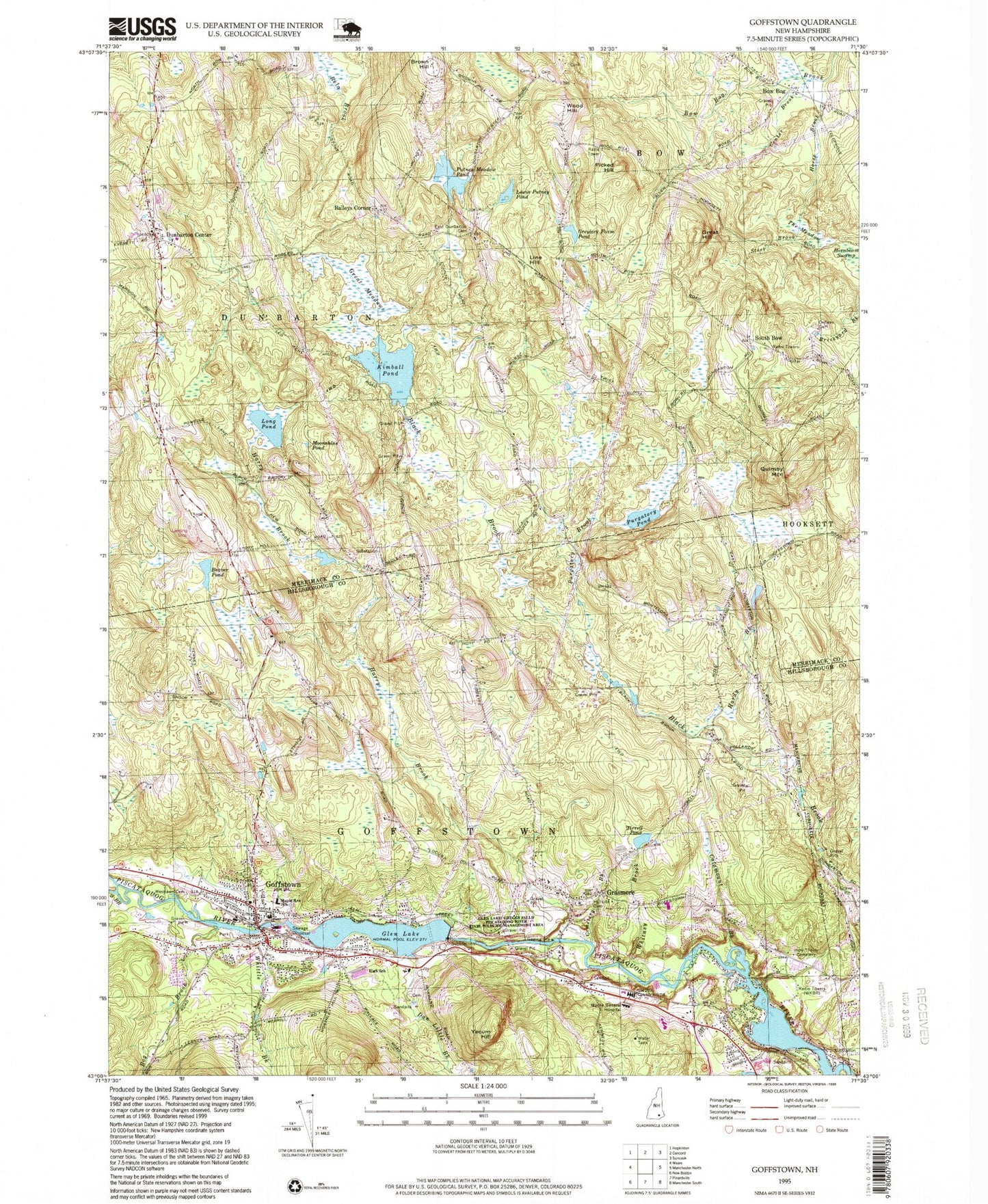
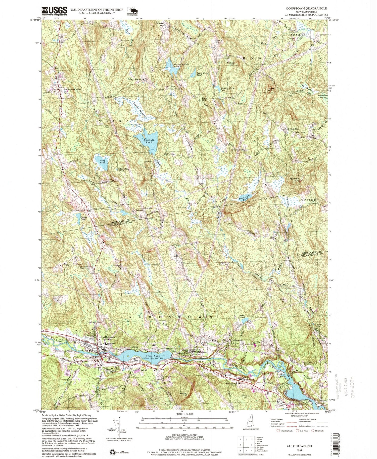
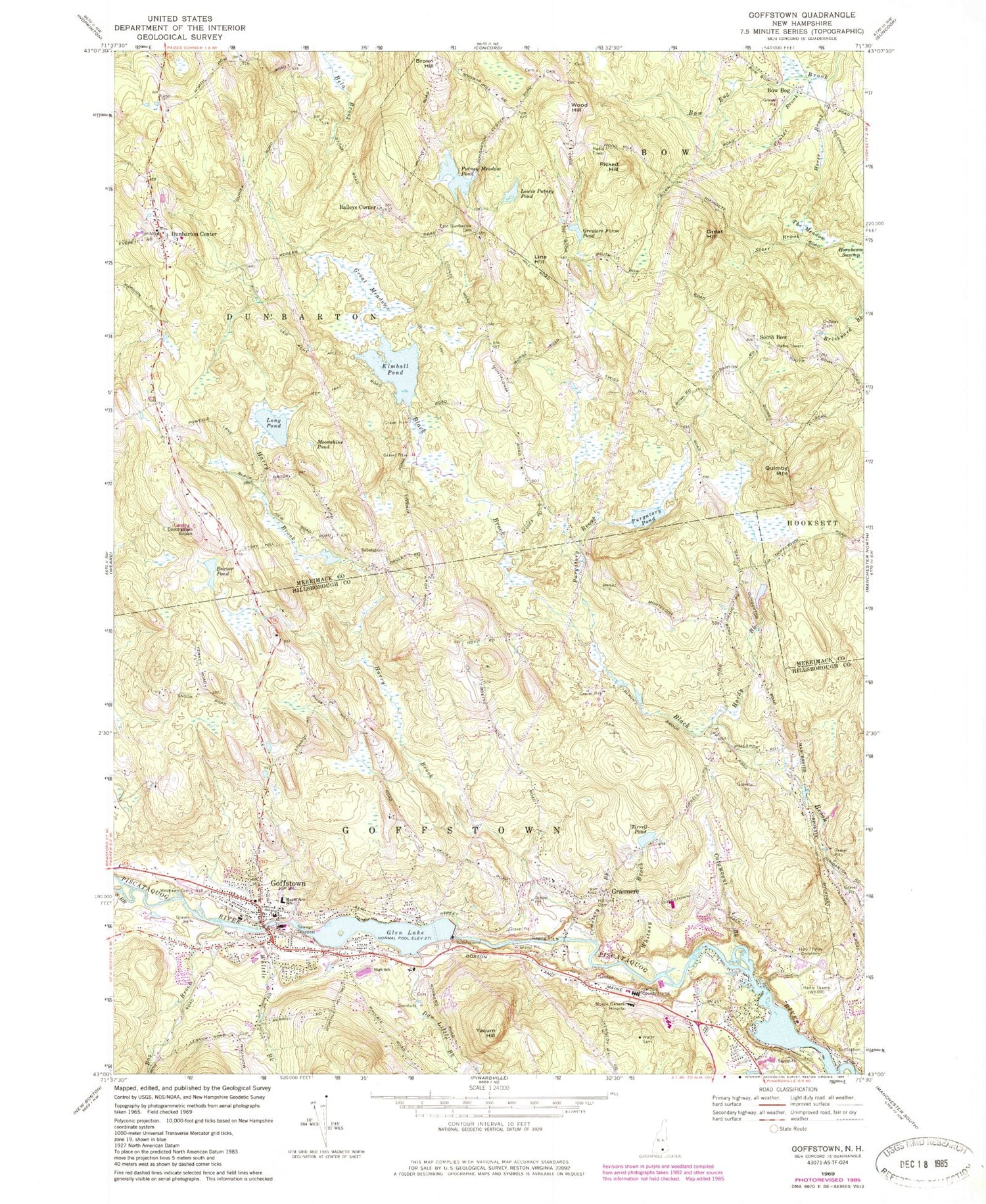
Classic USGS Goffstown New Hampshire 7.5'x7.5' Topo Map
Couldn't load pickup availability
Historical USGS topographic quad map of Goffstown in the state of New Hampshire. Typical map scale is 1:24,000, but may vary for certain years, if available. Print size: 24" x 27"
This quadrangle is in the following counties: Hillsborough, Merrimack.
The map contains contour lines, roads, rivers, towns, and lakes. Printed on high-quality waterproof paper with UV fade-resistant inks, and shipped rolled.
Contains the following named places: Horse Brook, Beaver Pond, Bog Brook, Bow Bog, Brown Hill, Catamount Brook, Cemetery Brook, Center Brook, Dan Little Brook, Dunbarton Center, East Dunbarton Cemetery, Glen Lake, Goffstown, Grasmere, Great Hill, Great Meadows, Greylore Farm Pond, Hardy Brook, Harry Brook, Hillside Cemetery, Holy Trinity Cemetery, Hornbeam Swamp, Kimball Pond, Lewis Putney Pond, Line Hill, Long Pond, Maple Avenue Elementary School, Moonshine Pond, Moore General Hospital, Ordway Cemetery, Picked Hill, Purgatory Brook, Purgatory Pond, Putney Meadow Pond, Quimby Mountain, South Branch Piscataquog River, The Meadow, Tirrell Pond, Westlawn Cemetery, Whitney Brook, Whittle Brook, Wood Hill, Yacum Hill, Baileys Corner, South Bow, Goffstown Country Club, Audley Divide Heliport, Sterling Place Heliport, Country Club Air Park, WKBR-AM (Manchester), Town of Dunbarton, Town of Goffstown, Us Bobbin and Shuttle Company Dam, Piscataquog River Reservoir, Greggs Falls Dam, Kimball Pond Dam, Putney Meadow Pond Dam, Goffstown High School, Goffstown Christian Fellowship, Goffstown Christian School, Goffstown Congregational Church, Goffstown Covered Railroad Bridge, Goffstown Plaza Shopping Center, Goffstown Post Office, Goffstown Town Hall, Grasmere Junction (historical), Grasmere Station (historical), Grasmere Schoolhouse Number 9 (historical), Grasmere Town Hall, Greggs Falls, Hillsborough County Farm, Hillside United Methodist Church, Mountain View Middle School, Page Hill School (historical), Pattee School (historical), Saint Lawrence Church, Saint Matthews Episcopal Church, Shirley Park, Tibbitts Hill School (historical), Villa Augustina School, Bow Bog School (historical), Brown Hill Cemetery, Burnham School (historical), Dunbarton Elementary School, Goffstown Country Club, Goodhue Cemetery, Green Cemetery, Hammond Cemetery, School Number 1 (historical), South Bow School (historical), Waite School (historical), First Congregational Church, Pinardville Census Designated Place, Goffstown Fire Department East Goffstown Station / Station 17, Dunbarton Police Department, Goffstown Fire Department Village Station / Station 18, Goffstown Census Designated Place, Goffstown Police Department, Hillsborough County Sheriff's Office, Dunbarton Police Department, Dunbarton Center Cemetery