MyTopo
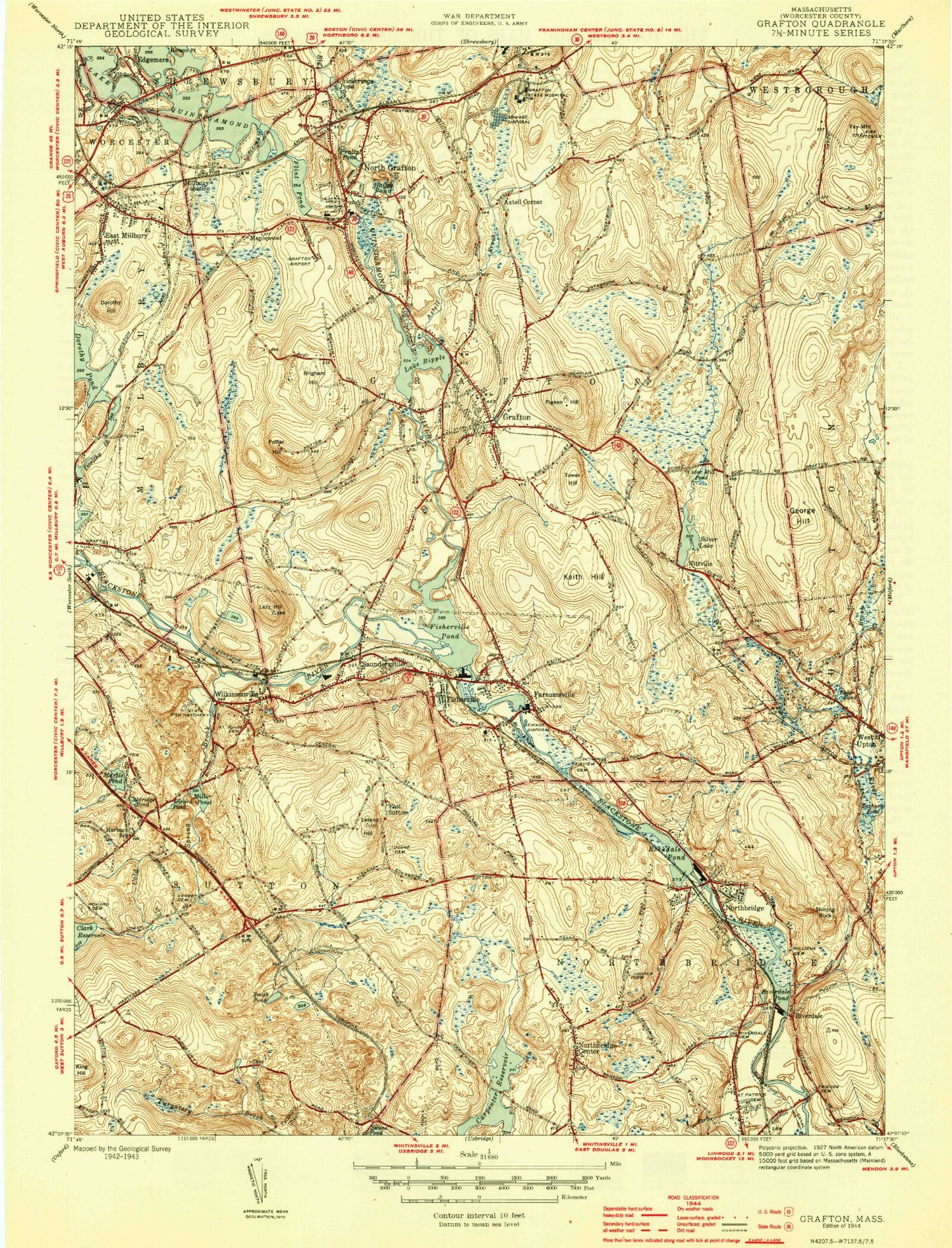
Classic USGS Grafton Massachusetts 7.5'x7.5' Topo Map
Couldn't load pickup availability
Historical USGS topographic quad map of Grafton in the state of Massachusetts. Typical map scale is 1:24,000, but may vary for certain years, if available. Print size: 24" x 27"
This quadrangle is in the following counties: Worcester.
The map contains contour lines, roads, rivers, towns, and lakes. Printed on high-quality waterproof paper with UV fade-resistant inks, and shipped rolled.
Contains the following named places: Saint Johns Cemetery, Friends Cemetery, Grafton Middle School, Fisherville School, Riverside Cemetery, Saint Philip's Catholic Cemetery, Friends Cemetery, Saint Patricks Cemetery, Harding Street School, Dodge Cemetery, Sutton State Forest, Purgatory Chasm State Park, Riverdale Cemetery, Fairview Cemetery, Upton State Forest, Grafton State Hospital, Grafton Memorial Senior High School, Grafton Intermediate School, Pine Grove Cemetery, Armsby Cemetery, Howard Cemetery, Saint Vincent Hospital, Granite Street School, Carpenter Reservoir Dike, Carpenter Reservoir Dam, Blackstone River Reservoir, Riverdale Dam, Clark Reservoir Dam, Woodbury Pond Dam, Marble Pond Dam, West River Reservoir, Wildwood Lake Dam, Farnumsville Pond Dam, Fisherville Pond Dam, Blackstone River Dam, Chase Road Dam, Silver Lake Dam, Lake Ripple Dam 47, Dorothy Pond Dam, Hovey Dam, Pratts Pond Dam, Lower Westboro Reservoir Dam, Lower Westboro Reservoir, Lake Quigsigamond Dam, Clark Reservoir, Dorothy Pond, Woolshop Pond, Aldrich Pond, Axtell Brook, Axtell Corner, Baker Pond, Big Bummet Brook, Brigham Hill, Carpenter Reservoir, Cider Millpond, Cogan Pond, Cold Spring Brook, Cronin Brook, Dorothy Hill, East Millbury, East Sutton, Edgemere, Farnumsville, Fay Mountain, Fisherville, Fisherville Pond, Flint Pond, George Hill, Girard Pond, Grafton, Hayes Pond, Hovey Pond, Keith Hill, King Hill, Kittville, Lazy Hill, Leland Hill, Maplewood, Marble Pond, Millbury Junction, Miscoe Brook, Nelson Point, Norcross Point, Northbridge, Northbridge Center, North Grafton, Oak Island, Pigeon Hill, Point Rok Beach, Potter Hill, Pratts Pond, Purgatory Chasm, Quinsigamond River, Lake Ripple, Riverdale, Riverdale Pond, Rockdale Pond, Saundersville, Shining Rock, Silver Lake, Smith Pond, Warren Brook, Wilkinsonville, Windle Pond, Woodbury Pond, Zachary Pond, Tower Hill, Town of Northbridge, Waters Airport, Blackstone Canal, Town of Grafton, John H Chafee Blackstone River Valley National Heritage Corridor, Baptist Church of Grafton, Cooper Road Cemetery, Grafton Post Office, North Grafton Elementary School, North Grafton Post Office, North Grafton United Methodist Church, Northbridge Centre Congregational Church, Northbridge Post Office, Old Oak Street Burial Ground, Rockdale Common Housing District, Rockdale Congregational Church, Saint Andrews Episcopal Church, Saint James Parish Center, Saint Marys Church, Saint Peters Parish Center, Saint Phillips Church, South Grafton Elementary School, South Grafton Post Office, Union Congregational Church, Willard House and Clock Museum, Grafton Station, Webster Veterinary Medical Library, Hassanamisco Reservation, Keown Orchard, Grafton Fire Department, Shrewsbury Fire Department, Millbury Fire Department Station 3, Sutton Fire Department Station 3, Grafton Police Department, Northbridge Police Department, Sutton Post Office, Old Farnumsville Cemetery, Friendly Hassanamiscos Burial Ground, Indian Burying Ground