MyTopo
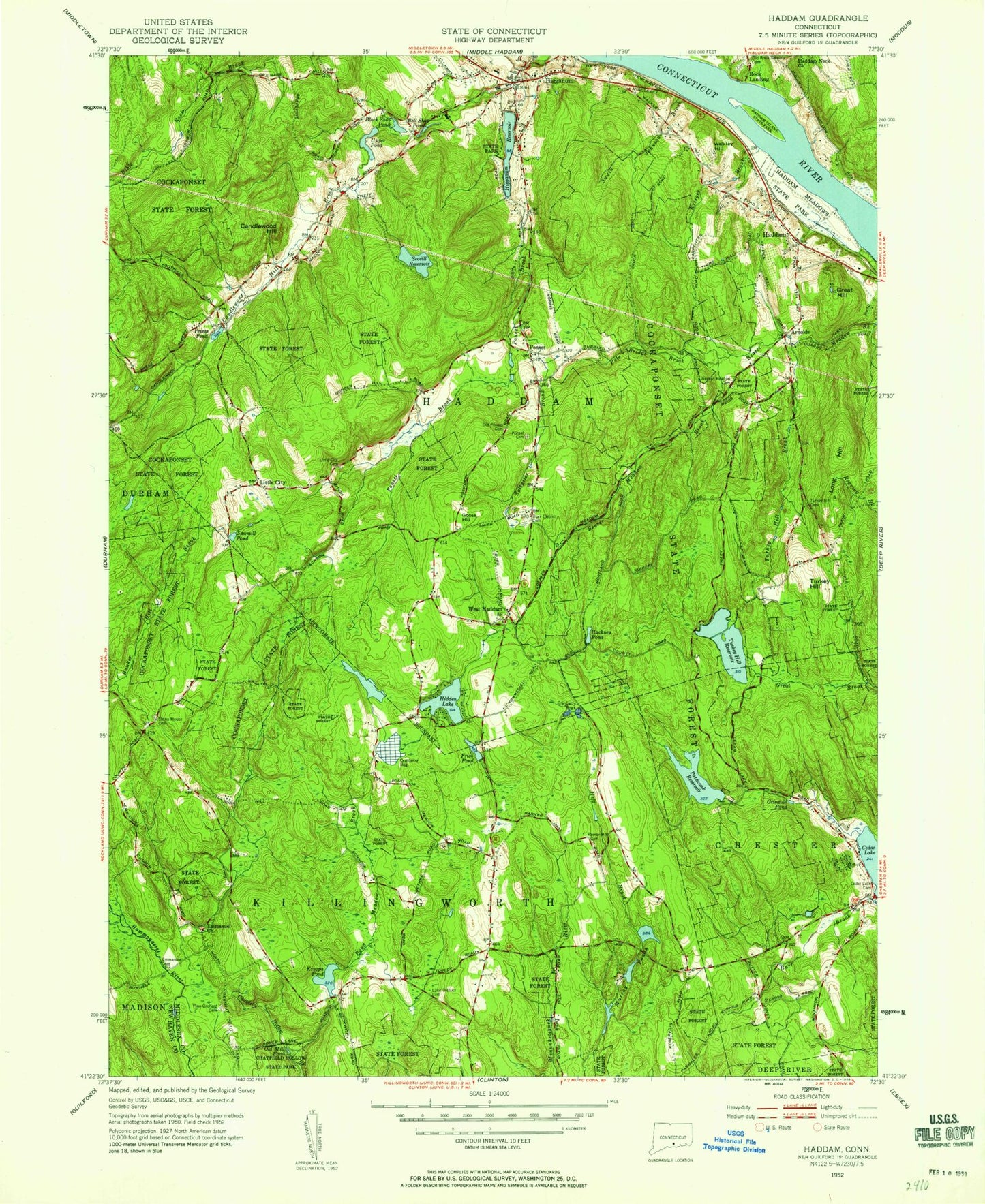
Classic USGS Haddam Connecticut 7.5'x7.5' Topo Map
Couldn't load pickup availability
Historical USGS topographic quad map of Haddam in the state of Connecticut. Typical map scale is 1:24,000, but may vary for certain years, if available. Print size: 24" x 27"
This quadrangle is in the following counties: Middlesex, New Haven.
The map contains contour lines, roads, rivers, towns, and lakes. Printed on high-quality waterproof paper with UV fade-resistant inks, and shipped rolled.
Contains the following named places: Arnolds, Beaver Meadow Brook, Bell Shop Pond, Bible Rock Brook, Black Shop Pond, Burr District Cemetery, Candlewood Hill, Candlewood Hill Brook, Cedar Lake Cemetery, Cockaponset State Forest, Emmanuel Church Cemetery, Emmanuel Church, Fricks Pond, Goose Hill, Great Hill, Griswold Pond, Hackney Pond, Haddam, Haddam Island State Park, Haddam-Killingworth Middle-High School, Haddam Meadows State Park, Hidden Lake, Higganum, Higganum Reservoir, Higganum Reservoir State Park, Horseshoe Pond, Kriegers Brook, Kroopa Pond, Lampes Pond, Lane District Cemetery, Little City, Little City Cemetery, Long Hill, Murray Ponds, Old Mill Pond, Old Ponset Cemetery, Palmers Pond, Parker Hill Cemetery, Pattaconk Reservoir, Pine Orchard Cemetery, Pole Bridge Brook, Pond Meadow Brook, Ponset, Ponset Brook, New Ponset Cemetery, Priess Pond, Saint Peters Church, Saltpeter Brook, Sawmill Pond, Scovill Reservoir, Stone House Cemetery, Swain Johnson Brook, Turkey Hill, Turkey Hill Brook, Turkey Hill Cemetery, Turkey Hill Reservoir, Upper Pond, Walkley Hill, West Haddam, Rock Landing, Haddam Island Bar, Red Store Landing, Warners Quarry Dock, Rock Landing Bar, Middlesex County, Chester Airport, Town of Haddam, Town of Killingworth, Pattaconk Reservoir Dam, Murray Pond Number 2 Dam, Murray Pond Number 2, Kroopa Pond Dam, Higganum Reservoir Dam, Scovill Reservoir Dam, Upper Pond Dam, Hidden Lake Dam, Big Hill, Brainerd Academy (historical), Bunker Hill, Burr District Elementary School, Cedar Lake, Gillette Quarry, Golden Ball Tavern (historical), Haddam Center Historic District, Haddam Elementary School, Haddam Island, Haddam Post Office, Haddam Town Hall, Higganum Congregational Church, Higganum Post Office, Higganum United Methodist Church, Lower Swamp, Meeting House Green, Old Rock Landing Cemetery, Ponset Episcopal Church, Red Store Landing (historical), Smith Landing (historical), Thankful Arnold House, Thirty Mile Island Plantation Burial Yard, Valley Bible Evangelical Church, Higganum Census Designated Place, Killingworth Volunteer Fire Company Station 2, Haddam Volunteer Fire Department Station 1 Headquarters, Haddam Volunteer Fire Department Station 3, Haddam Volunteer Fire Department Station 2, Chester Fire Department Station 2, Haddam Volunteer Ambulance Service, Haddam Center Cemetery