


MyTopo
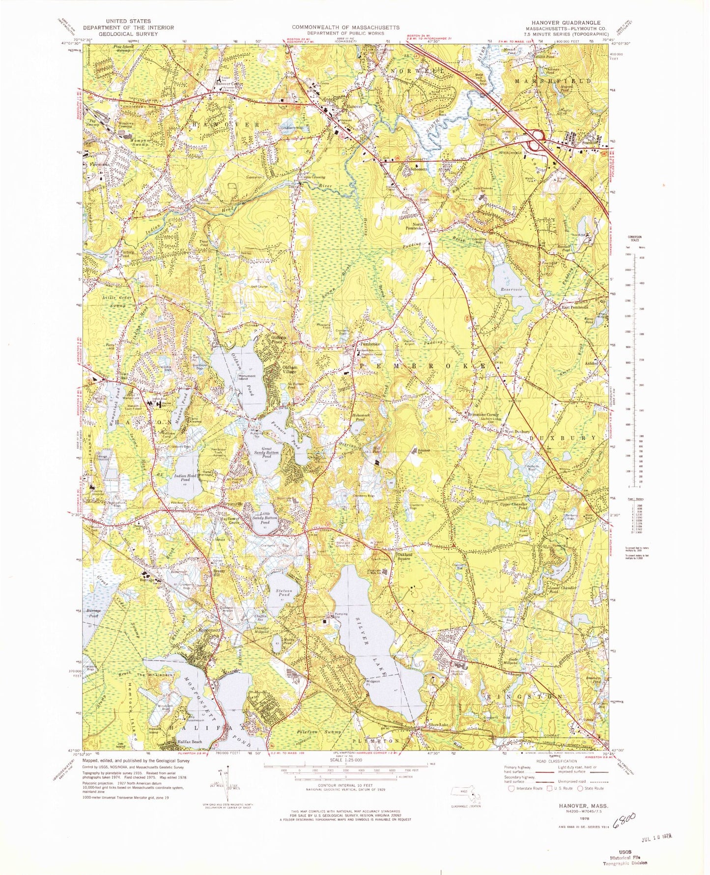
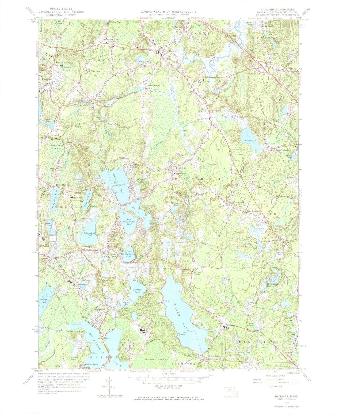
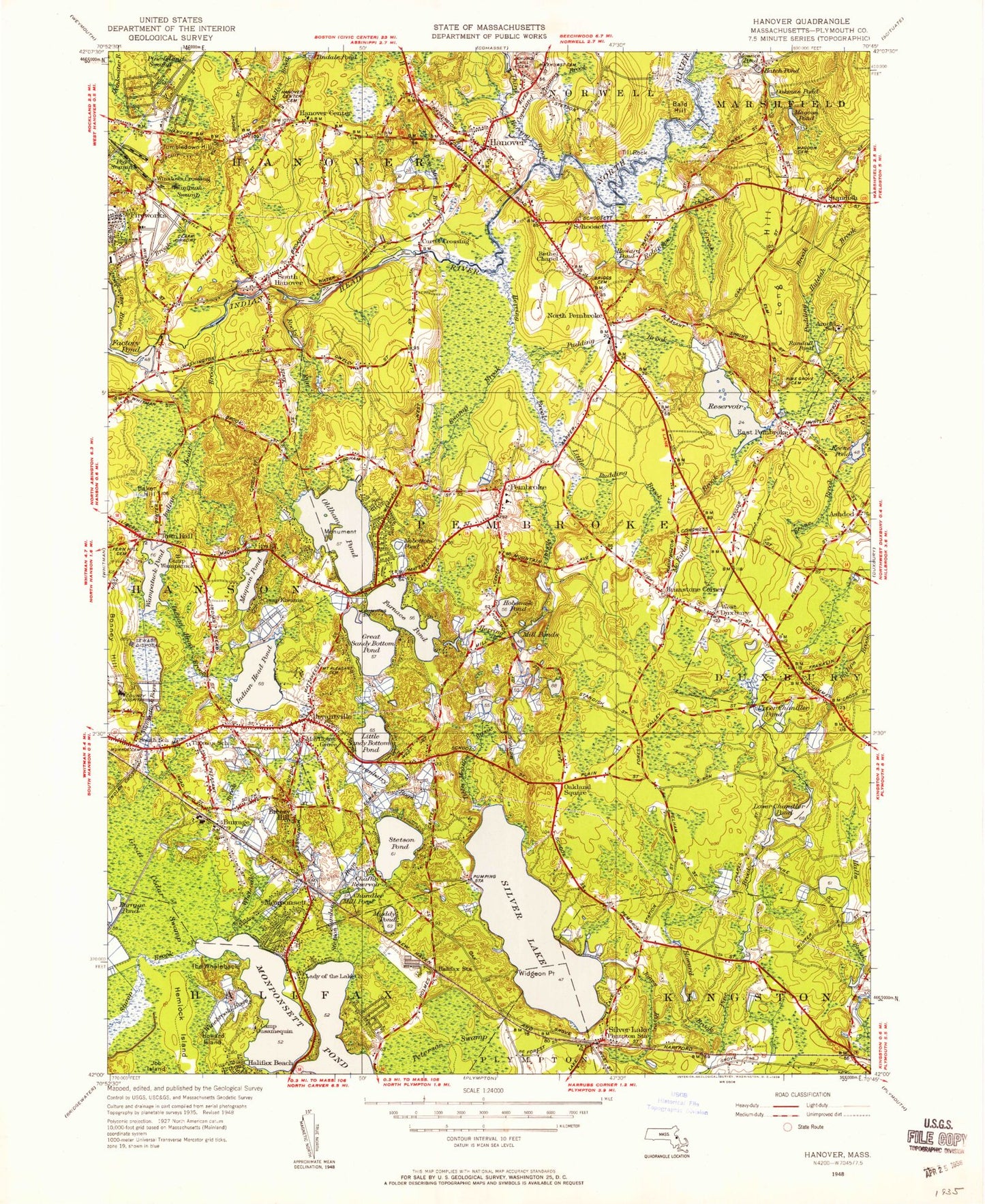
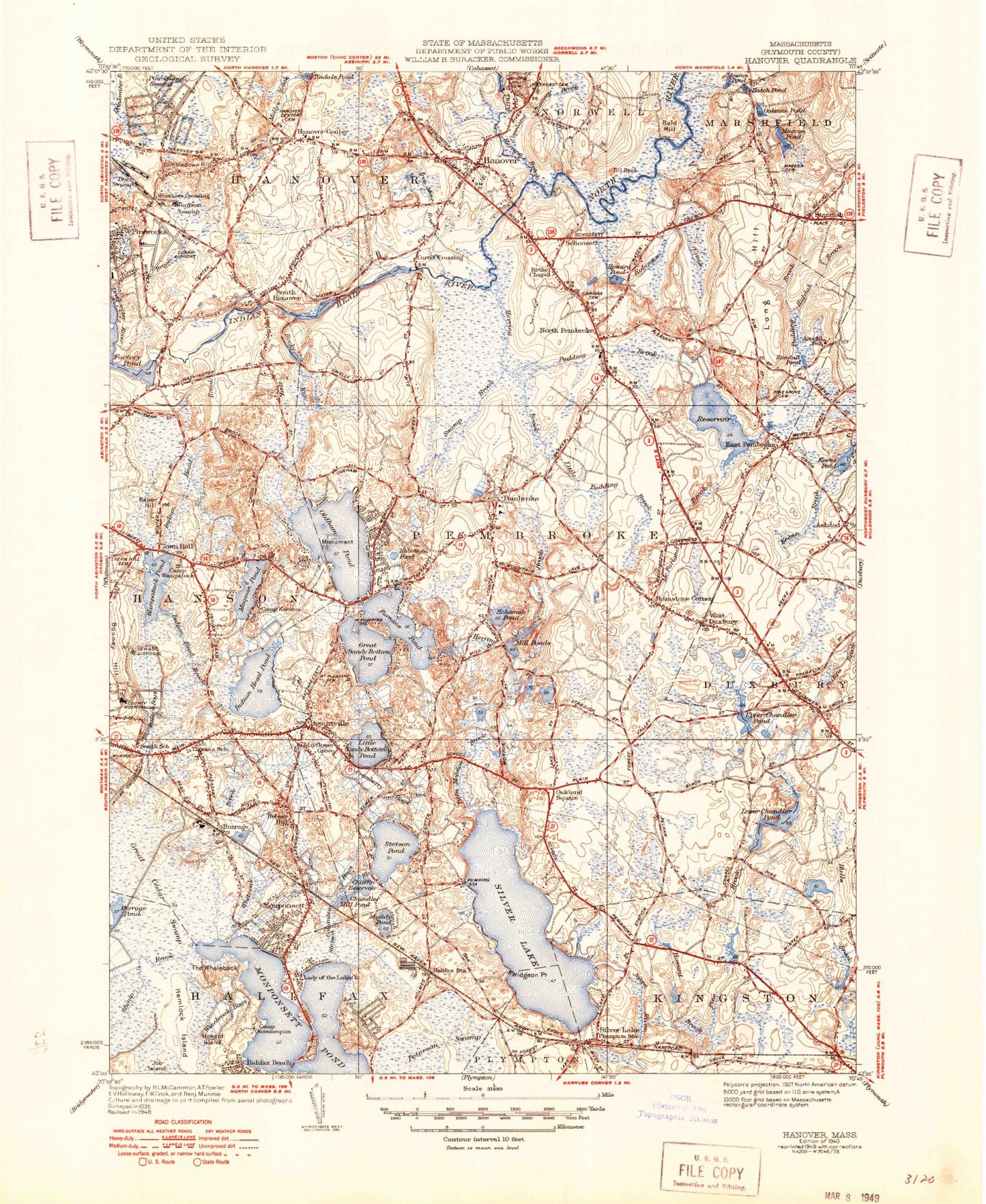
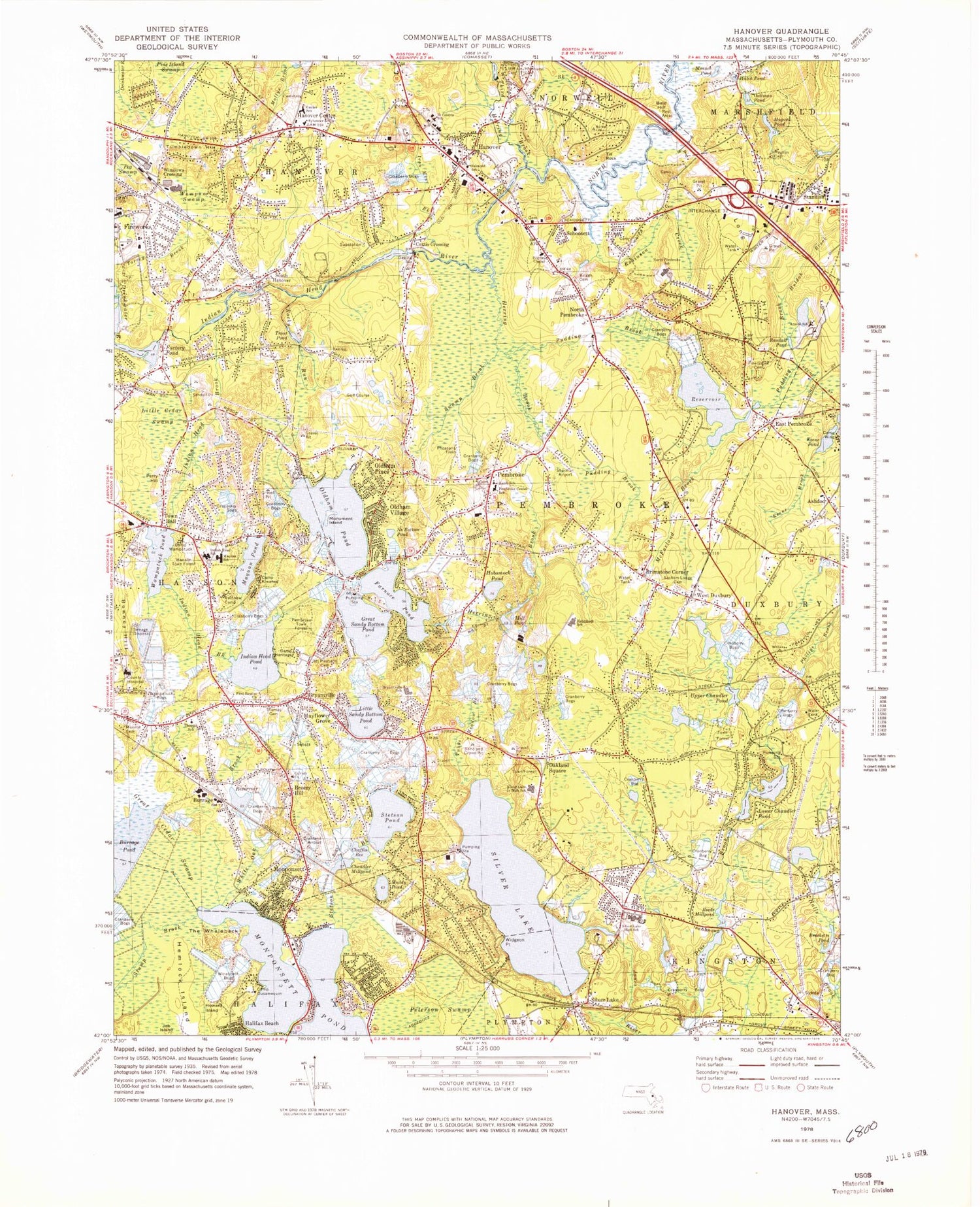
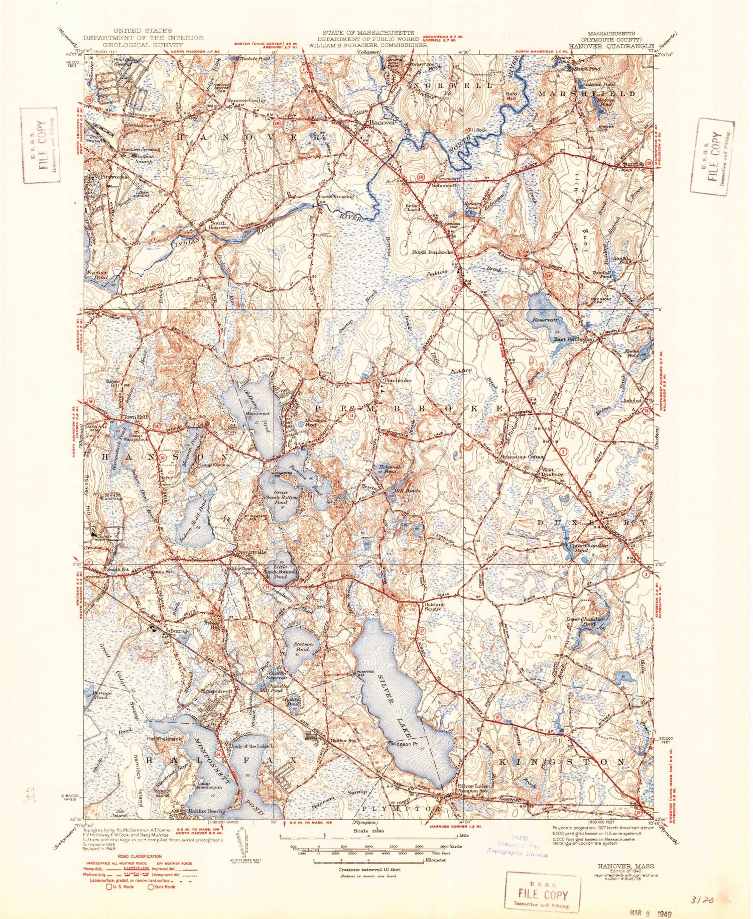
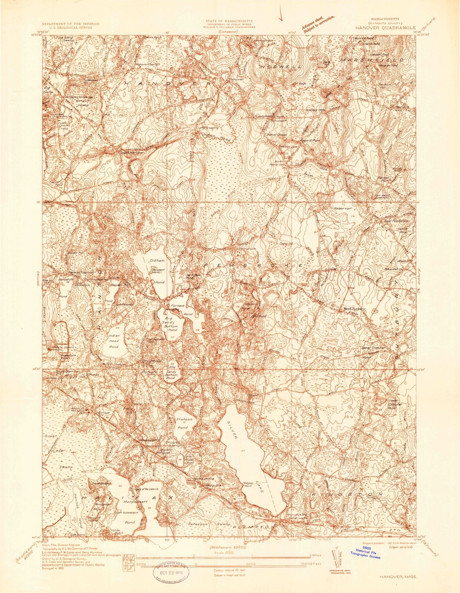
Classic USGS Hanover Massachusetts 7.5'x7.5' Topo Map
Couldn't load pickup availability
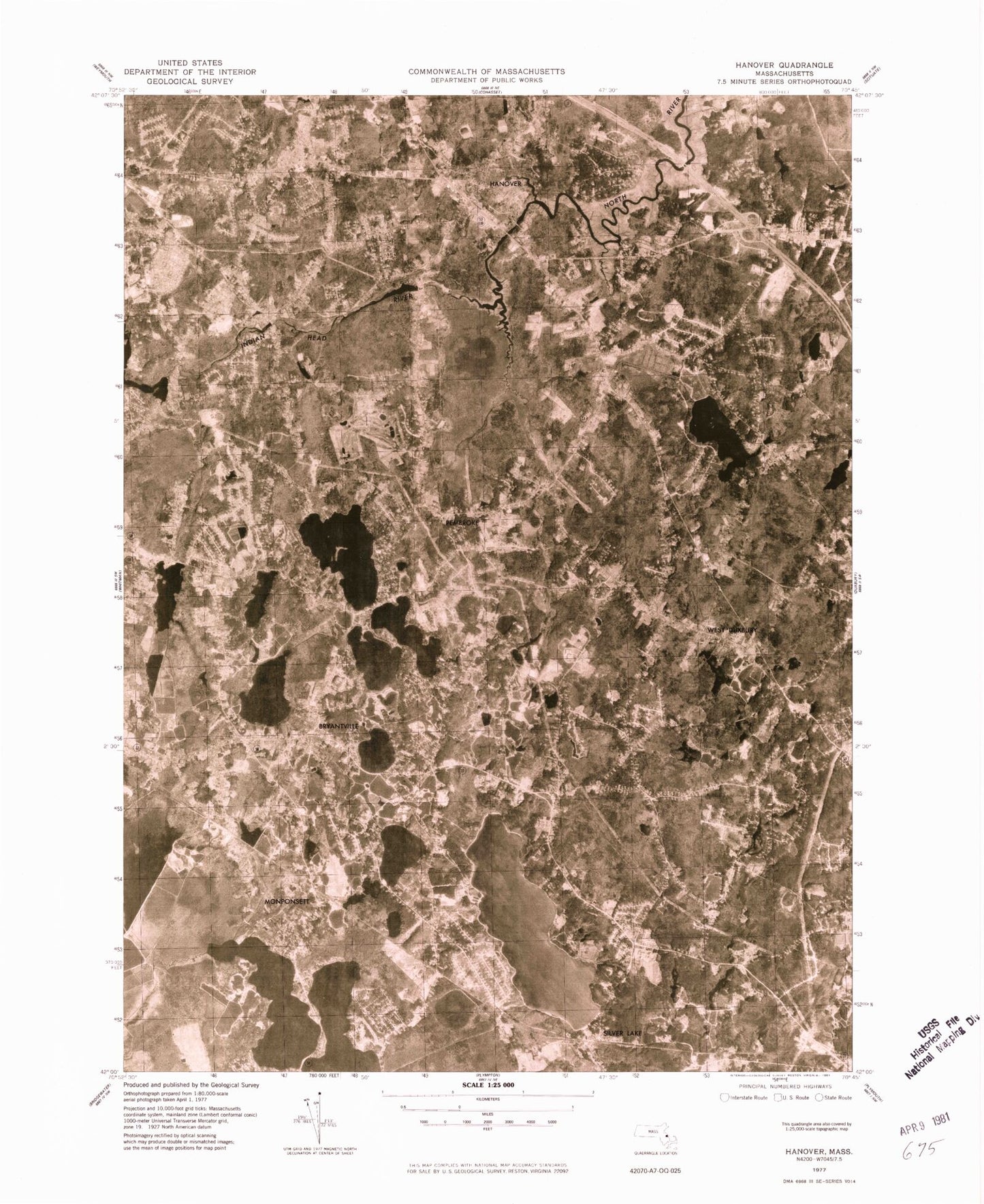
Historical USGS topographic quad map of Hanover in the state of Massachusetts. Typical map scale is 1:24,000, but may vary for certain years, if available. Print size: 24" x 27"
This quadrangle is in the following counties: Plymouth.
The map contains contour lines, roads, rivers, towns, and lakes. Printed on high-quality waterproof paper with UV fade-resistant inks, and shipped rolled.
Contains the following named places: Burrage Pond, Camp Wing, Camp Ousamequin, Camp Wampatuck, Rainbow Camp, Camp Kiwanee, Camp Heritage, Winebrook Bags, Columbia Bogs, Pembroke Town Forest, Hanson Town Forest, North Pembroke Elementary School, Thomas School, Sachem Lodge Cemetery, Paul Magoun Cemetery, Thomas Cemetery, Hatch School, Pembroke Center School, Fern Hill Cemetery, Hobomock Elementary School, Arnold School, Pine Grove Cemetery, Briggs Burying Ground Cemetery, Magoun Cemetery, Church Hill Cemetery, Pinehurst Cemetery, Pilgrim Chapel, Saint Coletta School, Bryantville Elementary School, Salmond School, Maquan Elementary School, Munroe Cemetery, Silver Lake Regional Kingston School, Silver Lake Regional Junior High School, Calvary Church, Plymouth County Hospital, First Baptist Church, Boerne Crossing Station (historical), Silver Lake Station (historical), Hanover Station (historical), Hanover Square, Hanover Plaza, Tedeschi Shopping Center, Standish Village Plaza, Pembroke Shopping Center, Hanson Shopping Center, Kelleher Dam, Bracketts Pond Dam, Reed Mill Pond Dam, Silver Lake Dam, Burrage Pond Dam - Upper Reservoir Flume, Halls Brook Reservoir, Halls Brook Dam, Lower Chandler Pond Dam, Burrage Upper Reservoir Dam, Burrage Pond Dam, Hill Pond Dam, Hill Pond, Upper Chandler Pond Dam, Stumpey Pond Upper Dam, Gorham Dam Number 2, Mill Pond Lower Dam, Wampatuck Pond Dam, Keene Pond Dam, Stump Pond, Stump Pond Dam, Factory Pond Dam, Arnold Reservoir, Arnold Reservoir Dam, Trout Pond Dam, Indian Head River Reservoir, Indian Head Dam, Indian Head River Reservoir, Curtis Crossing Dam, Magoun Pond Dam, Ashdod, Bald Hill, Bracketts Pond, Breezy Hill, Bryantville, Brimstone Corner, Burrage, Camp Kiwanis, Camp Ousamequin, Camp Wampatuck, Chaffin Reservoir, Chandler Millpond, Copeland Tannery Brook, Curtis Crossing, Drinkwater River, East Pembroke, Factory Pond, Fireworks, Furnace Pond, Golden Ring Camp, Great Cedar Swamp, Great Sandy Bottom Pond, Halifax Beach, Hanover, Hanover Center, Hatch Pond, Hemlock Island, Herring Brook, Hobomock Pond, Howard Island, Howard Pond, Huldah Brook, Indian Head Brook, Indian Head Pond, Indian Head River, Iron Mine Brook, Job Island, Keene Pond, Little Cedar Swamp, Little Pudding Brook, Little Sandy Bottom Pond, Long Hill, Lower Chandler Pond, McFarland Brook, Magoun Pond, Maquan Pond, Mayflower Grove, Mill Pond, Mollys Brook, Monponsett Pond, Monument Island, Mounce Pond, Muddy Pond, No Bottom Pond, North Pembroke, Oakland Square, Oakman Pond, Oldham Pines, Oldham Pond, Oldham Village, Peg Swamp, Pembroke, Perry Hill, Peterson Swamp, Pine Island Swamp, Pudding Brook, Randall Pond, Reeds Millpond, Robinson Creek, Rocky Run, Schoosett, Silver Lake, Silver Lake, South Hanover, Standish, Stetson Brook, Stetson Pond, Stump Brook, Swamp Brook, Third Herring Brook, Till Rock, Tindale Pond, Torrey Brook, Town Hall, Trout Pond, Tubbs Meadow Brook, Tumbledown Hill, Upper Chandler Pond, Wampatuck Bogs, Wampatuck Pond, Wampum Swamp, West Duxbury, The Whaleback, White Oak Brook, Widegeon Point, Winslows Crossing, Winebrook Bogs, Monponsett, Gurneys Corner, Alfred G Zanetti School, Queen Brook, Town of Hanover, Town of Pembroke, Stump Pond (historical), Bryantville Post Office (historical), Silver Lake Post Office (historical), West Dunbury Post Office (historical), East Pembroke Post Office (historical), Pembroke Post Office (historical), South Hanover Post Office (historical), Four Corners Post Office (historical), North Pembroke Post Office (historical), Monponsett Pond Seaplane Base, Cranland Airport, Sherman-Private Airport, Pheasant Field, Town of Hanson, Arnold Hall, Bryantville Post Office, Bryantsville United Methodist Church, Center Elementary School, Clark Airport (historical), Dubby Point, East Lake, First Church in Pembroke, First Congregational Church, Glover Mill Pond, Gorham Mill Pond, Halifax Station (historical), Hanover Center Cemetery, Hanover Fire Station, Hanover Post Office, Hanover Town Hall, Hanson Post Office, High Street United Methodist Church, Hobomock Arena, John Curtis Free Library, Kingston Fire Department Station 1 Headquarters, Lady of the Lake Church, Lutheran Church of the Cross, Marshfield United Methodist Church, Memorial Field, Monponsett Post Office, North Pembroke Post Office, North River Plaza Shopping Center, Pembroke Country Club, Pembroke Hospital, Pembroke Post Office, Pembroke Town Hall, Phillips Mill Pond, Plymouth Bay Church, Plympton Station (historical), Randall Swamp, Riverwind Estates, Saint Andrews Episcopal Church, School Number 3 (historical), Shaws Plaza Shopping Center, South School (historical), West Lake, Wingbrook Estates, Pembroke Community Middle School