MyTopo
Classic USGS Jewett City Connecticut 7.5'x7.5' Topo Map
Couldn't load pickup availability
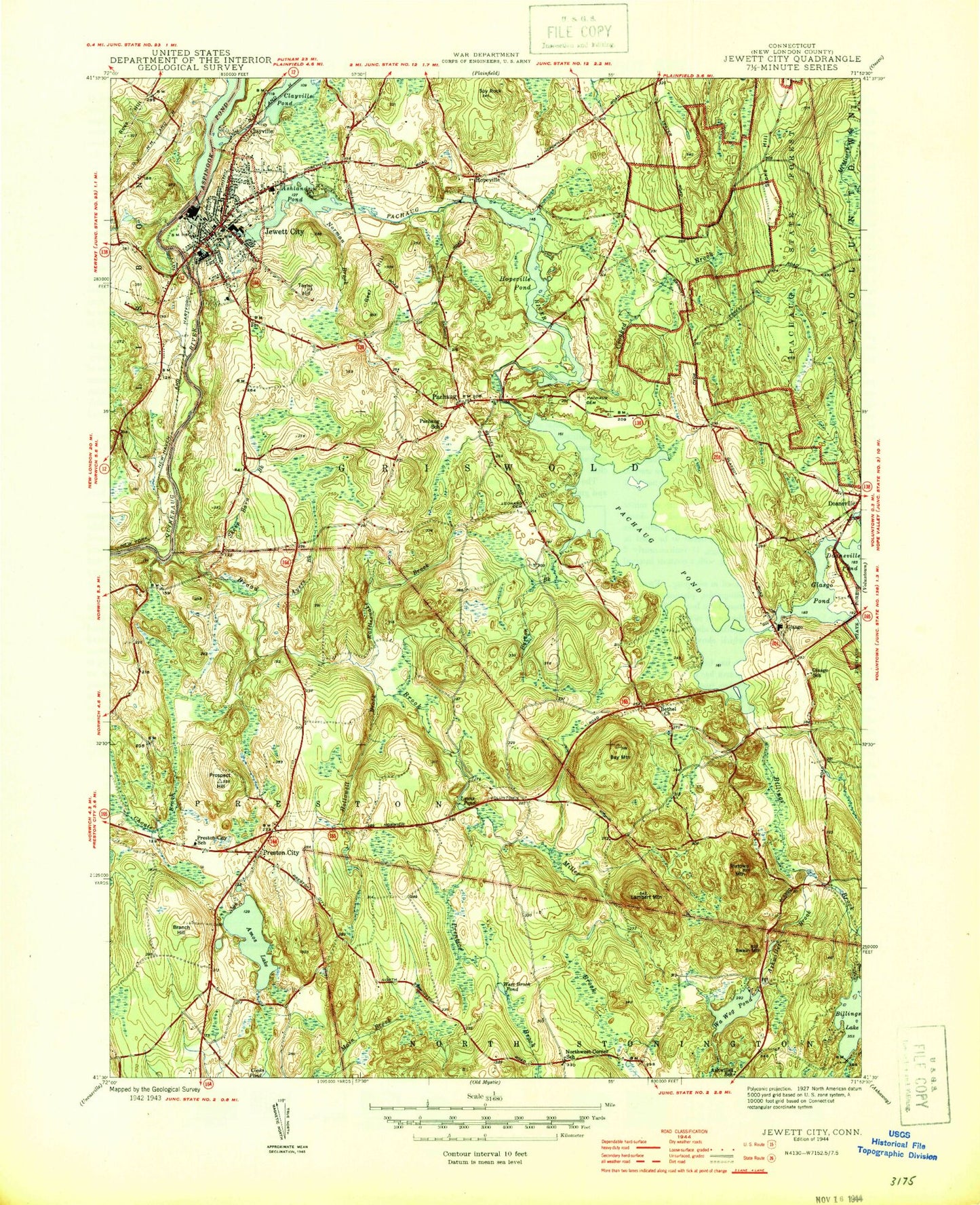
Historical USGS topographic quad map of Jewett City in the state of Connecticut. Typical map scale is 1:24,000, but may vary for certain years, if available. Print size: 24" x 27"
This quadrangle is in the following counties: New London.
The map contains contour lines, roads, rivers, towns, and lakes. Printed on high-quality waterproof paper with UV fade-resistant inks, and shipped rolled.
Contains the following named places: Amos Lake, Anderson Pond, Ashland Pond, Ashwillet Brook, Ayers Brook, Bay Mountain, Bethel Church, Billings Brook, Billings Lake, Broad Brook, Burton Brook, Clayville Pond, Crooked Brook, Geer Hill, Glasgo Pond, Glasgo School, Folly Works Brook, Hopeville Pond, Hopeville Pond State Park, Jewett City, Leonard Cemetery, Lewis Pond, Miller Brook, Norman Brook, Pachaug Cemetery, Pachaug Pond, Pachaug River, Pachaug State Forest, Prentice Brook, Preston School, Prospect Hill, Rattlesnake Brook, Ross Hill, Round Hill, Sheep Barn Brook, Spy Rock, Stone Hill, Taylor Hill, Clayville, Doaneville, Glasgo, Hopeville, Pachaug, Lakeside Airport (historical), Spruce Airport, Town of Griswold, Preston City, Glasgo Pond Dam, Ashland Pond Dam, Hopeville Pond Dam, Aspinook Pond Dam, Billings Lake Dam, Blue Lake Dam, Blue Lake, Pachaug Pond Dam, Ashwillet School (historical), Barton Island, Bethel, Breakneck Hill, Brown Cemetery, Calvary Bible Church, Calvin Wilcox Pond, Campers World Campground, Crary Cemetery, Cutler Brook, Davis Cemetery, Dorrville (historical), Edmonds Brook, Edmonds Cove, First Congregational Church, Fobes - Amos Cemetery, Glasgo Post Office, Glasgo School (historical), Griswold High School, Grist Mill Pond, Jewett City Baptist Church, Jewett City Post Office, Jewett City Town Hall, Northwest Corner School (historical), Pachaug Green, Pachaug School (historical), Partridge Brook, Popple Bridge (historical), Preston City Congregational Church, Preston City Historic District, Preston City School, Preston Highway Park, Ross Hill Campgrounds, Saint Catherine Church, Saint Marys Church, Sand Plains, Second Congregational Church, Sterrie Brook, Stickmeadow (historical), Woodmansee Pond, YMCA Camp, Borough of Jewett City, Preston City Fire Company, Jewett City Fire Department, Griswold Fire Marshal's Office, Griswold Volunteer Fire Department Station 55, Griswald Fire Company, Bee Field, American Legion Ambulance, Jewett City Resident State Patrol Office, Amos Lake, Anderson Pond, Ashland Pond, Ashwillet Brook, Ayers Brook, Bay Mountain, Bethel Church, Billings Brook, Billings Lake, Broad Brook, Burton Brook, Clayville Pond, Crooked Brook, Geer Hill, Glasgo Pond, Glasgo School, Folly Works Brook, Hopeville Pond, Hopeville Pond State Park, Jewett City, Leonard Cemetery, Lewis Pond, Miller Brook, Norman Brook, Pachaug Cemetery, Pachaug Pond, Pachaug River, Pachaug State Forest, Prentice Brook, Preston School, Prospect Hill, Rattlesnake Brook, Ross Hill, Round Hill, Sheep Barn Brook, Spy Rock, Stone Hill, Taylor Hill, Clayville, Doaneville, Glasgo, Hopeville, Pachaug, Lakeside Airport (historical), Spruce Airport, Town of Griswold, Preston City, Glasgo Pond Dam, Ashland Pond Dam, Hopeville Pond Dam, Aspinook Pond Dam, Billings Lake Dam, Blue Lake Dam, Blue Lake, Pachaug Pond Dam, Ashwillet School (historical), Barton Island, Bethel, Breakneck Hill, Brown Cemetery, Calvary Bible Church, Calvin Wilcox Pond, Campers World Campground, Crary Cemetery, Cutler Brook, Davis Cemetery, Dorrville (historical), Edmonds Brook, Edmonds Cove, First Congregational Church, Fobes - Amos Cemetery, Glasgo Post Office, Glasgo School (historical), Griswold High School, Grist Mill Pond, Jewett City Baptist Church, Jewett City Post Office, Jewett City Town Hall, Northwest Corner School (historical), Pachaug Green, Pachaug School (historical), Partridge Brook, Popple Bridge (historical), Preston City Congregational Church, Preston City Historic District, Preston City School, Preston Highway Park, Ross Hill Campgrounds, Saint Catherine Church, Saint Marys Church, Sand Plains, Second Congregational Church, Sterrie Brook, Stickmeadow (historical), Woodmansee Pond, YMCA Camp, Borough of Jewett City, Preston City Fire Company, Jewett City Fire Department, Griswold Fire Marshal's Office, Griswold Volunteer Fire Department Station 55, Griswald Fire Company, Bee Field, American Legion Ambulance, Jewett City Resident State Patrol Office