MyTopo
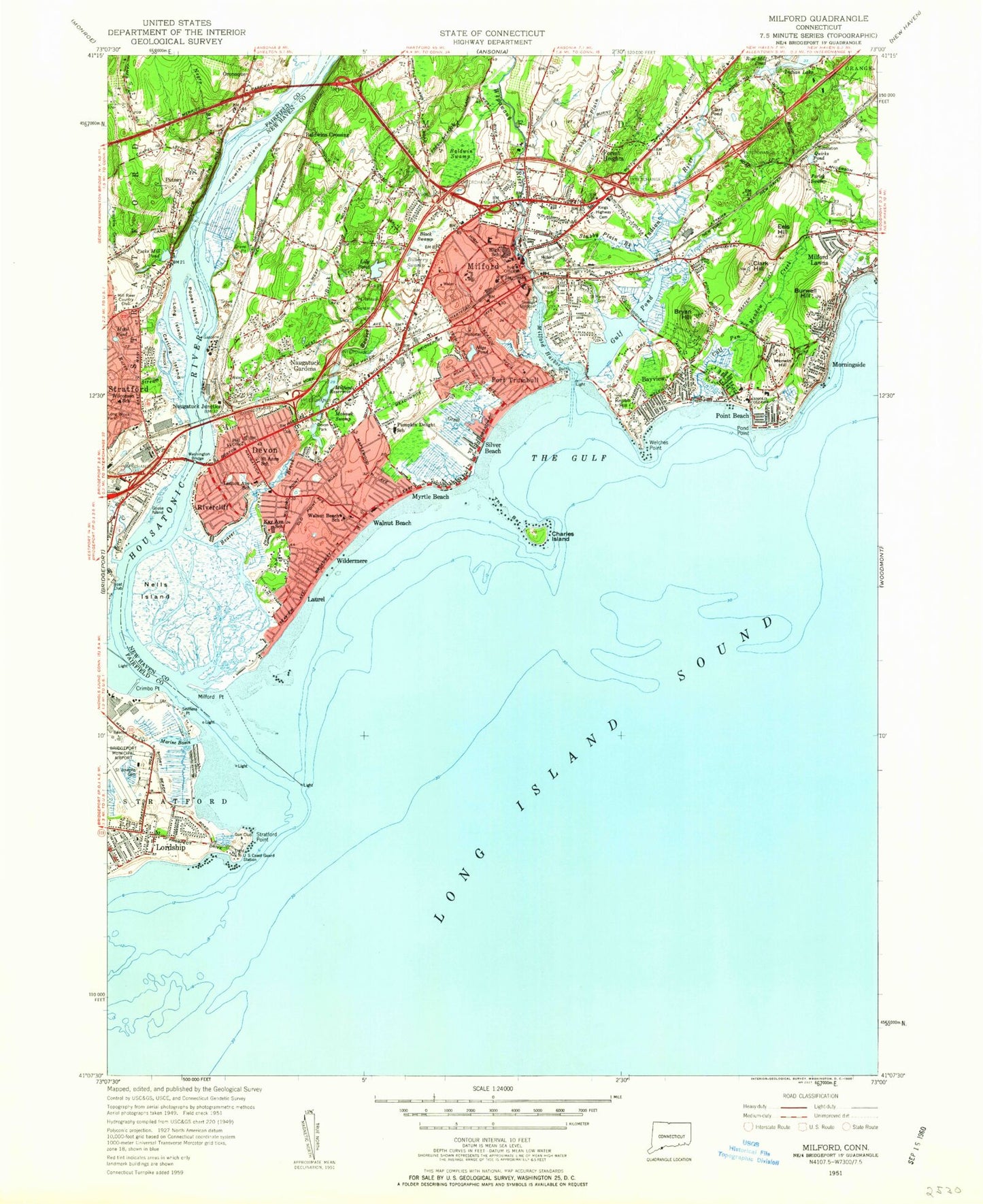
Classic USGS Milford Connecticut 7.5'x7.5' Topo Map
Couldn't load pickup availability
Historical USGS topographic quad map of Milford in the state of Connecticut. Typical map scale is 1:24,000, but may vary for certain years, if available. Print size: 24" x 27"
This quadrangle is in the following counties: Fairfield, New Haven.
The map contains contour lines, roads, rivers, towns, and lakes. Printed on high-quality waterproof paper with UV fade-resistant inks, and shipped rolled.
Contains the following named places: Baldwin Swamp, Bayview, Bayview Beach, Beaver Brook, Billberry Swamp, Black Swamp, Putney - Oronoque Cemetery, Bryan Hill, Burns Point, Burwell Hill, Burwells Beach, Calf Pen Meadow Creek, Calf Pen Meadow School, Carting Island, Cedar Beach, Chapel Street School, Charles Island, Clark Hill, Clark Pond, Crimbo Point, Devon, Dismal Swamp, Eels Hill, Farley Swamp, Farview Beach, Ferry Creek, Forest Heights, Fort Trumbull, Fort Trumbull Beach, Fowler Island, Goose Island, Great Creek, Gulf Beach, Gulf Pond, Indian River, West Shore Middle School, Kings Highway Cemetery, Knobb Hill, Laurel Beach, Jonathan Law High School, Lennox Avenue School, Lily Pond, Long Brook Park, Long Island, Lordship, Lordship Beach, Marine Basin, Meadowside School, Merwin Hill, Milford, Milford Cemetery, Milford Harbor, Milford Lawns, Milford Point, Milford Reservoir, Mohawk Swamp, Morningside, Motil Pond, Myrtle Beach, Naugatuck Gardens, Freeman Brook, Nells Island, Walker Pond, Osauge Avenue School, Peacock Island, Pecks Mill Pond, Point Beach, Pond Point, Popes Island, Pumpkin Delight School, Pumpkin Ground Brook, Quirks Pond, Raven Stream, Rivercliff, Saint Anns School, Saint Marys Cemetery, Seabreeze School, Selby Pond, Short Beach, Silver Beach, Simon Lake School, Sniffens Point, Stratford Point, Stubby Plain Brook, Stubby Plain Brook, The Bar, The Gulf, Walnut Beach, Washington Bridge, Wepawaug River, Wilcox Park, Wilcoxson School, Wildermere Beach, Baldwins Crossing, Naugatuck Junction, Oronoque, Putney, Housatonic River, Oronoque Bar, Pecks Mill, Johnsons Corner, Mary Ann Bar, Pond Point Beach, Mill Bar, Culvar Bar, WFIF, Spring Pond Park, Welches Point, Mill River Country Club, Milford-Alexander Heliport, Consumer Products Division/Warner-Lambert Company Heliport, Sikorsky Heliport, WFIF-AM (Milford), Town of Milford, Beaver Brook Dam, Indian Lake Dam, Mary Ann Bar, Mary Taylor United Methodist Church, Mathewson Playground, Mathewson School, Meadowside Playground, Melba Shopping Plaza Shopping Center, Memorial Bridge, Milford Academy, Milford Chamber of Commerce, Milford City Hall, Milford Green, Milford Historical Society Complex, Milford Hospital, Milford Mental Health Clinic, Milford Plaza Shopping Center, Milford Post Office, Milford Public Library, Milford Yacht Club, Morningside Beach, Naugatuck Avenue Shopping Center, Old Gate Shopping Center, Orchard Hills School, Outer Breakwater, Parsons Government Center, Pergament Center Shopping Center, Platt Regional Vocational Technical Center, Plymouth Church, Point Beach, Pond Point Beach, Pond Point Shopping Center, Prudden Point, Robert Hutchins Parkette, Saint Anns Roman Catholic Church, Saint Gabriel School, Saint Mary School, Saint Peters Episcopal Church, Silver Sands State Park, Stockadge Shoppes Shopping Center, Taylor Memorial Library, Tri Beach Country Club, United Church of Christ, United Pentecostal Church, Upper Lagoon, Walnut Public Beach, Washington Field, Welchs Point Park, Wildemere Beach Church, Wildemere Station Post Office, Woodmont United Church of Christ, Academy of Our Lady of Mercy, Anderson Avenue Playground, Arnold College, Baldwin Marsh Wildlife Area, Baldwin Point, Beard Cove (historical), Beaver Brook Ponds, Berean Assembly of God Church, Brewster Field, Burns Point Jetty, Calf Pen Meadow, Calvary Alliance Church, Charles E Wheeler Wildlife Area, Christ the Redeemer Roman Catholic Church, Clark Tavern (historical), Connecticut Audubon Coastal Center, Connecticut Post Mall Shopping Center, Cornerstone Christian Center, Davenport Playground, Devon Post Office, Duck Island, First Baptist Church, First Congregational Church, First United Church of Christ, Fowler Memorial, Grace Baptist Church, Great Lots Cove (historical), Gulf Beach, Gulf Bridge, Harborside Middle School, Indian Neck, Inner Breakwater, John F Kennedy School, Joseph A Foran High School, Laurelton Hall, Long Jetty, Margaret Egan Center Park, Bonds Dock, Boothe Memorial Museum, Evangelical Assembly of God Church, Great Neck School, Harry B Flood Middle School, Harry B Flood High School, Housatonic Boat Club, Johnsons Corner (historical), Lordship Community Church, Oronoque Hills South, Our Lady of Peace Church, Peck Great Cove (historical), Pecks Mill (historical), Pecks Mill Pond Park, Pootatuck Yacht Club, Prospect Hill, Remington Gun Club, Short Beach Golf Course, Short Beach Park, Stratford Lighthouse, The Dock Shopping Center, Yeomans Park and Athletic Field, Lower Lagoon, Bridgeport Army Air Field (historical), City of Milford (balance), City of Milford, Milford Fire Department Headquarters, Milford Fire Department Station 6, Milford Fire Department Station 7, Milford Fire Department Station 8, Coast Guard Station New Haven, Laurel Beach, Milford Police Department, Downtown Milford Post Office