
MyTopo
USGS Classic Mount Washington New Hampshire 7.5'x7.5' Topo Map
Couldn't load pickup availability
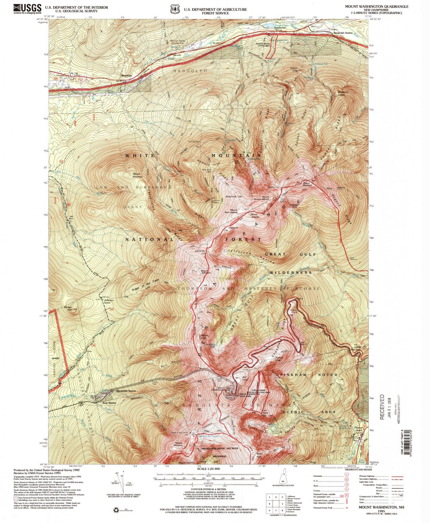
Historical USGS topographic quad map of Mount Washingtonin the states of New Hampshire, Maine. Scale: 1:24000. Print size: 24" x 27"
This quadrangle is in the following counties: Coos.
The map contains contour lines, roads, rivers, towns, lakes, and grids including latitude / longitude and UTM / MGRS. Printed on high-quality waterproof paper with UV fade-resistant inks.
Contains the following named places: Old Jackson Road, Osgood Ridge, Parapet Brook, Randolph Trail, Randolph Station, Ravine Path, Raymond Path, Short Line, Six Husbands Trail, Snyder Brook, Spaulding Lake, Sphinx Trail, Spur Brook, Spur Path, Star Lake, Sylvan Way Trail, Tuckerman Ravine, Valley Way, Wamsutta Trail, Watson Path, Westside Trail, Mount Quincy Adams, Mount Sam Adams, Mount Washington, Lows Bald Spot, Mount Abigail Adams, Adams Five, Adams Slide Trail, Mount Adams, Air Line, Alpine Garden Trail, Appalachia, Ball Crag, Blue Berry Ledge Bench, Boott Spur, Boott Spur Trail, Bowman, Mount Bowman, Bumpus Brook, Burt Ravine, Buttress Trail, Carlton Brook, Cascade Brook, Castellated Ridge, Castle Brook, Castle Path, Chandler Brook, Chandler Ridge, Chandlers Purchase, Clay Brook, Mount Clay, Lakes of the Clouds, Cold Brook, Cold Brook, Coosauk Fall, Cutler River, Davis Path, Durand Ridge, Edmands Col, Franklin Brook, Mount Franklin, Gordon Ridge, Great Gulf, Gulfside Trail, Hermit Lake, Hitchcock Falls, Howker Ridge, Howker Ridge Path, Huntington Ravine, Israel Ridge, Jefferson Notch, Jefferson Ravine, Mount Jefferson, Jewell Trail, Kelton Crag, King Ravine, Lion Head, Low and Burbanks Grant, Lowes Path, Madison Gulf, Madison Gulf, Mount Madison, Marshfield Station, Millen Hill, Monroe Brook, Mount Monroe, Nelson Crag, Nelson Crag Trail, New River, Nowell Ridge, Osgood Trail, Pinkham Notch, Ridge of the Caps, The Link, The Mystic, Thompson and Meserves Purchase, White Mountains, Pinkham Notch Scenic Area, Great Gulf Wilderness, Great Gulf Shelter, WZPK-FM (Berlin), WHOM-FM (Mount Washington), Pinkham Notch Camp (historical), Bowman Bose Camp, Randolph Springs Wayside ARea, Summit House, Tip-Top House, Ravine of the Castles, Ravine of the Cascades, Randolph Fire Department, Alpine Gardens, Agiocochook Crag, Bigelow Lawn, Pinkham Notch Visitor Center, Washburn Point, White Mountains


