MyTopo
Classic USGS Mystic Connecticut 7.5'x7.5' Topo Map
Couldn't load pickup availability
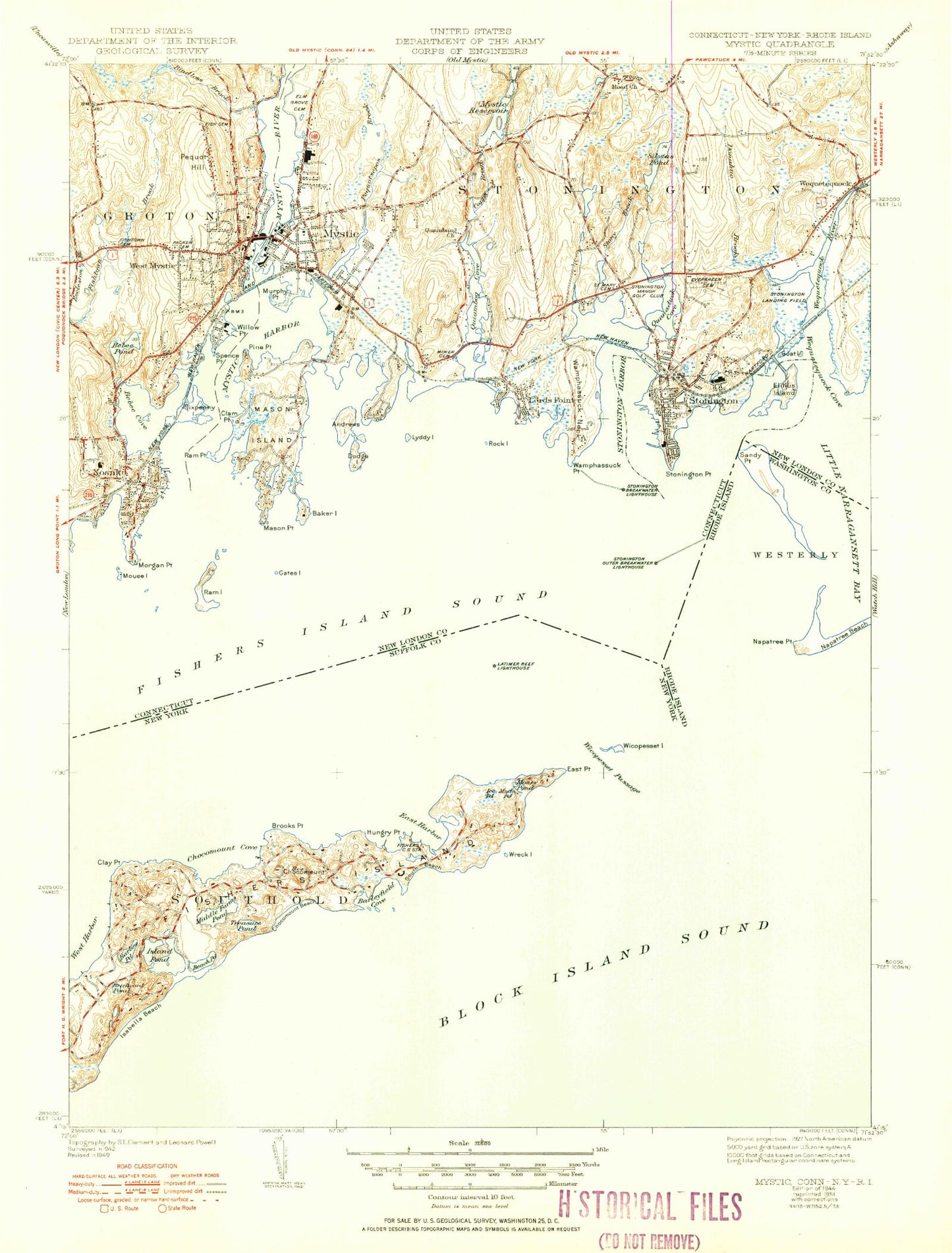
Historical USGS topographic quad map of Mystic in the states of Connecticut, New York. Typical map scale is 1:24,000, but may vary for certain years, if available. Print size: 24" x 27"
This quadrangle is in the following counties: New London, Suffolk, Washington.
The map contains contour lines, roads, rivers, towns, and lakes. Printed on high-quality waterproof paper with UV fade-resistant inks, and shipped rolled.
Contains the following named places: Andrews Island, Beebe Cove, Beebe Pond, Bindloss Brook, Clam Point, Copps Brook, Cormorant Reef, Dodges Island, Donahue Brook, Eccleston Brook, Elihu Island, Elm Grove Cemetery, Stonington Cemetery, Fish Cemetery, Fishers Island Sound, Fishtown Cemetery, Gates Island, Goat Island, Hilliard Cemetery, Lords Point, Lords Point, Lyddy Island, Miner Cemetery, Mouse Island, Murphy Point, Mystic, Mystic Harbor, Mystic Reservoir, Mystic River, Noank, Noyes Rock, Noyes Shoal, Packer Cemetery, Pequot Hill, Pequotsepos Brook, Pine Point, Pine Point School, Planet Rock, Quambaug Church, Quanaduck Cove, Quiambog Cove, Ram Island, Ram Point, Red Reef, Road Church, Rock Island, Saint Mary's Cemetery, Seal Rocks, Silvias Pond, Sixpenny Island, Spence Point, Stonington, Stonington Harbor, Stonington Point, Stony Brook, Swimming Rock, Twin Brothers, Wamphassuc Neck, Wamphassuc Point, Wequetequock, Wequetequock Cove, West Cove, West Mystic, Whale Rock, Whaleback Rock, White Rock, Willow Point, Wequetequock River, Mystic Seaport, Eel Grass Ground, Ram Island Shoal, Enders Island, Ellis Reef, Mason Island, Mason Point, Morgan Point, Stonington Airpark, Town of Stonington, West Rutland Cemetery, Silvias Pond Dam, Deans Reservoir Dam, Abigail Point, Barn Island Wildlife Management Area, Bass Strait, Bel-Aire Park, Borough Hall, Brewster Yacht Yard, Calvary Episcopal Church, Cannon Square, Carl C Cutler Middle School, Church of God, Collins Cove, Cottrell Wharf (historical), Deans Mill Elementary School, Denison Homestead, Denison Burial Ground, Dodson Boat Yard, DuBois Beach, East Breakwater, Esker Point, Esker Point Beach, First Church of Christ Scientist, First United Methodist Church, G W Blunt White Library, Saint Patrick Cemetery, Holmes Wharf (historical), Ice Harbor, Lamberts Cove, Lobster Cove, Marinelife Aquarium, Masons Island Cemetery, Mason Island Marina, Mason Island Yacht Club Pier, Mason Monument, Mason Neck, Mine Cove, Mistack, Money Point, Morgan Point Lighthouse, Mud Cove, Mud Point, Mystic Art Gallery, Mystic Bascule Bridge, Mystic Bridge Historic District, Mystic Community Center, Mystic Congregational Church, Mystic Factory Outlet I Shopping Center, Mystic Factory Outlet II Shopping Center, Mystic Middle School, Mystic Marinelife Aquarium Research Library, Mystic Post Office, Mystic Ridge Subdivision Park, Mystic Seaport Marine Museum, Mystic Shipyard, Mystic Station, Mystic-Noank Library, Nauyaug Coast, Noank Baptist Church, Noank Elementary School, Noank Historical Society Building, Noank Historical Society Museum, Noank Post Office, Noank Village Boatyard, Old Breakwater, Old Stone Customhouse, Old Stone Lighthouse, Old Stone Lighthouse Museum, Olde Mistick Village Shopping Center, Palmer Neck, Pawcatuck Middle School, Peace Nature Sanctuary, Peggy Bay, Pequot Woods Public Area, Pequotsepos Nature Center, Pine Hill, The Point, Porterville Academy (historical), Quiambaug Fire Company, Ramblewood Park, Randall Point, Robinson Burial Ground, S B Butler Elementary School, Saint Marks Episcopal Church, Saint Marys Church, Saint Patrick Church, Shipyard Point, Spicer Park, Steamboat Wharf (historical), Stonington Breakwater, Stonington Breakwater Lighthouse, Stonington Community Center, Stonington Congregational Church, Stonington Free Library Association, Stonington Harbor Lighthouse, Stonington Historical Society Building, Stonington Historical Society Library, Stonington Junction (historical), Stonington Outer Breakwater Lighthouse, Stonington Post Office (historical), Stonington Town Dock, Stonington Town Hall, Stony Hill Subdivision Park, The Riding Way, Union Baptist Church, United Church of Stonington, University of Connecticut Marine Research Laboratory, Varga Corners (historical), Wadawanuck Yacht Club, Walkers Dock, Waylands Wharf, Wequetequock Burying Grounds, West Mystic Post Office, William A Downes Archives, Williams Beach Park, Woodcrest Park, Mystic Census Designated Place, Noank Census Designated Place, Borough of Stonington, Mystic Fire District Hook and Ladder Company, Mystic Fire Department B. F. Hoxie Engine Company, Stonington Borough Fire Department, Noank Volunteer Fire Company 1, Wequetequock Fire Department, Nathaniel Palmer House, Stonington Volunteer Ambulance Corporation, Mystic River Ambulance Association, Stonington Post Office, Barlow Pond, Beach Pond, Brickyard Pond, Brooks Point, Chocomount, Chocomount Beach, Chocomount Cove, Clay Point, East Clump, East Harbor, East Point, Fishers Island, Hungry Point, Ice Pond, Isabella Beach, Island Pond, Lords Passage, Middle Clump, Middle Farms Pond, Money Pond, Mud Pond, Pulpit Rock, Seal Rocks, South Beach, Treasure Pond, West Clump, Wicopesset Island, Wicopesset Passage, Wreck Island