MyTopo
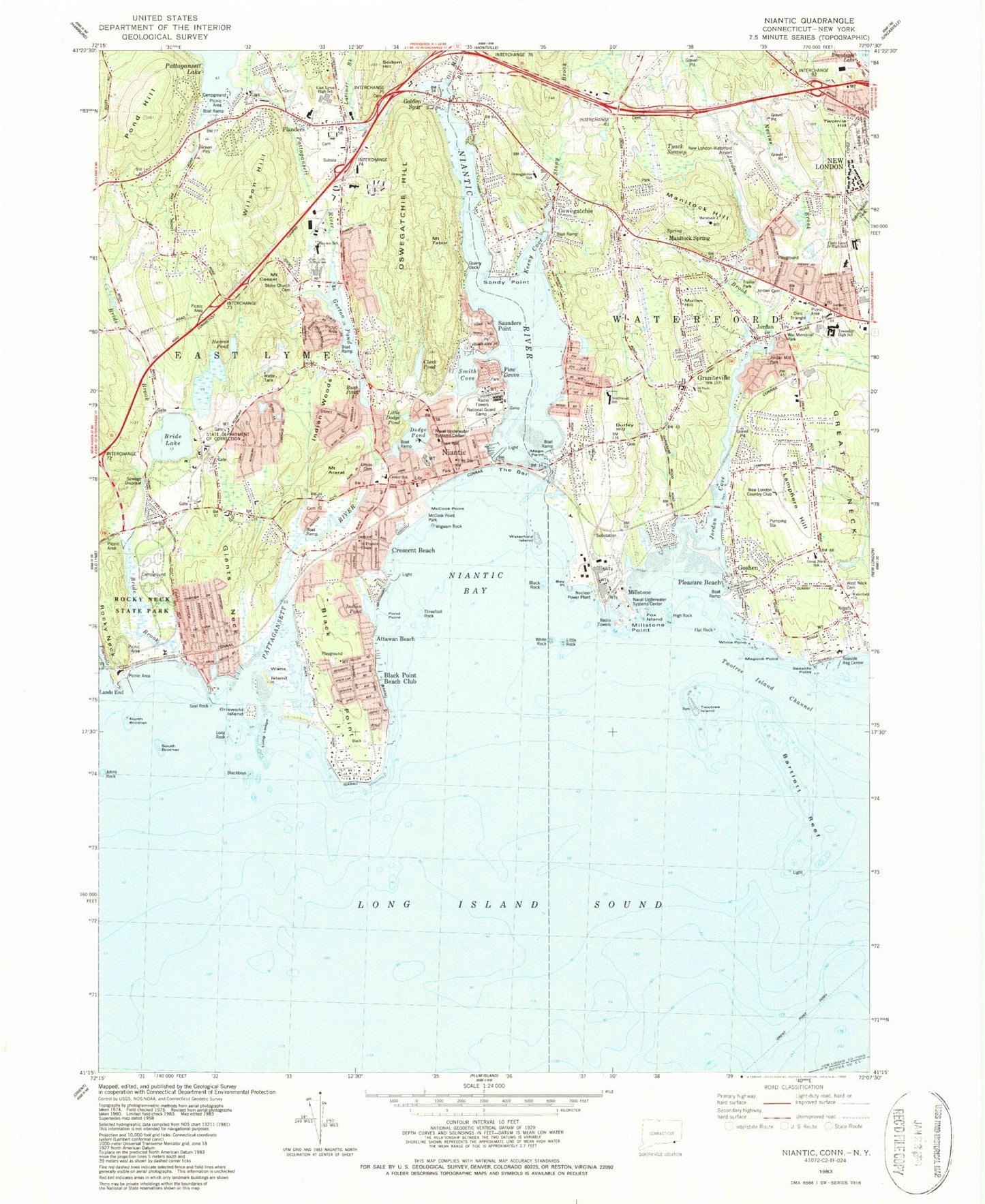
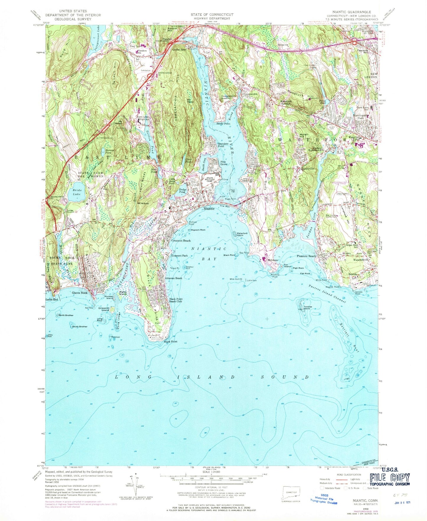
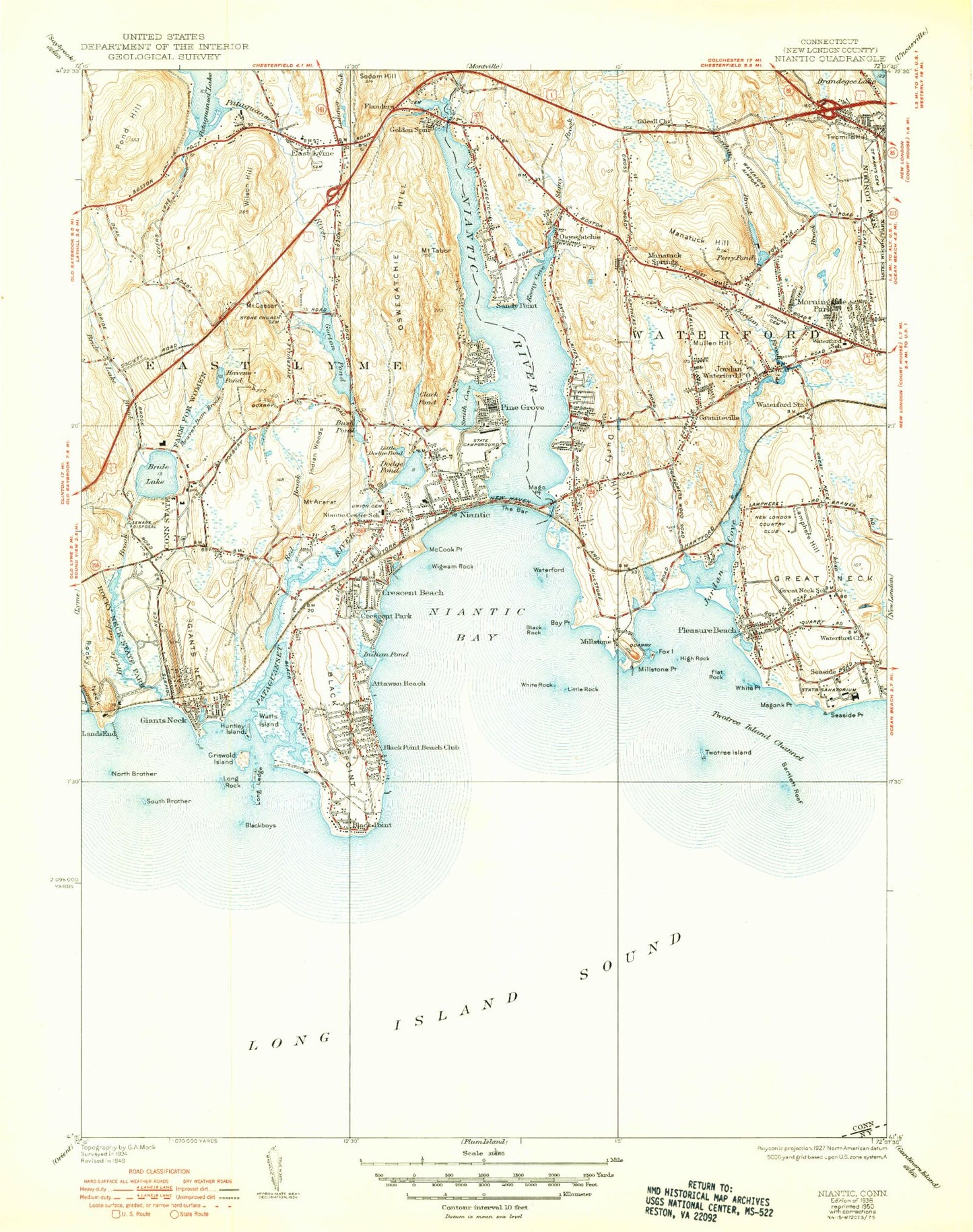
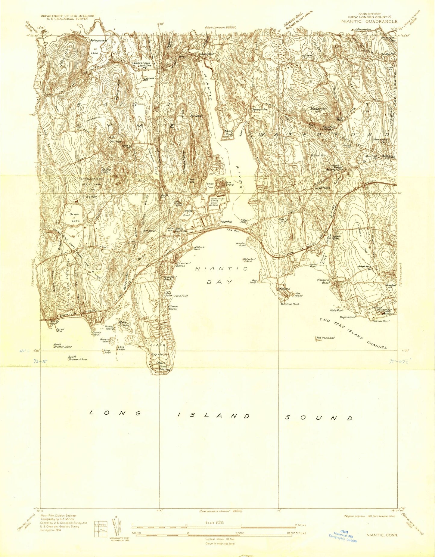
Classic USGS Niantic Connecticut 7.5'x7.5' Topo Map
Couldn't load pickup availability
Historical USGS topographic quad map of Niantic in the state of Connecticut. Typical map scale is 1:24,000, but may vary for certain years, if available. Print size: 24" x 27"
This quadrangle is in the following counties: New London, Suffolk.
The map contains contour lines, roads, rivers, towns, and lakes. Printed on high-quality waterproof paper with UV fade-resistant inks, and shipped rolled.
Contains the following named places: Mount Ararat, Attawan Beach, Bay Point, Beaver Dam Brook, Black Point, Black Point, Black Point Beach Club, Black Rock, Blackboys, Bride Brook, Bride Lake, Bush Pond, Mount Caesar, Clark Pond, Crescent Beach, Crescent Park, Dodge Pond, Durfey Hill, East Lyme High School, Flanders, Flanders School, Flat Rock, Fourmile River, Fox Island, Giants Neck, Gilead Church, Golden Spur, Gorton Pond, Graniteville, Great Neck Cemetery, Great Neck Elementary School, Griswold Island, Havens Pond, High Rock, Huntley Island, Indian Pond, Indian Woods, Johns Rock, Jordan Brook, Jordan Cemetery, Jordan Cove, Jordan, Keeny Cove, Lamphere Hill, Lands End, Latimer Brook, Little Dodge Pond, Little Rock, Long Ledge, Long Rock, Mago Point, Magonk Point, Manitock Hill, Manitock Spring, McCook Point, Millstone, Millstone Point, Morningside Park, Mullen Hill, Nevins Brook, Niantic, Niantic Bay, Niantic River, North Brother, Oil Mill Brook, Oswegatchie, Oswegatchie Academy, Oswegatchie Hill, Pattagansett Lake, Pine Grove, Pleasure Beach, Pond Hill, Pond Point, Red Brook, Rocky Neck, Rocky Neck State Park, Old Rogers Cemetery, Saint Mary Cemetery, Sandy Point, Saunders Point, Seal Rock, Seaside, Seaside Point, Smith Cove, Sodom Hill, South Brother, Stone Church Cemetery, Stony Brook, Mount Tabor, The Bar, Threefoot Rock, Twomile Hill, Twotree Island, Twotree Island Channel, Union Cemetery, Waterford Church, Waterford Island, Waterford School, White Point, White Rock, Wigwam Rock, Wilson Hill, Banning Cove, Manitock Spring, Pattagansett River, Bartlett Reef, Giants Neck, Watts Island, New London Country Club, Clark Lane Junior High School, Town of East Lyme, Town of Waterford, Gorton Pond Dam, Pataguanset Lake Dam, Jordan Mill Pond Dam, Jordan Mill Pond, Attawan Beach, Babe Ruth Field, Baptist Hill, Bride Plain, Cathedral Chapel of Christ, Center School, Charter Oak Walk-in Medical Center, Childrens Museum of Southeastern Connecticut, Christ Lutheran Church, Congregation Ohave Sholem Cemetery, Niantic Annex, Cross Roads Center Shopping Center, Crossroads Presbyterian Church, Crystal Mall Shopping Center, East Lyme Middle School, East Lyme Post Office, East Lyme Public Library, First Baptist Church, Flanders Baptist Church, Flanders Elementary School, Flanders Plaza Shopping Center, Friends Religious Society, Giants Neck Beach, Gilead Church (historical), Green Hill, The Gut, Gut Ferry (historical), Harvest Assembly of God Church, Harvest Christian Fellowship Church, Jason Elementary School, Jordan Green, Jordan Village Historic District, Kiddie Beach, Lillie B Haynes Elementary School, Little Boston Schoolhouse (historical), Little League Fields South, Marilyn Road Park, Millstone Energy Center, Millstone Information and Science Center, Millstone Nuclear Power Plant, Moran Nature Center and Zoo, Morningside Park, Niantic Baptist Church, Niantic Bay Yacht Club, Niantic Bridge, Niantic Community Church, Niantic Library Connecticut Correctional Institution, Niantic Post Office, Niantic Village Shopping Center, Nikirk Ministries World Headquarters, North Road Park, Oswegatchie Academy, Oswegatchie Elementary School, Perry Pond, Pine Grove Spiritualist Camp, Rocky Hill Neck, Rocky Neck Pavilion, Rocky Neck State Park Bathing Beach, Saint Agnes Church, Saint Ann Melkite Catholic Church, Saint Johns Episcopal Church, Saint Matthias Church, Saint Pauls Church, Sanctuary Basin, Seventh Day Baptist Church, Southwest Elementary School, Spera Soccer Field, Stenger Farm, Straightsbridge, Thomas Lee House, Waterford High School, Waterford Historical Society Colonial Village, Waterford Post Office, Waterford Public Library, Waterford Shopping Plaza Shopping Center, Waterford Station (historical), Waterford Town Hall, Wolf Pit Plain, Seaside, Niantic Census Designated Place, Waterford Census Designated Place, Jordan Fire Company Station 1, Goshen Fire Department Station 3, Flanders Fire Department, Niantic Fire Department Station 2, Oswegatchie Fire Company 4, Niantic Fire Department Headquarters, East Lyme Fire Communications, Waterford Fire Marshal's Office, Camp Niantic, Waterford, Waterford Ambulance Association, Waterford Ambulance Service - District 3, York Correctional Institution, Gates Correctional Institution (historical), East Lyme Police Department, Waterford Police Department, Mount Ararat, Attawan Beach, Bay Point, Beaver Dam Brook, Black Point, Black Point, Black Point Beach Club, Black Rock, Blackboys, Bride Brook, Bride Lake, Bush Pond, Mount Caesar, Clark Pond, Crescent Beach, Crescent Park, Dodge Pond, Durfey Hill, East Lyme High School, Flanders, Flanders School, Flat Rock, Fourmile River