MyTopo
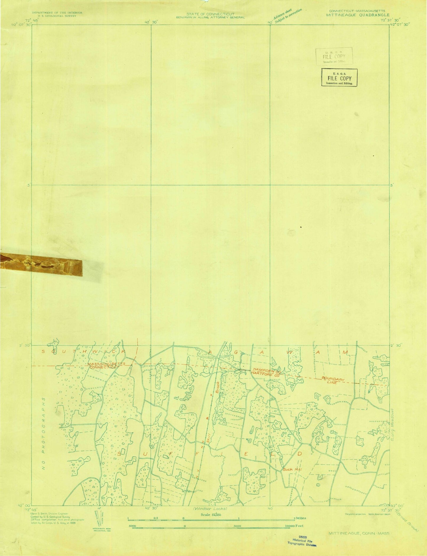
Classic USGS West Springfield Massachusetts 7.5'x7.5' Topo Map
Couldn't load pickup availability
Historical USGS topographic quad map of West Springfield in the states of Massachusetts, Connecticut. Typical map scale is 1:24,000, but may vary for certain years, if available. Print size: 24" x 27"
This quadrangle is in the following counties: Hampden, Hartford.
The map contains contour lines, roads, rivers, towns, and lakes. Printed on high-quality waterproof paper with UV fade-resistant inks, and shipped rolled.
Contains the following named places: WPKX-FM (Enfield), Hampshire and Hampden Canal, James Clark Elementary School, Obriens Corner Junior High School, Clifford Granger School, Old Tatham School, New Tatham School, Fort Meadow Elementary School, Saint Mary Elementary School, Westfield High School, East Mountain School, Paucatuck Cemetery, Springfield Aqueduct, Shaker Forms Country Club, Kingdom Hall, Pierce School, West Agawam High School, Westgate Plaza, Westgate Shopping Center, Westfield Shops, Little River Plaza, Big Y Shopping Center, Southgate Shopping Plaza, Agawam Shopping Center, Bridge Shopping Center, Mittineague Park, Robinson State Park, Veterans Field, Smith Field, Nine Lot Dam, Provost Dam, West Springfield Fish and Game Club Dam, Silver Lake Reservoir, Provin Mountain Reservoir Dam, Provin Mountain Reservoir, Strathmore Paper Company Dam, Westfield River Reservoir, Little River (historical), Paucatuck (historical), Provin Mountain, Saint Thomas the Apostle School, Mittineague Elementary School, Beth Israel Cemetery, Saint Thomas Cemetery, Mother of Sorrows Monastery, Springfield Country Club, West Springfield High School, Westfield State Sanatorium, Ashley Street School, Block Brook, Feeding Hills, Frog Hole, Great Brook, Harts Pond, Hosmer Corner, Hubbard Corner, Hundred Acre Brook, Johnson Corner, Kellog Brook, Leonard Pond, Liswell Hill, Little River, May Hollow, Miller Brook, Mittineague, North Agawam, O'Briens Corner, Paucatuck Brook, Powdermill Brook, Shea Corner, Slab Brook, Suffield Corner, Taylor Pond, West Agawam, White Brook, Pond Brook, Little River, Hampshire and Hampden Canal, Tatham, City of Agawam Town, TGP Heliport, Vergnani Heliport, Lumber Jack Field (historical), Micron Heliport, Scibelli Heliport, WACM-AM (West Springfield), WAQY-FM (Springfield), WWLP-TV (Springfield), Agawam Junior High School, Agawam High School, Agawam Middle School, Agawam Post Office, Agawam Regional Industrial Park, Agawam Town Hall, Agawam United Methodist Church, Calvary Assembly of God Church, Central Baptist Church, Church of Christ, Crestview Country Club, Cross Street Playground, Crossroads Christian Church, Emmanuel Baptist Church, Faith Bible Church, Feeding Hills Congregational Church, Feeding Hills Post Office, First Baptist Church, First Congregational Church, Grace Baptist Church, Kelly Hill, Landlord Fowler Tavern, Little River Plaza Shopping Center, Mittineague Congregational Church, Mittineague United Methodist Church, Munger Hill School, Oak Ridge Golf Club, Perry Lane Park, Resurrection Life Church, Robinson Park Elementary School, Sacred Heart Parish Center, Saint Anne Country Club, Saint Casimirs Church, Saint Davids Episcopal Church, Saint Mary High School, Shea Field, Slavic Pentecostal Church, Southwick High School, Springfield Hill, Valley Community Church, Wade Park, West Springfield Covenant Church, Westfield Post Office, Westfield Shops Shopping Center, Westgate Plaza Shopping Center, Piper Road Elementary School, Clifford M Granger School Library, Westfield Fire Department Central Headquarters Station, Agawam Fire Department Station 2, Westfield Fire Department Station 2, West Springfield Fire Department Station 2, Agawam Police Department, Buck Hill, Ebbs Corner, Glovers Hill, Great Marsh, Hastings Hill, Huckleberry Mountain, King Hill, Onion Brook, Philo Hill, Rattlesnake Swamp, Rising Corner, Scott Hill, Still Brook, Stockwell Swamp, Stony Knoll, Tinker Hill, West Suffield Mountain, Halladay Corner, Hastings Hill Historic District, Jesse F Smith Memorial Forest, Spears Pond, Zion Hill Cemetery Association, Zions Hill Cemetery, Suffield Fire Department Station #3, WPKX-FM (Enfield), Hampshire and Hampden Canal, James Clark Elementary School, Obriens Corner Junior High School, Clifford Granger School, Old Tatham School, New Tatham School, Fort Meadow Elementary School, Saint Mary Elementary School, Westfield High School, East Mountain School, Paucatuck Cemetery, Springfield Aqueduct, Shaker Forms Country Club, Kingdom Hall, Pierce School, West Agawam High School, Westgate Plaza, Westgate Shopping Center, Westfield Shops, Little River Plaza, Big Y Shopping Center, Southgate Shopping Plaza, Agawam Shopping Center, Bridge Shopping Center, Mittineague Park, Robinson State Park, Veterans Field, Smith Field, Nine Lot Dam, Provost Dam, West Springfield Fish and Game Club Dam, Silver Lake Reservoir, Provin Mountain Reservoir Dam, Provin Mountain Reservoir, Strathmore Paper Company Dam, Westfield River Reservoir, Little River (historical), Paucatuck (historical), Provin Mountain, Saint Thomas the Apostle School, Mittineague Elementary School, Beth Israel Cemetery, Saint Thomas Cemetery, Mother of Sorrows Monastery, Springfield Country Club, West Springfield High School, Westfield State Sanatorium, Ashley Street School, Block Brook, Feeding Hills, Frog Hole, Great Brook, Harts Pond, Hosmer Corner, Hubbard Corner, Hundred Acre Brook, Johnson Corner, Kellog Brook, Leonard Pond, Liswell Hill, Little River, May Hollow, Miller Brook, Mittineague, North Agawam, O'Briens Corner, Paucatuck Brook, Powdermill Brook, Shea Corner, Slab Brook, Suffield Corner