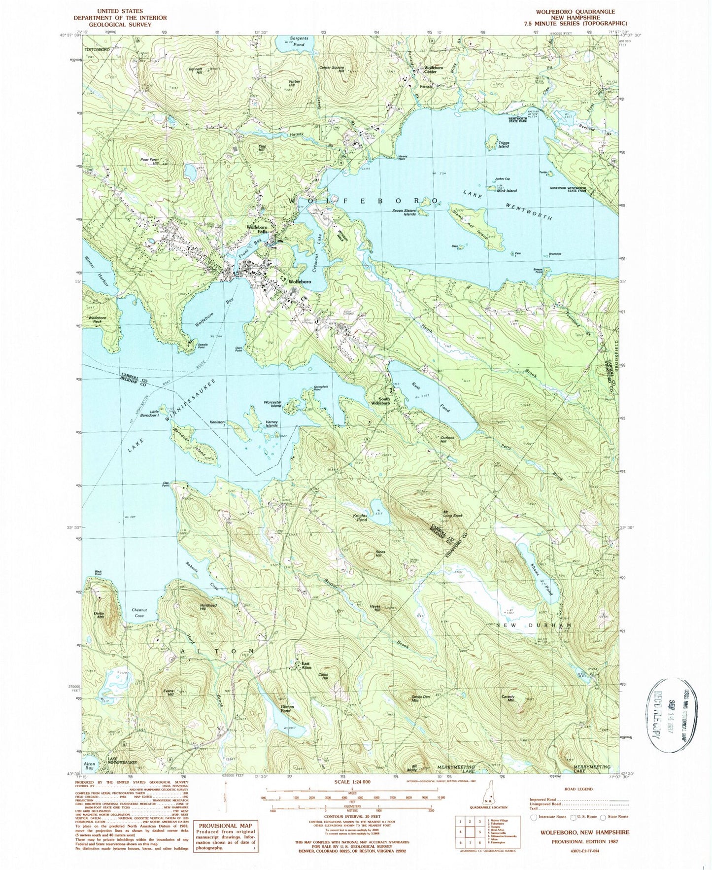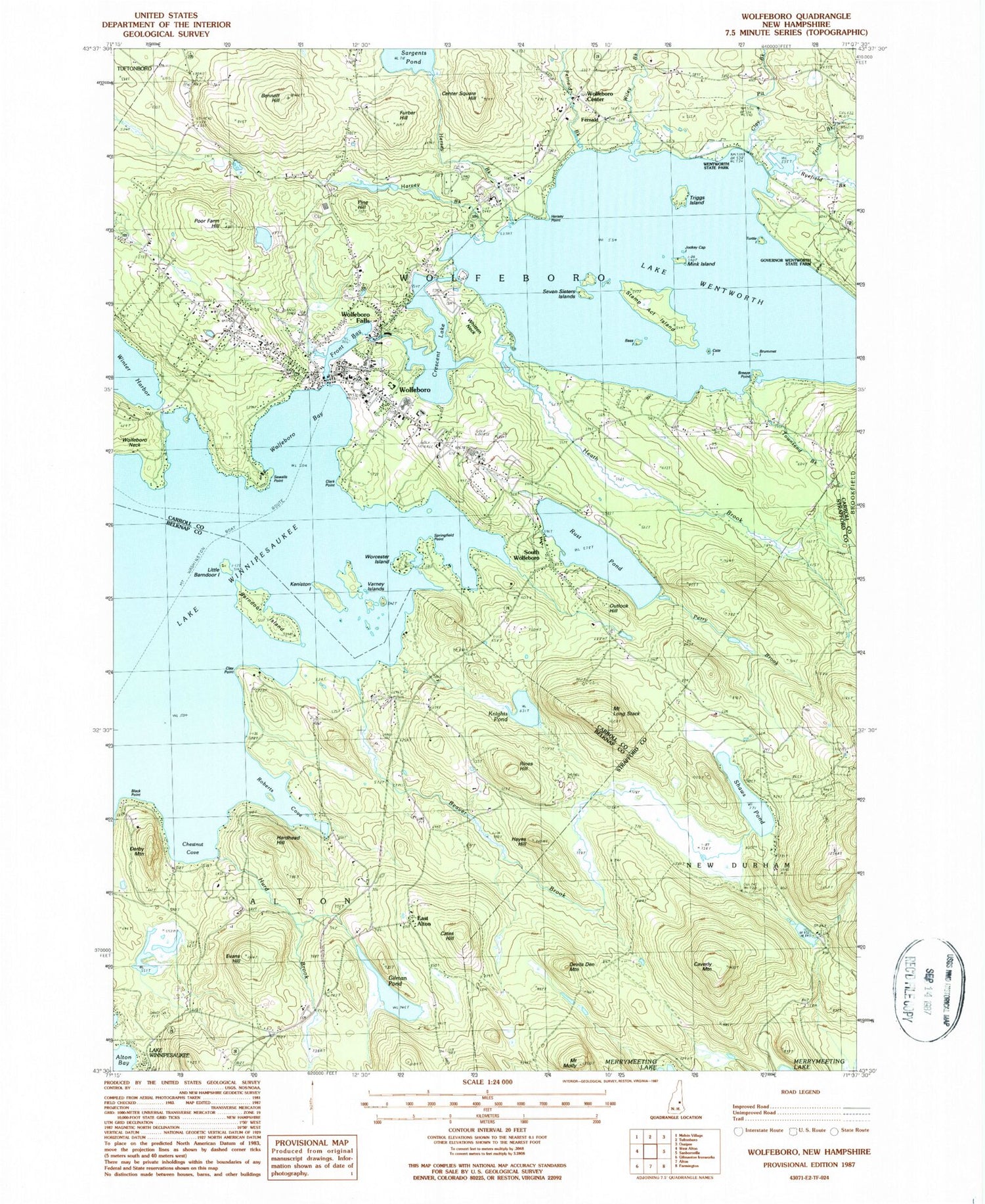
MyTopo
Classic USGS Wolfeboro New Hampshire 7.5'x7.5' Topo Map
Couldn't load pickup availability
Historical USGS topographic quad map of Wolfeboro in the state of New Hampshire. Typical map scale is 1:24,000, but may vary for certain years, if available. Print size: 24" x 27"
This quadrangle is in the following counties: Belknap, Carroll, Strafford.
The map contains contour lines, roads, rivers, towns, and lakes. Printed on high-quality waterproof paper with UV fade-resistant inks, and shipped rolled.
Contains the following named places: Barndoor Island, Bass Island, Beaver Brook, Bennett Hill, Black Point, Breeze Point, Brewster Academy, Brummet Island, Cate Island, Cates Hill, Caverly Mountain, Center Square Hill, Chestnut Cove, Clark Point, Clay Pit Brook, Clay Point, Crescent Lake, Derby Mountain, Devils Den Mountain, East Alton, Evans Hill, Fernald, Fernald Brook, Front Bay, Frost Brook, Furber Hill, Gilman Pond, Goose Rock, Gull Rock, Hardhead Hill, Harvey Brook, Hayes Hill, Heath Brook, Hersey Brook, Hersey Cemetery, Hersey Point, Huggins Hospital, Hurd Brook, Jockey Cap Island, Keniston Island, Knights Pond, Lakeview Cemetery, Little Barndoor Island, Mink Island, Mount Molly, Mount Long Stack, Outlook Hill, Perry Brook, Pine Hill, Pine Hill Cemetery, Poor Farm Hill, Rines Hill, Roberts Cove, Rust Pond, Ryefield Brook, Sargents Pond, Seven Sisters Islands, Sewalls Point, Shaws Pond, South Wolfeboro, Springfield Point, Stamp Act Island, Townsend Brook, Triggs Island, Turtle Island, Varney Islands, Wentworth State Park, Lake Wentworth, Whitten Neck, Wiley Brook, Wolfeboro, Wolfeboro Bay, Wolfeboro Center, Wolfeboro Falls, Worcester Island, Springfield Point Heliport, WASR-AM (Wolfeboro), WLKZ-FM (Wolfeboro), Town of Wolfeboro, Rust Pond Dam, Crescent Lake Dam, Spray Irrigation Storage Reservoir Dam, First Freewill Baptist Church, Pipers Point, Abenaki Ski Area, Allen Albee Beach, Baker Brook (historical), Bay Street Discount Shopping Center, Blueberry Island, Brewster Beach, Carpenter Elementary School, Cate Park, Chip Island, Church Island, Clark House Museum, Clows Beach, Delings Cove, Depot Square, Evangelical Bible Church, Fernalds Basin, First Christian Church, First Congregational Church, Fishermans Cove, Flo Island, Foss Field, Furber Point, Gate Island, Goodwins Basin, Goose Corner, Harbor Island, Harmony Island, Huggins Hospital Library, JIB Island, Jennes Landing, Jockey Cove, Joe Island, Keel Island, Kingswood Golf Course, Kingswood Regional High School, Kingswood Regional Middle School, Ledge Island, Little Kenniston Island, Long Pine Island, Loon Island, McKinney Park, Melody Island, Min Island, Moose Point, Morrill Brook, Mud Island, Overnight Island, Perry Hollow Golf and Country Club, Point of Pines, Poplar Island, Puffs Cove, Ryefield Marsh, Scavenger Island, Shelter Island, South Wolfeboro Bay, South Wolfeboro Playground, Spider Island, Sunset Point, Tips Cove, Trapper Pond, Triggs Landing, Union Church, Upper Shore Island, Wal Island, West Jockey Cap Island, Winch Island, Wolfeboro Centre Community Church, Wolfeboro Chamber of Commerce, Wolfeboro Falls Post Office (historical), Wolfeboro Fire Rescue Department, Wolfeboro Full Gospel Fellowship, Wolfeboro Post Office, Wolfeboro Public Library, Wolfeboro Town Beach, Wolfeboro Shopping Center, Wolfeboro Town Docks, Wolfeboro Town Hall, Wright Museum, Frost Corner, Wolfeboro Census Designated Place, Crescent Lake School, East Alton Fire and Rescue Department, Lord Ambulance Service / Lakeside Ambulance Service, Wolfeboro Police Department, Wolfeboro Falls Post Office